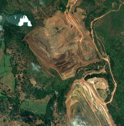
The extent of illegal mining in the state could be tracked from the 
Google Earth software, by comparing the google images with the Regional plan, 2021, a senior environmentalist and Padmashri and Padma Bhushan awardee Prof Madhav Gadgil said today.
Prof Madhav Gadgil, heading Ministry of Environment and Forest’s panel on Western Ghat, said that the virtual pictures of all the mines are very clearly seen on Google earth.
“Everybody can see it and find out how much is illegal,” he told a convention at Dona Paula, near here today.
“Regional Plan 2021, a document prepared by State government, shows legal borders of the mines. If we compare the RP with Google images, we can come to know about the illegal mining,” he added.
Gadgil was participating in the convention of Goan youth on ‘Environment and Developj ment’, organised by Centre for Environment Education, an NGO and the Goa Golden Jubilee Development Council.
The environmentalist commented that each citizen of the state has a right to ask government about the illegal mining.
By DigitalGoa