Google Earth: Baseline to baseline, we’ve got the basketball games covered

Do you hear the dribble on the court and the chanting of the fans? Following an action-packed week of buzzer beaters, the 2011 NCAA® Championship here in the U.S. promises to be as exciting as ever.

As a college hoops fan, I often wish I could experience the games sitting in the arenas—and I’m sure I’m not alone. This year, our college basketball tournament map lets you get as close as you can to the games without leaving your desk thanks to 3D models of the tournament’s 14 arenas. Take a virtual tour of the venues by watching the video below, or download this tour and open it in Google Earth.

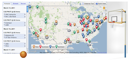
Plus, we’ve created a special page for you to keep track of all the excitement during the next few weeks. You can see an up-to-date tournament schedule, explore the college campuses in Street View and click through to watch the actual games on NCAA® March Madness on Demand®. You can also create a bracket using Google Docs, read Google News articles on the games and download basketball apps from the Chrome Web Store. It’s all here (along with a fun surprise) at www.google.com/collegebasketball2011.

And since there’s been a long-running debate over whether teams playing closer to their home court have an advantage, we added a “Distance Tool” on the map to make it easier to measure how far schools have to travel from game to game. We’ll see how things play out, but the defending champion Duke Blue Devils may have to travel more than 2,000 miles to Anaheim if they win their first two games.

As my friends always say when we can’t wait for the tournament to begin, “Send it in, Jerome!” May your favorite school reach the finals and we hope you enjoy all the basketball fun at www.google.com/collegebasketball2011.

Posted by Aaron Weissman, Google Maps Marketing (San Francisco King of the Rock winner)

Youtube Video from Earthquake in Tokyo Japan

An 8.9-magnitude earthquake followed by a 10-foot tsunami hit the coast of Japan at 2:46 p.m. Tokyo time Friday. It was the most powerful recorded in the country’s history, and the seventh largest ever recorded worldwide.

Victims and concerned parties quickly turned to the web to share news and footage. With the country’s phone system down, tweets topped more than 1,200 per minute from Tokyo within the first hour of the quake. Both Ustream and Al Jazeera, among others, posted live video feeds online.

Citizens have also taken to Flickr and YouTube to share eyewitness accounts from inside their homes and public buildings, and from the streets with their neighbors. We’ve compiled five of the most illustrative here, most of which are from Tokyo, situated 230 miles from the earthquake’s epicenter. (According to early reports, the earthquake originated off the coast of Honshu, the most populous of Japan’s islands.)

Come across any additional, noteworthy footage? Please share it in the comments section below. You can also check out YouTube’s CitizenTube channel, which is continually updating a playlist with more content.

An apartment in Tokyo

Gym in Tokyo

Grocery Store

____________________________________________________________________________________________

___________________________________________________________________________________________

A Google Street View showcase…

Since Street View first launched in Google Maps, it’s grown from five U.S. cities to locations on all seven continents, and we’ve been able to visit some beautiful and historic places around the world. To share some of our favorite imagery with you, and also give you a behind-the-scenes look at Street View technology, we’ve updated our Street View site.

Site homepage, featuring Kirstenbosch National Botanical Garden, Cape Town, South Africa

In addition to the places on the site homepage, we’ve included highlights from around the world in a gallery that lets you see ski slopes, UNESCO World Heritage sites, and breathtaking places on all seven continents.

Street View gallery, featuring Old Town of Segovia and Its Aqueduct

While we’ve been able to photograph most places in Street View with our cars, plenty of unique and interesting locations around the world aren’t accessible by car. To help us visit places with smaller paths or unpaved terrain, we’ve developed the Trike, Snowmobile and Trolley, which have enabled us to share parks, ski trails, and even museums with you in Street View. You can now check out pictures and 3D models, and learn more about all of these platforms on the site.

Once we collect new imagery, we “stitch” the individual photographs into the 360-degree imagery you see in Google Maps. The revamped site provides an in-depth look at this process and shows the progression of photos into the immersive Street View experience.

You can also learn about how to use Street View, meet our friendly mascot Pegman, read about our cutting-edge face and license plate blurring technology, or see where Street View is available across the world.

We’re starting with this update for our United States site, and will continue rolling it out for more countries in the coming months. Start exploring new places at maps.google.com/streetview.