Engineering a network in Haiti with Google Earth

In the time since the tragic earthquake in Haiti 14 months ago, we’ve seen a variety of uses of Google Earth to help cope with the event in various ways.

Today we’re looking at how the Church of the Resurrection in Kansas City is using Google Earth to prepare for an upcoming relief trip to the country.

Last year, the church sent 15 teams to Haiti to help repair and rebuild various facilities including churches, schools, medical clinics, and more. However, the teams had a very difficult time communicating with their support systems in the US due to poorly-operating internet connections and wifi.

Last April, Clif Guy went down to help troubleshoot and repair/upgrade internet service in the Methodist guest house in Port-au-Prince so that subsequent teams would be able to stay in communication. During that trip and over the next 6 months he made major improvements and through the process learned a great deal about ISPs in Haiti and the challenges of dealing with intermittent service and intermittent availability of electricity.

This weekend he’s heading back down to Haiti to install network infrastructure and Internet connections in five Methodist buildings in the small town of Petit Goave, on the coast 42 miles west of Port-au-Prince. One of the five buildings is a school (College Harry Brakeman) where they will also be setting up a computer lab for use by high school students. Since Internet connections are very expensive in Haiti, it’s much more economical to install a primary and backup connection and then distribute the connections to the five buildings via radio links rather than purchase a separate connection for each building.

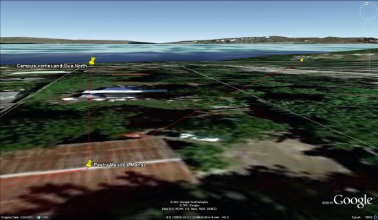
Working with a volunteer (retired manager from AT&T) who is their advance person in Petit Goave, they used Google Earth to mark the locations of the facilities that need Internet access. Once they had locations identified, they were able use Earth to perform a virtual site survey – distance between buildings, building elevations, terrain profiles along the paths between buildings, etc. in order to engineer a building-to-building wireless network. He chose a central location on the highest ground and with the best electrical power to be our network hub. Using Earth and some simple trigonometry he was able to select directional antennas that will allow them to establish the links from the hub to the other buildings with the minimum number of radios.

petit-goave.jpg

It’s an impressive piece of work. The files aren’t as complex as many that we’ve shown you over the years, but the simple fact that they were able to do so much planning from so far away because of Google Earth shows just how useful it can be.

If you’d like to view their plans in Google Earth, you can download the KMZ file here. Buildings are marked with yellow push pins. Radio links are marked with red paths.

Unlock offers, check in, and gain status with Google Latitude in Austin

Do you have a go-to restaurant you love – a place where everybody knows your name? If you’ve been checking in there from Google Latitude in Google Maps for Android, we want to help you get a little extra love right back. After launching check-ins for Latitude last month, today we’re rolling out our first check-in offers at more than 60 great places in Austin, Texas.

Checking in from Google Latitude lets you easily share the places you go with friends, and you can even choose to get check-in notifications or automatically check in to make it even easier. In addition to sharing places, you can also gain status as a “Regular”, “VIP”, or “Guru” at places depending on how often you’ve checked in there. You can even see your progress along the way by tapping your current status. I’ve been checking in almost everywhere I go, and after a steady stream of caffeination at my favorite coffee shop, I’m proud to be a Guru there!

From the Place page, find available check-in offers (left); tap your status to see where you stand and find your check-in history (right).

In addition to pride, you can now unlock check-in offers that places have created for your status level. So, a restaurant or shop can give their Regulars a reason to keep coming back and their Gurus an awesome reward for their loyalty. Check-in offers can be as creative as places want for any of the three status levels. You can find places where check-in offers are available in Google Maps for Android search results and Place pages.
See if a place has check-in offers available in your Google Maps for Android search results.
You’ll be able to see both available and locked check-in offers. And once you gain status and unlock a check-in offer, just tap Redeem and show your phone to use it. Learn more at google.com/mobile/checkin.

See locked offers and ones available at your status level (left); tap an unlocked one and redeem it (right).
We’re kicking off check-in offers in Austin this week, and we’re working on bringing them to more people and more places. If you’re in town for South by Southwest this week or just happen to live near Austin, find check-in offers at some of its finest establishments, such as:
  • Free coffee for Regulars at Frank
  • Free sundae from the cafe for VIPs at Toy Joy
  • Buy a slice and get one free during certain hours for VIPs at East Side Pies
  • 10% off any upcoming event book for Gurus at BookPeople
  • 20% off select merchandise for Gurus at Waterloo Records
Find all the check-in offer locations in Austin on a map, and then see more details by opening their Place pages in Google Maps for Android.
To get started unlocking offers, update to Google Maps 5.2 in Android Market (requires Android 1.6+) and tap Check in here from a Place page or from Latitude’s menu. If you haven’t yet, join Latitude and check in wherever you go. And if you’ve got an iPhone, the Latitude app for iPhone will be updated with check-ins and check-in offers soon.

Japan: Visit the Hiroshima Peace Memorial in Street View

We’ve added many historic sites to Street View to let you explore these places online, and now we’ve included Street View imagery of the Hiroshima Peace Memorial,  also known as the “Atomic Bomb Dome.” On August 6, 1945 at 8:15am, the first nuclear device to be used in warfare exploded almost directly above this building. The annihilated structure became an iconic symbol of the bomb’s devastation, and despite rebuilding the rest of the city, Hiroshima decided to keep the Dome in its post-war condition to stand as a living testament to the horror of nuclear conflict.

The Atomic Dome has always been an important reminder of history, but also a living beacon for the message of global peace. The desire to experience the Peace Memorial as a physical space makes it a great match for Street View, which both enables people around the world to tour the site virtually and also preserves this important imagery for the next generation. We hope that the imagery will inspire users outside of Japan take a new interest in Hiroshima’s history and think deeply about the importance and meaning of peace.

Along with this Atomic Dome imagery, we have also added special collections of seven places in Hiroshima Prefecture, including Hiroshima Peace Memorial Park and the “floating” Itsukushima Shrine at both high and low tide.