GpsGate Server can do more than real time GPS tracking


GpsGate Server can do more than real time GPS tracking.

<Clustering sample>

In addition to real time GPS tracking GpsGate Server has advanced functionality to help solve business issues, improve productivity and enhance the user experience.

Cool GpsGate Server functionality:

  • Vehicle and Alarm Clustering: Group multiple objects to improve visibility on busy maps
  • Roles, Views and Workspaces: Manage your users access and adapt the user interface to their tasks
  • Event Rule Wizard: Set up new business rules and alerts in minutes
  • Dynamic Tags: Configure views that automatically show the “right” vehicles on the map
  • GpsGate Mobile: Manage your fleet from your iPhone and Android devices
  • Device Manager: Batch management of multiple tracking devices
  • One-click updates: Update your server and add new features directly in the web interface

GpsGate helps you simplify and improve your business!
Read more about cool GpsGate Server functionality


<Report image>

GpsGate Reporting

We have published a guide that shows you how to setup and configure your own reports in GpsGate Server. You can use this guide to understand how to change the standard GpsGate Reports and how to add new ones.

GpsGate Reporting Guide

Get GpsGate Server!

GpsGate Server has a freelicense for five users both for private and commercial use.

Download GpsGate Server


Track your laptop with GpsGate Client

You can track your laptop on GpsGate Server using the free GpsGate Client.

Read more / Download


GpsGate video tutorials

GpsGate videos
Have a look at our collection of video tutorials to get familiar with GpsGate Server.

GpsGate videos


Is your GPS tracking device supported?

GpsGate Server supports well over 100 different tracking devices. New devices are added all the time!

Supported device list


Travel as a Roman

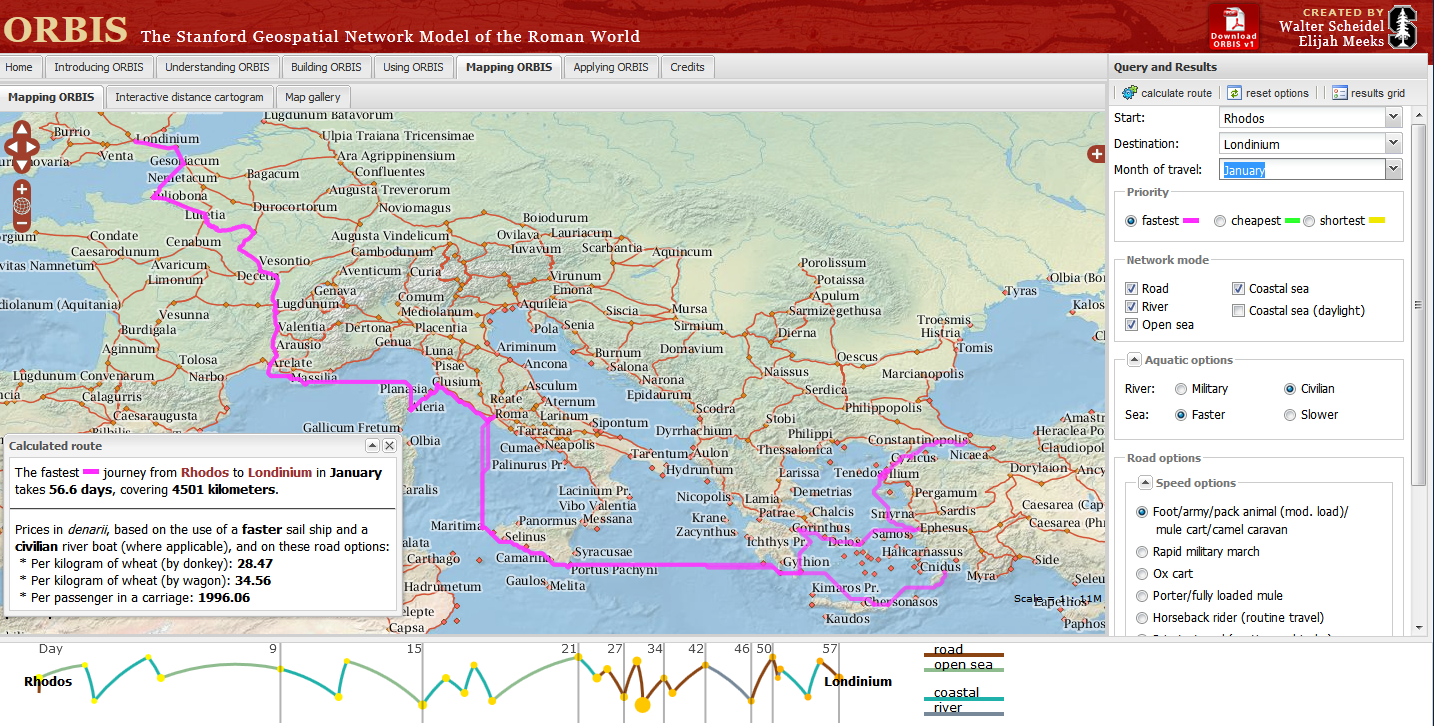
Stanford University have created a “Geospatial network model of the Roman world”
Impressive Interactive Map that can calculate  travel times and cost (in Denarius)
ORBIS, can calculate journey times between 751 locations in the Roman world. The site draws data from The BarringtonAtlas of the Greek and Roman World which has  been georeferenced by Cambridge University Students. To calculate voyages on water, the site uses maps of rivers. Sea journeys are also possible, with routes calculated from the Romans’ preferred sea routes. Dijkstra’s pathfinding algorithmis applied to calculate routes.
The Mapping tool also calculates route dependent on the month for a journey, as weather conditions at sea and on land had a major impact on ancient travel times.
Users can choose from a menu of transport/travel options:
  • Foot/army/pack animal, mule cart/camel caravan
  • Military March (Rapid)
  • Ox & cart
  • Fully loaded mule
  • Horseback rider (routine travel)
  • Private travel (routine, vehicular)
  • Private travel (accelerated, vehicular/horseback)
  • Fast carriage
Try the Roman Travel Interactive Map:
Information on the Geospatial Technology used is see the section tabs:
Building ORBIS: Multi-modal network model via the Building ORBIS tab and selecting the Geospatial Technology Tab.
via:mapperz.blogspot.com

The smartphone growth is global

Last October, we launched Our Mobile Planet, a resource enabling anyone to visualize the ways smartphones are transforming how people connect with information, each other and the places around them.

Today, we’re releasing new 2012 research data, and the findings are clear—smartphone adoption has gone global. Today, Australia, U.K., Sweden, Norway, Saudi Arabia and UAE each have more than 50 percent of their population on smartphones. An additional seven countries—U.S., New Zealand, Denmark, Ireland, Netherlands, Spain and Switzerland—now have greater than 40 percent smartphone penetration. In the U.S., 80 percent of smartphone owners say they don’t leave home without their device—and one in three would even give up their TV before their mobile devices!

We conducted this research to help people to better understand how mobile is changing our world. You can learn about mobile-specific usage trends, use this tool to create custom visualizations of data and more. There’s plenty to discover in the latest research—to dig into new survey data about smartphone consumers in 26 countries from around the world, read our post on the Google Mobile Ads blog or visit http://thinkwithgoogle.com/mobileplanet.