Street View’s Hot or Not
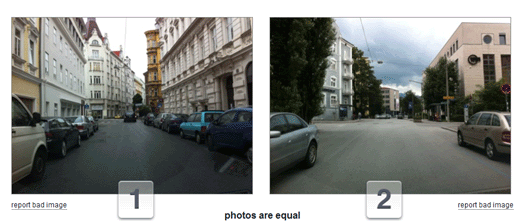
MIT’s Place Pulse project is a crowd-sourced experiment examining people’s perceptions of different urban environments.
The project presents two Street View images from Google Maps and asks users to vote for which place looks more ‘unique’, ‘safer’ or ‘upper class’.
As well as contributing to the research by answering the questions you can view the results and view which of the Street Views appear most or least safe, unique or upper-class.
Standard & Poor’s Credit Ratings Map
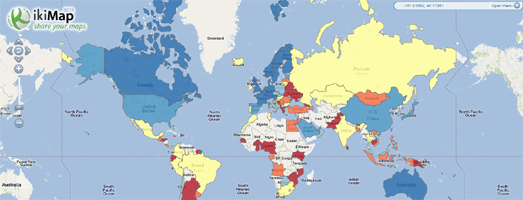
Standard and Poor’s downgrading of the USA’s credit rating to AA has sent shock-waves around the world.
You can consult this Standard and Poor’s Credit Rating Map to see the current credit ratings of countries around the world. The map was created with the Ikimaps Google Maps creation tool.
Standard & Poor’s (S&P) is a United States-based financial services company. It is a division of The McGraw-Hill Companies that publishes financial research and analysis on stocks and bonds.
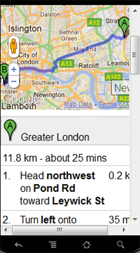
Mobile Place Maps
Mobile Place Maps is a mobile friendly directions map creation tool.
The tool can be used to quickly get directions on your mobile phone. It can also be used by businesses and other venues to provide a link to a mobile friendly map showing the directions to their business from the nearest subway or train station.
The tool automatically detects your current location, so all you have to do is enter your destination. After you have entered a destination the tool will create driving, cycling or walking directions for your journey. The route of your journey is displayed on a Google Map and step-by-step directions are displayed beneath the map.
Once you have created a directions map with the tool you are also given a weblink. It is therefore possible to share your directions map with friends or create a link on a website to your directions map.
Hipmunk – Your Hotel & Hotspot Finder
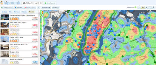
Hipmunk, the flight planning and booking tool, has added a new hotel search function that includes an interesting hotspot facility.
Hipmunk allows users to search for hotels by location and date. The results of each search are shown on a Google Map, with green markers showing the cheapest rates and red the most expensive. It is also possible to sort the results by price, reviews and distance.
Hipmunk also allows users to overlay a number of heatmaps over the results. The heatmaps help the user to see which areas of their destination have high and low concentrations of restaurants, museums, bars etc.
The heatmaps are a useful tool, especially for users booking hotels in unfamiliar locations. In many ways the function improves on Google Hotel Finder’s tourist spotlight feature.
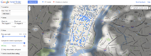
When you search for a hotel with Google Hotel Finder the map tourist spotlight highlights the most popular areas for visitors to stay.
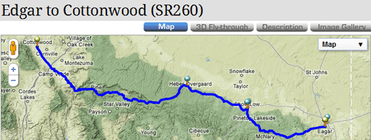
Motorcycle Roads is a community driven guide to great motorcycle rides in America. Each of the great motorbike rides is accompanied by a Google Map of the ride’s route.
Each mapped route includes details about the ride’s length, road quality and roadside amenities. The scenery, road quality and amenities are each rated by the route’s submitter and include written details.
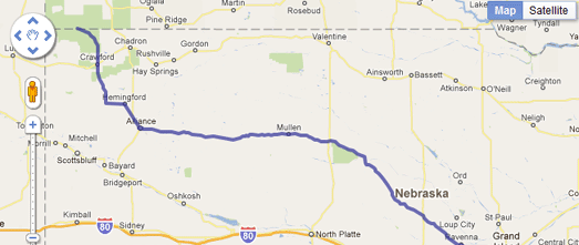
Sunday Morning Rides has used Google Maps to map over 1,500 great motorbike rides throughout the USA.
You can search for rides by state and view each ride on its own map. Each route comes with an interactive elevation chart, which, if you mouseover, shows the Street View for that location.
Motorcycle Network is a directory of everything to do with motorcycles in Australia. The site uses Google Maps to show all the parking spots in the major cities and also show all the motorcycle and scooter dealers, mechanics and gear shops, as well as all the training facilities, tours, insurance and hire places around Australia.
Denis Hopper’s Easy Rider is to many the seminal counter-culture movie of the 1960’s. Some of us may never get the chance to ride a bike across the States but thanks to Mr Zip we can follow the route on Google Maps.
Mr Zip has pieced together the locations used in the film and managed to put together a rough approximation of the route. The map itself is simple enough, showing the route in blue, with a few map markers showing the locations of the main scenes in the movie.
Via: GoogleMapsMania

