TripGeo – Directions with Video Streetview

TripGeo – Directions with Video Streetview

If you need a directions widget for your business, school or college you could do a lot worse than embed a free Directions Map widget on your website. TripGeo Directions uses Google Maps to help users create an embedable driving directions map for their website or blog.

TripGeo - Directions with Video Streetview  NYC


The really fun part of this Google Maps based widget however is that it also allows you to create animated Street View tours. If you just add a starting point and a destination to Directions Map you can then view the route entirely in Street View.

Directions Map allows users to create driving directions from any starting point to any location. Users can also define the height, width and the map type of their widget. Once the widget has been embedded on a website it can then be used to follow the given driving directions or to view an animated walk-through of the route in Street View.

The animated walk-throughs of routes with Street View are very impressive. Given the impressive nature of these Street View animated routes I can see Directions Map also being used by websites to create virtual tours. In fact Directions Map has created a number of example animated Street View routes for locations around the world.”

TripGeo - Directions with Video Streetview
Glide along with directions and video streeview (click play).

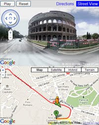
Here are links to some of the example animated Street View routes:

Chapmans Peak Drive, South Africa
Chateau d’Eox , Switzerland
Golden Gate Bridge
Colosseum, Rome
Las Vegas Boulevard
London, from the Houses of Parliament to the British Museum

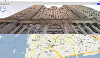
Because Directions Map uses dynamic URL’s you can even play about with the web address to quickly create your own routes by changing the start point and destination in the URL.

Here is the URL for New York to Boston:

http://s3.tripgeo.com/dirmap/map.htm?from=New%20York&to=Boston

If you want to view a Street View animation of the route from New York to San Francisco just change ‘Boston’ to ‘San Francisco in the URL above. So what routes can you create. Post links to your routes in the comments below.

Update: microformats.dk has quickly created a page combining a Directions Map Street View tour of the Alpe d’ Huez with a Kraftwerk YouTube video. Superb!

Travellerspoint.com

Travellerspoint.com

helps you plot future and past trips on a map. Control trip colours, curves, transport modes.

“The goal of Travellerspoint is to create an international meeting point for travellers worldwide, whether they are planning their travels, currently travelling or have returned from their travels and want to stay in touch with (or find) those travel friends they met while travelling in the past.”

TravellersPoint.com Map

http://www.travellerspoint.com/guide/

Getting started with Google Earth

I’ve had a few people email me recently and ask essentially the same question:

“I’m new to Google Earth. What can I do to learn more about it?”

If you’re a new user, or a veteran user wanting to learn more, this post should give you some direction. In no particular order, here are some places to learn more about Google Earth:

Google.com/Earth — The official home of Google Earth on the web has a ton of great info. In particular, check out their Beginner Tutorials to learn some of the basics.

Our “Google Earth Basics” page — Frank assembled this page when Google Earth first came out, and the various sections are updated periodically to keep things current. It’s a great resource for learning the basics such as how to navigate, using the overview map, working with historical imagery and much more.

• Our Recent Archives Simply view the archives on the side of the page to see our recent posts to catch up with the latest Google Earth news. You can even focus on our “Google Earth News” category to only see the latest updates from Google (new imagery, new features, etc).

• A community such as the Google Earth Community or Google Earth Hacks — Finding places where you can talk to other Google Earth Users is a great way to ask questions, share information, and learn more about the great things you can do with Google Earth.

My Twitter “Geo” list — I’ve created a list on Twitter (a group of people to follow) that is focused specifically on Geo-related users and includes 55 people so far. You’ll find people like:

— Google Employees Bruce Polderman, Mike Pegg and Mano Marks.

— Info from other sites like Ogle Earth and Google Maps Mania.

— 3D modelers like Kevin DeVito or the official 3D Warehouse account.

— Imagery providers such as TeleAtlas and GeoEye.

Beyond that, just dig in! Play with the built-in layers, search for fun places to visit, and just get familiar with moving around the globe.

If you have any other great “getting started” sources to add, please leave a comment on this post and let us know!