Travel as a Roman

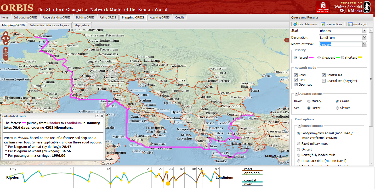
Stanford University have created a “Geospatial network model of the Roman world”
Impressive Interactive Map that can calculate  travel times and cost (in Denarius)
ORBIS, can calculate journey times between 751 locations in the Roman world. The site draws data from The BarringtonAtlas of the Greek and Roman World which has  been georeferenced by Cambridge University Students. To calculate voyages on water, the site uses maps of rivers. Sea journeys are also possible, with routes calculated from the Romans’ preferred sea routes. Dijkstra’s pathfinding algorithmis applied to calculate routes.
The Mapping tool also calculates route dependent on the month for a journey, as weather conditions at sea and on land had a major impact on ancient travel times.
Users can choose from a menu of transport/travel options:
  • Foot/army/pack animal, mule cart/camel caravan
  • Military March (Rapid)
  • Ox & cart
  • Fully loaded mule
  • Horseback rider (routine travel)
  • Private travel (routine, vehicular)
  • Private travel (accelerated, vehicular/horseback)
  • Fast carriage
Try the Roman Travel Interactive Map:
Information on the Geospatial Technology used is see the section tabs:
Building ORBIS: Multi-modal network model via the Building ORBIS tab and selecting the Geospatial Technology Tab.
via:mapperz.blogspot.com

Ingres Db

The latest version of Ingres relational database now also includes support for geospatial data. GIS functions and spatial data types are included out-of-the-box (i.e. do not require additional plug-ins) and make it easy to enable web mapping. Ingres 10S supports spatial applications, such as Esri’s ArcGIS for Desktop and FME but also MapServer and GeoServer.

Ingres 10S is supported by other programming libraries including GDAL/OGR and GeoTools, allowing import, export and manipulation of vector data. Ingres 10S leverages the GEOS geometry and PROJ cartographic projection libraries for manipulating and transforming spatial data between dozens of geographic and planar co-ordinate systems.

Ingres 10S is an open source, enterprise grade database, not as popular as MySQL or PostgesSQL but, as the other options, can be downloaded and used for free. Ingres was first created as a research project at the University of California, Berkeley in the early 1970s. Since the mid-1980s, Ingres has spawned a number of commercial database applications, including Sybase, Microsoft SQL Server, NonStop SQL, but also open source PostgreSQL (which with PostGIS extension is the most popular open source spatial database).