Jean Baptiste Bourguignon- A general map of the World or terraqueous globe with..
Author: Anville, Jean Baptiste Bourguignon d, 1697-1782; Dunn, Samuel; Riccioli, Giovanni Battista; Robert Laurie &
James Whittle
Date: 1799
Short Title: Composite: World.
Publisher: Laurie & Whittle London
Type: Composite Map
Obj Height cm: 105
Obj Width cm: 124
Scale 1: 43,000,000
Note:
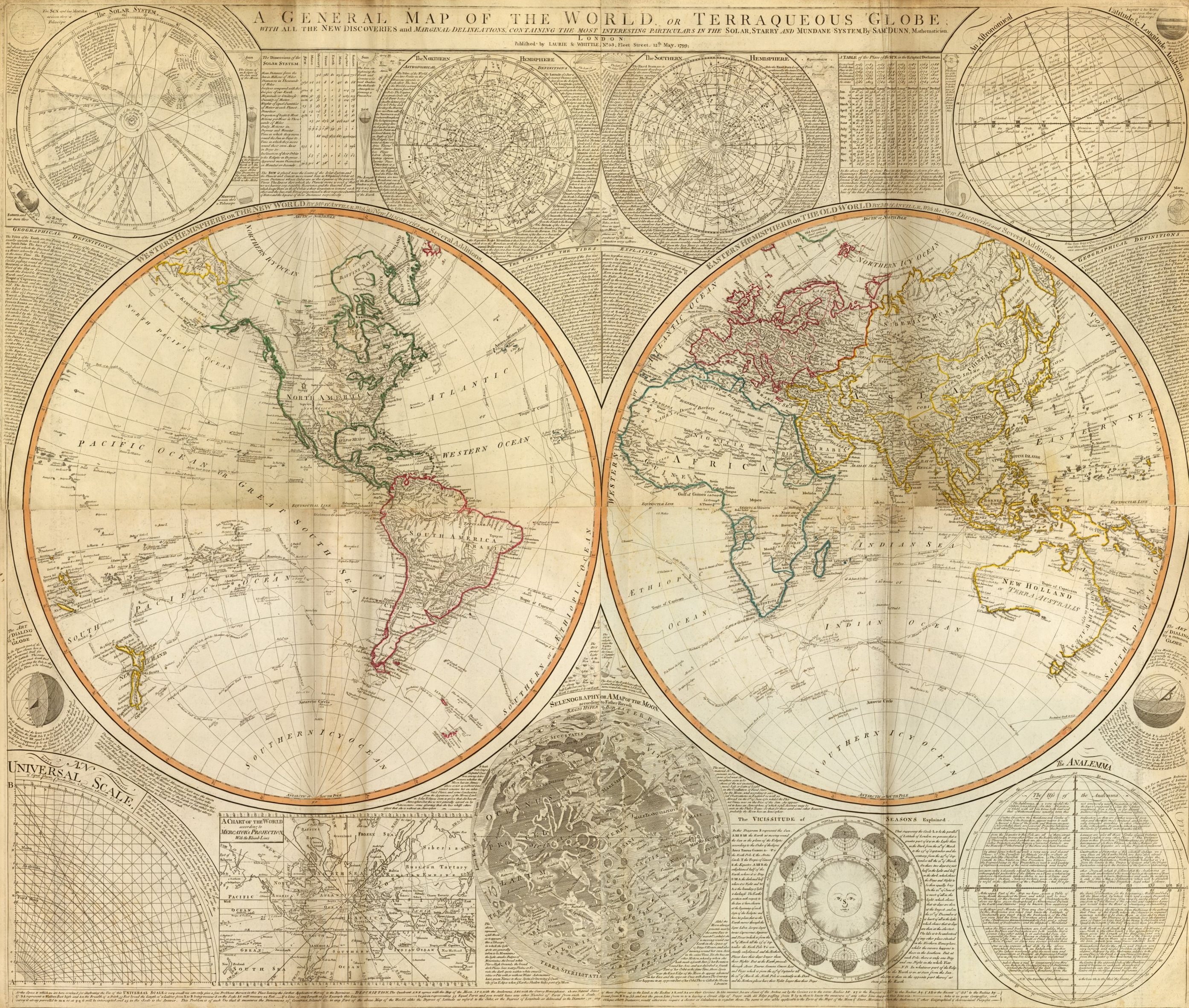
Digital composite of north and south halves of hand colored engraved map. Relief shown pictorially. Contents: Western Hemisphere or the New World by Mr. d’Anville, with new discoveries and several additions — Eastern Hemisphere or the Old World by Mr. d’Anville, with the new discoveries and several additions. Ancillary maps or charts: The Solar System — The Northern Hemisphere — The Southern Hemisphere — An astronomical latitude & longitude analemma — An universal scale — A chart of the World according to Mercator’s projection, with the rhumb lines — Selenography or A map of the Moon according to Father Riccioli — The vicissitude of seasons explained — The analemma. Printed on 4 sheets; joined as 2.
World Area: World
Subject: Celestial
Full Title:
(Composite of) A general map of the World or terraqueous globe with all the new discoveries and marginal delineations, containing the most interesting particulars of the solar, starry and mundane system, by Saml. Dunn, mathematician. London, Published by Laurie & Whittle, No. 53, Fleet Street, 12th May, 1799.
Author: Anville, Jean Baptiste Bourguignon d, 1697-1782; Dunn, Samuel; Riccioli, Giovanni Battista; Robert Laurie &James WhittleDate: 1799Short Title: Composite: World.Publisher: Laurie & Whittle LondonType: Composite MapObj Height cm: 105Obj Width cm: 124Scale 1: 43,000,000
Note:Digital composite of north and south halves of hand colored engraved map. Relief shown pictorially. Contents: Western Hemisphere or the New World by Mr. d’Anville, with new discoveries and several additions — Eastern Hemisphere or the Old World by Mr. d’Anville, with the new discoveries and several additions. Ancillary maps or charts: The Solar System — The Northern Hemisphere — The Southern Hemisphere — An astronomical latitude & longitude analemma — An universal scale — A chart of the World according to Mercator’s projection, with the rhumb lines — Selenography or A map of the Moon according to Father Riccioli — The vicissitude of seasons explained — The analemma. Printed on 4 sheets; joined as 2.
World Area: WorldSubject: Celestial
Full Title: (Composite of) A general map of the World or terraqueous globe with all the new discoveries and marginal delineations, containing the most interesting particulars of the solar, starry and mundane system, by Saml. Dunn, mathematician. London, Published by Laurie & Whittle, No. 53, Fleet Street, 12th May, 1799.
The Art Of Maps:

![]() is roughly 108MB! They’re already working on ways to reduce the size of that, likely putting it into a network link so it can be loaded in smaller chunks as needed. The other advantage to using a network link is that the data can be automatically updated, rather than requiring the user to re-download it from their site.
is roughly 108MB! They’re already working on ways to reduce the size of that, likely putting it into a network link so it can be loaded in smaller chunks as needed. The other advantage to using a network link is that the data can be automatically updated, rather than requiring the user to re-download it from their site.
