Samsung Galaxy Nexus and Google Earth

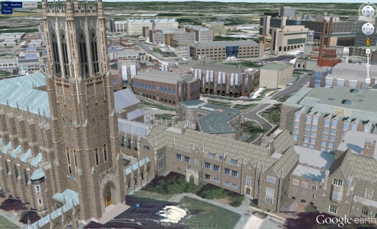
Back in May, Google Earth for Android was updated with 3D building support on tablets. Despite the additional load of the 3D buildings, the software continued to run remarkably smoothly and continues to be an amazing way to view Google Earth.

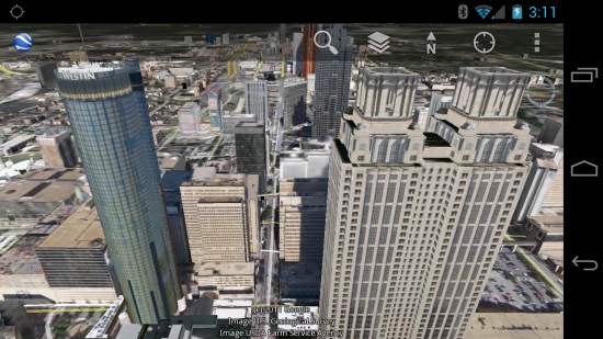
At the time, the 3D buildings didn’t show up on phones; it wasn’t even an option. However, on the Galaxy Nexus the 3D buildings are in there and they look great!

3d-buildings.jpg

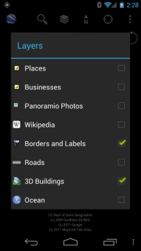
There was no update to Google Earth recently, and the buildings still aren’t available on my old phone (a Motorola Droid X), so presumably Google Earth looks at the hardware on your phone before presenting you with that option. If so, that seems like a wise move. Here is what the options panel looks like on the Galaxy Nexus:

settings.jpg

I don’t know what the minimal specs are offhand, but a dual-core processor seems like a good place to start. The Google Earth page in the Android market simply says “select phones”, so I don’t have a full list of compatible phones yet. As another added bonus, Google Earth came preinstalled on the phone; I’m quite sure that was not the case on the Droid X.

With the large, stunningly high screen resolution on the Galaxy Nexus (1280×720), Google Earth looks simply brilliant. More phones of this quality and beyond will be coming in 2012, which will make the mobile Google Earth experience even better.

An excellent 3D Campus Map in Duke University


Similar to other colleges we’ve shown you in the past, such as Northeastern University, Duke University has just unveiled their new 3D campus map and it’s quite impressive.


duke.jpg 

With the help of concept3D, the map has become an excellent source of information for the school. Powered by the Concept3D “CampusBird Atlas” CMS, Duke staff can edit the map and publish new information on their own. In addition, all data is mirrored between the Google Earth Plugin API and the Google Maps API on the site; it appears seamless to the end user, but it’s a tricky piece of work on the back end.

The map includes 3D models of 325 buildings across the campuses. The map also includes satellite views and traditional two-dimensional street maps and offers overlays that display details such as dining locations and parking permit requirements, photos related to the buildings and videos linked to specific campus locations.

The maps are only accessible via the Plugin (no downloadable KML), and you can view the new map here on the Duke website. In addition, the map is fully functional on mobile devices.

SketchUp: Models into real buildings


Over the years, we’ve talked quite a lot about SketchUp, Google’s amazing 3D modeling tool. Ultimately, though, many of these models are intended to become real buildings, so how well does the finished product match up to the original model? Google wants you to show them.


SteveOles.jpg 

As they recently posted, they’re encouraging you to send in your SketchUp stories; a SketchUp model accompanied by a photo of the finished product.