Android Developer Challenge, Sub-Saharan Africa!

In the past year alone, we have met with over 10,000 developers and techies across Sub Saharan Africa. We are continually impressed by the ingenuity and enthusiasm of this community in solving real problems with technology. From applications that crowd-source traffic info to mobile registration of local businesses, handheld devices have taken center stage for consumers and developers in Africa. With a number of countries in the region hovering around 80-90% mobile penetration, mobile is the screen size for the web and the communication experience.

Correspondingly, at every Google event in Africa, Android is the hottest topic; we know why. Every day over 300,000 Android devices are activated globally! A growing number of these mobile devices are powering on for the first time in emerging markets like those in Africa. As Android users multiply, so does the appeal to for developers of building apps on this free open-source platform.

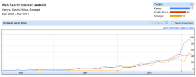
An increasing number of users are searching for ‘Android’ on Google in Sub-Saharan Africa

For all these reasons and more, we are proud to be launching the Android Developer Challenge for Sub-Saharan Africa!

The Android Developer Challenge is designed to encourage the creation of cool and innovative Android mobile apps built by developers in Sub-Saharan Africa. Invent apps that delight users and you stand a chance to win an Android phone and $25,000 USD. To get started, choose from one of three defined eligible categories (see below), build an Android app in a team or by yourself, and submit it via the competition website by July 1st. The winning app will be announced on September 12th at G-Kenya. Get more details as well as Terms and Conditions on our site.

Categories for Entry:

  • Entertainment / Media / Games
  • Social Networking / Communication
  • Productivity / Tools / Lifestyle

(See Terms & Conditions for more details!)

To launch this competition, we have teamed up with Google Technology User Groups (GTUGs) across Africa to host Android Developer Challenge events. Check out our website for Android gatherings near you, and get coding!
The WaterAid Point Mapper, helping find fresh water

As we’ve discussed a few times, water is a remarkably scare resource in many parts of the world, and Google Earth has proven to be a great way to learn more about the problem. A great example is the UNICEF: Water and Sanitation layer that was released a few years ago.

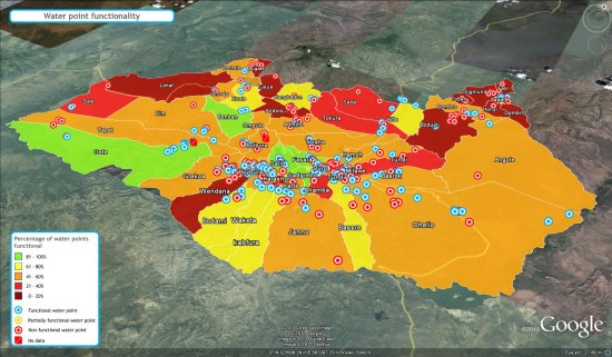
The folks at WaterAid have recently developed a Mapping tool called the Water Point Mapper. It takes data via Microsoft Excel and uses macros to generate KML files. The tool is now widely used by WaterAid country programs and partner organizations across sub-Saharan Africa to map rural water points. The tool empowers communities to manage their water sources and offers district level planning and resource allocation.

The Mapper can generate a range of point based and area based maps for monitoring a wide selection of status indicators. The list includes water source coverage (with and without functionality), functionality, water source type, revenue collection and access distance. Also a range of water quality parameters can be mapped, such as fluoride and iron. It can be configured for use in any country, as long as you can provide them with the necessary shapefiles for district and sub-district administrative levels.

There aren’t any sample files on the site, but they were kind enough to produce a few of them for us that you can check out. The first is a fairly standard map (KMZ file):

water-points.jpg

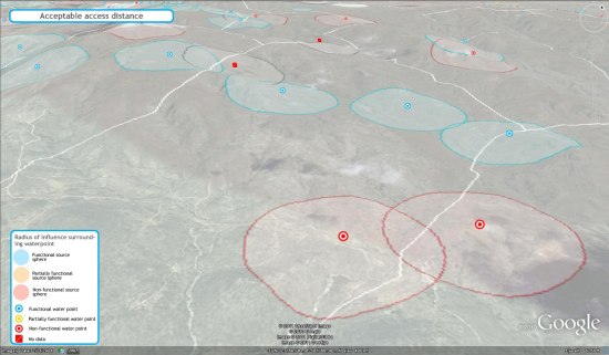
The next is a map that features “radius of influence” spheres, so you can see how much area each specific water distribution point is able to affect (KMZ file):

access-distance.jpg

For more info, check out their site at www.waterpointmapper.org.

In Africa, citizen cartographers tell their stories through their maps


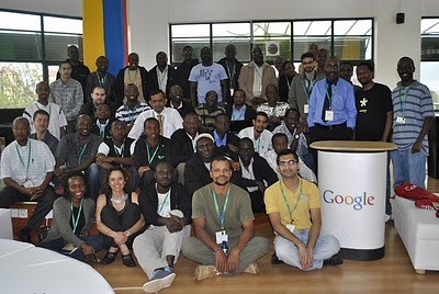
Earlier this month, we invited 60 of Google Map Maker’s top users in Africa to a community workshop in Nairobi. The event celebrated the contributions of exceptional mappers from across Africa who have collectively mapped hundreds of thousands of roads, cities and buildings, covering more than half the population in Africa. Participants from places including Burkina Faso, the Democratic Republic of Congo, Ethiopia, Gambia, Kenya, Morocco, Uganda, Rwanda, and Tanzania came together for this unique and inspiring opportunity to tell their stories, learn from each other, and share their mapping experiences using Google Map Maker. Check out the the Super Mappers Conference site for more details.


Meeting these passionate online mappers inspired all of us to think not only about creating maps to fulfill a practical need, but also about why we map and the deeply personal stories a map can tell. During these two days, we traveled to places that we perhaps may never see in person, but now mean more to us when we see them on a map because of the stories of mappers such as Noé Diakubama.

Noé grew up in the Democratic Republic of Congo (formerly Zaire), a country that has suffered many years at war. He is now living in Belgium and proud to give back to his country and people via mapping.

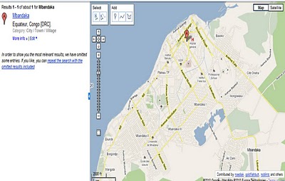
His mapping story began in Mbandaka, where he grew up. Noé liked to walk. Walking was about exploration and discovery. And Noé had many places to go, including secret spots to find wild vegetables and the EALA botanical garden. But without a map it was easy to get lost, so he could never wander too far from home. With his uncle, Noé sketched a small paper illustration of Mbandaka and its landmarks – that was his first experience with mapping! A few years later, he was surprised to find Mbandaka poorly represented on Google Maps; it only showed the city airport and two roads. Using Google Map Maker, he began mapping the roads by himself, and then asked friends and family to help him with adding local roads, their names and so on. Together, they created the first map ever of Mbandaka!


When I asked Noé why he maps, he replied:

Everyday, I spend hours and hours in front of my computer… mapping. My rewards include seeing a smile on the face of someone who sees for the first time the name of his/her street on the Internet, and knowing that someone benefited from the maps I created – kids journeying in the neighborhoods, business owners, or tourists. And ultimately, I want to see Africa being mapped and these maps made accessible to everyone. My message to other Africans: don’t be just a spectator, let’s all share our knowledge and start mapping cities and remote areas. We will soon, together, complete the mapping of our continent!

I’m used to seeing maps and thinking of them as a collection of edits or points of interests. It was an incredible feeling to personally meet and interact with the people behind the creation of the many dots on our maps. This was a gentle and welcome reminder that maps are not static. They’re alive, they’re personal, and they tell the stories of the people who create them. Mapping allows each of us to be a driving force for change and growth in both our immediate communities and the rest of the world. Let’s continue mapping, let’s stay connected through the Map Your World Community, and let’s continue doing amazing things together!

Posted by France Lamy, Program Manager, Google.org