The Stone Mountain sculpture


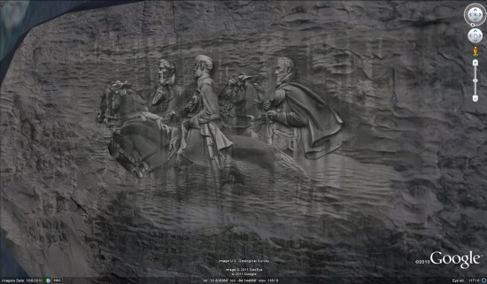
stone-mountain.jpg 

The carving on the mountain is widely thought to be 190 feet x 90 feet, provided by their official website as well as on Wikipedia. However, based on measurements made in Google Earth, Peter believed the actual size to be closer to 167′ x 77′. After repeated inquiries, Stone Mountain Park was able to confirm the actual size of the carving at 158′ x 76′ — even smaller than he had suggested (though still quite massive).

It’s also widely advertised that the total cutout on the mountain covers 3 acres. As it turns out, the cutout are is roughly 359′ x 191′ which amounts to 1.57 acres.

Peter’s new model just recently went live in the 3D Warehouse, so you can use this KML file to fly there and see it in Google Earth.

New 45° imagery available for 35 more cities

In Córdoba, the third largest town in the Spanish region of Andalucia, you can now explore in highly resolved images from four directions. Check out the world famous Mezquita-Catedral, a former mosque from the times when that part of Spain was ruled by the Moors, now a Roman Catholic Cathedral. Its construction as a mosque began around 800 and it was turned into a church after 1200.
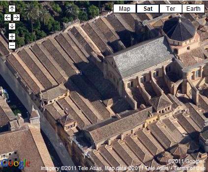


View Larger Map


A major update in the U.S. comprises Houston, the largest city of Texas and fourth largest of the United States. Take a look at the Houston Ship Channel with all its refineries and oil tanks alongside, erected for one Million Dollars in 1902 when oil was first discovered in the area.

View Larger Map


If you like sports you’ll be interested in the Rice University’s athletics stadium west of downtown or the Toyota Center, used by the Houston Rockets basketball and the Houston Aeros hockey teams.

Or take a look at William P. Hobby Airport just southeast of the city center which was the former main hub even for international flights. Nearby the largest American flag can be seen on top of a building.
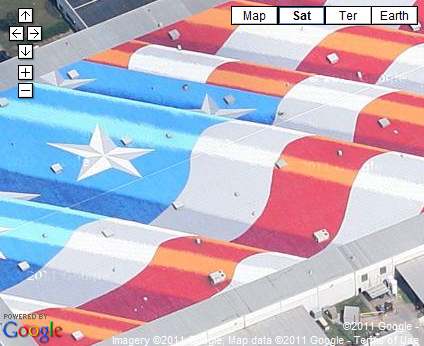


View Larger Map


Full list of updated cities:

Augsburg, Germany. Barstow, CA. Bartlett, TX. Big Bear, CA. Blackstone, VA. Catalina Foothills, AZ. Córdoba, Spain. Delano, CA. Desert Hot Springs, CA. Richmond, VA. Elgin, TX. Healdsburg, CA. Helendale, CA. Hemet, CA. Houston, TX. Mendoza, Argentina. Midlothian, VA. Napa Valley, CA. New Braunfels, TX. Ojai, CA. Ottawa, Canada. Pensacola, FL. Porterville, CA. Plant City, FL. Rancho Del Lago, AZ. Rosario, Argentina. Santa Clarita, CA. Sarasota, FL. Taylor, TX. Temecula, CA. Treasure Island, CA. Troy, IL. Twentynine Palms, CA. Wakefield, VA. Yucca Valley, CA.
PilotPak: Databases for the entire aircraft, for a single annual price

Aviation databases in the cockpit just became more affordable! PilotPak is our newest offering that allows our customers to buy a bundle of databases for select Garmin panel mount avionics, all at once and for a single annual price. Not only that, the purchase of a PilotPak will provide databases for all of your Garmin equipment in the cockpit. The databases within the selected package can be used with any combination of GTN™, G600, G500, G500H and G3X installed in one aircraft. Each bundle option includes Garmin’s popular SafeTaxi®, Obstacle, Terrain and Airport Directory, and customers are able to choose between bundle options that include Jeppesen NavData, Jeppesen JeppView and/or Garmin FliteCharts®.


The more Garmin avionics you have, the more you save! For example, with a PilotPak Standard Americas subscription, you can enjoy 20 percent savings on databases for a single GTN or 60 percent savings with the inclusion of a G500 when compared to purchasing annual subscriptions to each database individually. When Garmin’s FliteCharts are included, the savings on databases for a single GTN 750 amount to over 30 percent and when combined with a G500, you save over 70 percent.