Bing Maps now using Nokia Backend services for Traffic and Geocoding

Last year, Microsoft announced a strategic partnership with Nokia in Mapping. Our two companies have spent a lot of time working together, sharing information and investigating better ways provide relevant mapping information to help you find and get to where you’re going more quickly. Today, we’re excited to announce another important phase in that partnership with the launch of Nokia powered traffic results, which are rolling out today in 24 countries on Bing Maps.

The following countries will see improvements through Bing Maps as a result of our use of Nokia services:

· Austria

· Belgium

· Brazil

· Canada

· Finland

· France

· Germany

· Greece

· India

· Indonesia

· Ireland

· Italy

· Luxembourg

· Mexico

· Netherlands

· Poland

· Portugal

· Russia

· Saudi Arabia

· South Africa

· Spain

· Sweden

· Switzerland

· UAE

· United Kingdom

· US


New countries with Traffic

Sao Paulo, Brazil (Resize)

São Paulo, Brazil

Johannesburg, South Africa (resize)

Johannesburg, South Africa

Moscow, Russia (Resize)

Moscow, Russia

Mumbai, India (Resize)

Mumbai, India


Improved Traffic


We’re also improving our existing traffic coverage in the US to include traffic information for side streets in addition to freeway traffic information. See below for enhanced coverage in Seattle.

Seattle Side Street (Resize)

Seattle, Washington

In addition to these traffic improvements, Bing Maps will also start to use Nokia’s geocoding services in a number of countries offering improved directions.  This update, while not always visible to users, is another important milestone in our partnership to build the world’s best mapping platform using Nokia and Microsoft’s assets.

Thanks to our friends at Nokia for their dedication along the way. Together we have enabled a stronger Bing Maps experience and we hope Bing users in these respective countries reap the benefits of our partnership, notice an increase in address search relevance, and enjoy the addition of traffic information – especially those of you in the US who are adventurous enough to travel during the Memorial Day holiday!


Travel as a Roman

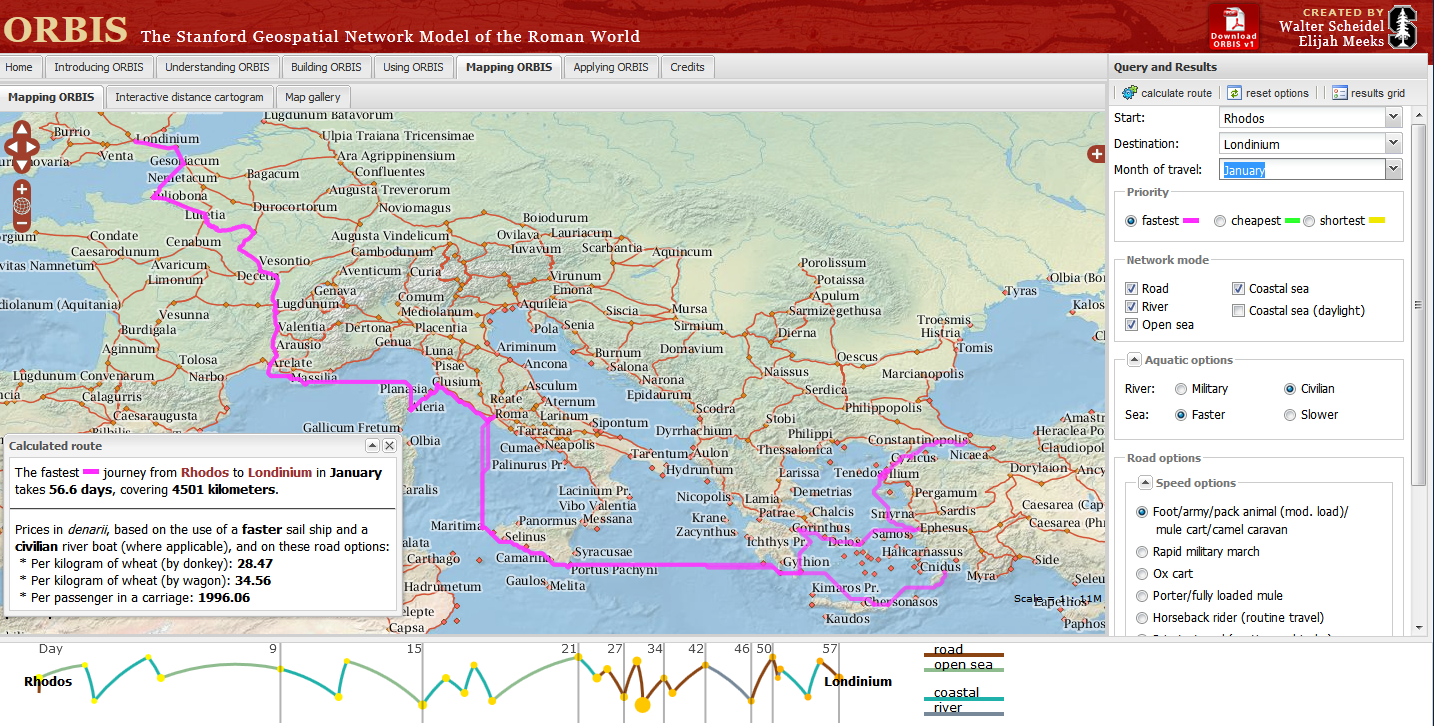
Stanford University have created a “Geospatial network model of the Roman world”
Impressive Interactive Map that can calculate  travel times and cost (in Denarius)
ORBIS, can calculate journey times between 751 locations in the Roman world. The site draws data from The BarringtonAtlas of the Greek and Roman World which has  been georeferenced by Cambridge University Students. To calculate voyages on water, the site uses maps of rivers. Sea journeys are also possible, with routes calculated from the Romans’ preferred sea routes. Dijkstra’s pathfinding algorithmis applied to calculate routes.
The Mapping tool also calculates route dependent on the month for a journey, as weather conditions at sea and on land had a major impact on ancient travel times.
Users can choose from a menu of transport/travel options:
  • Foot/army/pack animal, mule cart/camel caravan
  • Military March (Rapid)
  • Ox & cart
  • Fully loaded mule
  • Horseback rider (routine travel)
  • Private travel (routine, vehicular)
  • Private travel (accelerated, vehicular/horseback)
  • Fast carriage
Try the Roman Travel Interactive Map:
Information on the Geospatial Technology used is see the section tabs:
Building ORBIS: Multi-modal network model via the Building ORBIS tab and selecting the Geospatial Technology Tab.
via:mapperz.blogspot.com

iOS 6 dropping Google Maps for an in-house solution


It’s been rumored for a while, and we won’t know for sure until this summer, but it appears that Apple is dropping Google Maps from the iPhone and iPad in favor of an in-house solution.

Over the past few years Apple has purchased companies such as Placebase, C3 Technologies and Poly9, and it’s thought that they’ve successfully combined those technologies in a way that works quite well on the iPhone.  The new 3D mode is thought to be coming straight from C3 Technologies, which has a pretty nice system.  Here is a mock-up from 9to5Mac that shows the potential difference between the old and new system:

The result of this would be quite interesting.  There is certainly a lot of potential for them to do some great things, and losing the Google Maps integration is likely step when you consider the competition between Android and Apple.