The Bing Maps Windows Presentation Foundation Control v1

Back in August, was announced the Beta for our Bing Maps WPF control. The uptake in the Microsoft Developer Community has been stellar and the feedback – immensely helpful. As a result and as promised to those across the Microsoft Developer Network, we’re officially releasing The Bing Maps Windows Presentation Foundation Control, Version 1.

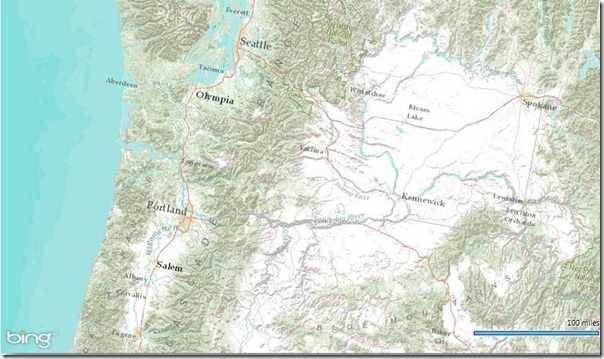
Bing Maps WPF Control with an ESRI Topographic Map Tile Overlay

The control was built atop of the beta, so we still have all of the touch enabled greatness for Surface v 2’s Pixel Sense, inertia and full rotation. We’ve kept most of the classes, methods and properties in place from the beta – requiring little work to install and register v1. And, per community feedback on the Bing Maps MSDN Forums we added the following features (and fixed a few bugs):

  1. Support for tile layers – you can now overlay your own tile layers atop the map control.
  2. Turning off the base tile layer – this is useful for when you don’t need/want to use our base map tiles and instead would prefer to use your own without overlaying them atop of ours. The control won’t request the tiles which reduces downloads and improves rendering performance.
  3. SSL Support – since many of you are using the WPF control in secure applications, you can now make tile and service request over SSL without issue.
  4. Hiding the scale bar – if you don’t want a scale bar (perhaps your map is small and the scale bar clutters the map) you can turn it off. In fact, the only elements you can’t turn off are the Bing logo and the copyrights.
  5. New copyright service – provides accurate copyright for our data vendors.
  6. Additional inertia – inertia is now enabled for the mouse and is on by default for touch.
  7. Miscellaneous bug fixes – thanks for the feedback on the MSDN Forums, the Bing Maps Blog, e-mail and Twitter. Good finds people.

I have to give it up for my (small) crack team of people involved in the making of the WPF Control. This was one of those 10% projects that we all really had a passion to get done because it was the right thing to do for the Microsoft Developer Community. So, we found the time, slipped the release a month (for quality) and, as the guys over in Surface said, “just got it done.” Our internal motto kept stoking the fire to push this bad boy out the door…”WPF, FTW!”

Now, download the Bing Maps WPF Control, build a killer app and make us proud.
Gallery of Inappropriate Bubble Ads


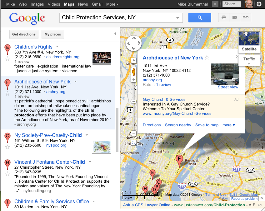
This search for “Child Protection Services, NY” provides an obvious example of Google’s inability to target a specific ad against a specific place with their new Info Bubble Ads.

There is some irony that the Archdiocese of New York* is sandwiched between Children’s Rights and the NY Society for the Prevention of Cruelty to Child in the Map search results and I suppose the bottom ad for a Child Protection Lawyer is somehow oddly relevant in this context.

But the ad for the Gay Church service shown against the Archdiocese manages to clearly demonstrate Google’s (lack of ) ability to target these ads correctly. It adds fuel to the already inappropriate fire that is the Bubble Ad… I never knew that the Adwords algo had such a twisted  sense of humor.

In attempting to match a single ad to a single Place in Google Maps raises multiple issues…..

1)Certainly business (and churches & political organization for that matter) have a new arena where they need to worry about reputation management. They now have to think about “defending” themselves against ads from competitors or groups that disagree with their position….This drives ad growth and is likely to drive up bid prices for Google. While this occurs for all the wrong reasons I believe that they ones of which Google is likely aware. I had heard rumors in early September of Adword Account Reps instructing large Adword clients to take out ads in Google Maps in anticipation of this rollout.

2)The algo is incapable of correctly understanding which Places should have ads and which shouldn’t. This makes every Place in the virtual universe a target for an ad. Churches which are in theory a sanctuary from commercialism lose that… somber memorials become just another opportunity for a pitch.

3)Content that is abhorent or antithetical to the Place in real life can be associated with the Place virtually. The algo does not posses any ability to distinguish relevancy at a granular enough level to provide truly relevant ads that respect the intentions and aspirations of a given place. But worse, ads that are totally inappropriate by most human standards become acceptable.

4)At the end of the day, many of these ads are disrespectful of the user that made the effort to dive deeply into Google and find out more information about a given place.

There is the argument that the low visibility of the ad location somehow obviates the offense. My experience with Google Maps is that it is a testing ground for the big show. Single ads against single Places will migrate outward and upward if they are successful within Maps.

Like Facebook is pushing the limits of privacy in an effort to have none, Google is pushing the limits of ad display so that there are no societal limits on where or when ads can be displayed. Clearly breaking down societal mores that provide implicit boundaries to advertising is in Google’s best interest. I am not sure that it is the interest of either the general public nor the small business community.

*Note that I have no love lost on the Archdiocese of NY and they certainly have only themselves to blame for any problems that they have. That doesn’t deny my belief that they, and any church for that matter, should not have to worry about how Google uses their info bubble.

Captain James Cook’s circumnavigation of New Zealand

Back in the mid-1700’s, Captain James Cook made a variety of discoveries around the world including the first European contact with the eastern coastline of Australia and the Hawaiian Islands. In addition, he recorded the first circumnavigation of New Zealand.

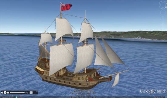
Colin Hazlehurst has put together an amazing tour of Cook’s circumnavigation, featuring an excellent 3D model of his ship, constructed by Phillip Müller.

ship.jpg

To see it for yourself, you can download this KML file.

Here’s a brief overview of Cook’s journey, taken from the KML file:

His Majesty’s Bark Endeavour sailed from Plymouth on Friday, 26Aug1768 with Lieutenant James Cook as Commander. The mission of the Endeavour was to boldly go…oh no that’s Kirk not Cook.

The first objective of Cook’s voyage was to observe the transit of Venus from the island of Tahiti in June, 1769, and after that to explore the Pacific with a view to determining whether or not there was a large southern continent.

At 2 p.m. on Saturday, 7th October, 1769, land was seen from the masthead of Endeavour bearing west by north; this was the North Island of New Zealand and James Cook gave the order to stand in for it.

The ship anchored in Poverty Bay in the afternoon of 8th October, yet it took another four months to complete the circumnavigation of the island.

From Poverty Bay, Cook first took the Endeavour southwards along the coast as far as Cape Turnagain, where he decided it would be more fruitful to explore to the northwards. By meticulous observation of the sun, moon, and stars, Cook charted the coastline, noting the hazards to shipping and the places where there was safe anchorage and plentiful wood and water.

Always along the way, he tried to befriend and trade with the people he met, though not every encounter was successful. There were well-armed, warlike people who lived in strategically placed strongholds, but also friendly and curious people who were happy to trade fish and other seafoods for cloth and nails. Cook always regretted the taking of life, but sometimes it was necessary in self-defence.

He rounded East Cape on 31Oct1769 and made his way along the coast in a broadly north-westerly direction. He made extended visits to the Bay of Islands and Mercury Bay, this last so named because they observed the transit of Mercury, and so were able to fix the latitude and longitude of the bay to a high degree of accuracy.

It took more than 3 weeks to round North Cape, in the face of westerly gales, strong currents, and a broad swell. Cook found it impossible to land on the ‘dangerous’ west coast of North Island, finding no safe harbour or anchorage. He rounded Cape Egmont and made his way to Queen Charlotte Sound where the ship was careened and scrubbed.

After narrowly avoiding the small islands called The Brothers, Cook took Endeavour through Cook Strait and started to explore the east coast of South Island. However, to prove to his officers that North Island was indeed an island and not part of a larger continent, he took advantage of a favourable wind to complete the circumnavigation of North Island on 09Feb1770.

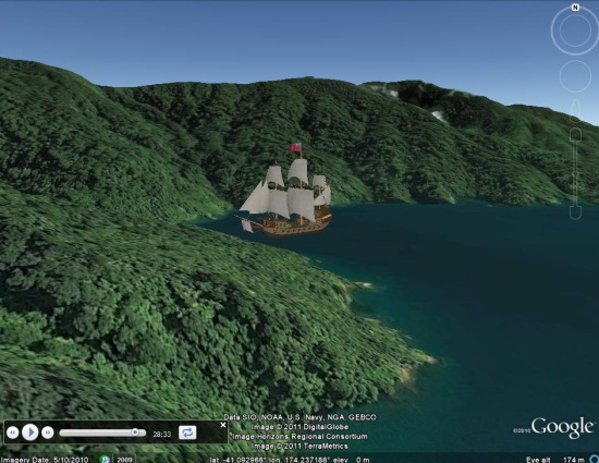
ship2.jpg

In Colin’s words, here’s how the file itself works:

This Google Earth presentation animates the 3D model of a ship as it follows the track of the Endeavour, and is accompanied by a reading of Cook’s journal. The circumnavigation of North Island is divided into sections which have significant start and end points. In Google Earth terminology, each section is known as a ‘tour’.

To play a given tour, first find it in the Table of Contents folder. You will see the name of each tour displayed as a hyperlink against a Folder icon, e.g. Poverty Bay to Cape Kidnapper. A single click on the hyperlink will display an information balloon which shows, for that tour:

• The start and end dates of the journey.
• The duration of the tour in minutes and seconds, being the length of time it will take to play the tour in Google Earth.
• Start a tour by expanding the Folder to show the Tour icon and the title ‘Play’ and double-clicking the icon.

via: Google Earth Blog