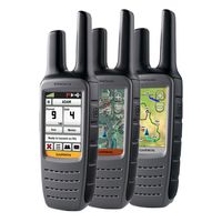
 Rugged communication at its best – the redesigned and upgraded Rino®610, 650 and 655t handheld two-way radios integrated with GPS. Boasting up to a 20-mile communication range the Rino 650 and 655t 5-watt FRS/GMRS radios have evolved to include a 2.6” glove-friendly touchscreen and are packed full of powerful features like a barometric altimeter, 3-axis tilt compensated compass and NOAA weather radio. The Rino was announced in preparation for the Teva Mountain Games in Vail, CO, where it will be prominently displayed at the Garmin booth June 3-5.
“Whether you’re a hunter looking for peace of mind in the woods, a ski patroller monitoring conditions in the Rockies or simply want to enjoy the outdoors with the benefit of radio communication and GPS, the new Rino has what you need,” said Dan Bartel, Garmin’s vice president of worldwide sales. “Having the ability to know where someone is in your hunting group at all times and to communicate freely with them provides a new level of safety only found from Rino.”
Turn On and Go: Each device in the Rino series has a high-sensitivity GPS receiver with HotFix®, which automatically calculates and stores critical satellite information and can use that information to quickly calculate a position so you can spend more time active and less time waiting. And with multiple profiles like Marine, Recreational and Automotive to name a few, Rino can be customized to match whatever activity you might be performing. To see Rino in action visit, www.garmin.com/rino
Value Minded: Garmin’s Rino 610 is an entry level 1-watt FRS/GMRS radio handheld GPS radio is powered by four AA batteries, lasts up to 18 hours and comes pre-loaded with a worldwide basemap. With its spacious 1.7GB of internal memory Rino makes it easy to add maps with its wide array of detailed topographic, marine and road maps. Rino 610 lets you load TOPO U.S. 24K maps and hit the trail or BirdsEye Satellite Imagery (subscription required), which lets you download satellite images to your device and integrate them with your maps. In addition, Rino 610 is compatible with Custom Maps, free software that transforms paper and electronic maps into downloadable maps for your device.
Share Wirelessly: With Rino 650 and 655t, you can share your waypoints, tracks, routes and geocaches wirelessly with other compatible Garmin GPS devices. Once your Rino is connected via USB, download BaseCamp™ software (www.garmin.com/basecamp) to easily store and share your photos. BaseCamp also helps you view, plan and organize your maps (in 2D or 3D), waypoints, routes and tracks – including elevation profiles – and send them to your Garmin handheld.
Document Your Journey: Never miss a memory with Rino 655t’s built-in 5-megapixel autofocus camera; you’ll be able to capture the highlights of your outings. Each photo is automatically geotagged with the location of where it was taken, allowing you – or those you share your photos with – to easily navigate back to that spot in the future. Along with its camera, Rino 655t comes pre-loaded with TOPO 100k maps.
The new Rino devices are expected to be available in the third quarter of 2011. The Rino 610 and 650 have a suggested retail price of $349 and $499.99, respectively. The Rino 655t has a suggested retail price of $599.99. Additional information about the Rino series is available at www.garmin.com or www.garmin.blogs.com. Garmin has spent more than 20 years developing technologies and innovations to enhance users’ lives, making it a household name in the automotive, aviation, marine, wireless, outdoor and fitness industries.

