The Weird Terrain Layers

Google Earth terrain snafu


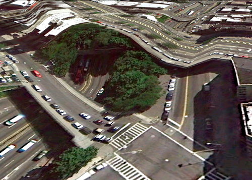
Clement Valla collects instances where Google Earth’s 3D terrain layer doesn’t play well with the satellite and aerial imagery — elevated highways and bridges, for the most part. The effect is redolent of Dali — and it’s what happens when you try to make a 3D model of 2D imagery of a 3D surface.

Mapping Social Networks

Facebook activity visualization

This map by Facebook engineering intern Paul Butler that shows activity and relationships between various locations around the world. “I was interested in seeing how geography and political borders affected where people lived relative to their friends. I wanted a visualization that would show which cities had a lot of friendships between them.” Via Boing Boing.

World Map of Social Networks, Dec. 2010

And this map shows which social network dominates in which country. Creator Vincenzo Cosenza has maps for previous months as well for comparison.

(via Gizmodo)