Bing Maps now using Nokia Backend services for Traffic and Geocoding

Last year, Microsoft announced a strategic partnership with Nokia in Mapping. Our two companies have spent a lot of time working together, sharing information and investigating better ways provide relevant mapping information to help you find and get to where you’re going more quickly. Today, we’re excited to announce another important phase in that partnership with the launch of Nokia powered traffic results, which are rolling out today in 24 countries on Bing Maps.

The following countries will see improvements through Bing Maps as a result of our use of Nokia services:

· Austria

· Belgium

· Brazil

· Canada

· Finland

· France

· Germany

· Greece

· India

· Indonesia

· Ireland

· Italy

· Luxembourg

· Mexico

· Netherlands

· Poland

· Portugal

· Russia

· Saudi Arabia

· South Africa

· Spain

· Sweden

· Switzerland

· UAE

· United Kingdom

· US


New countries with Traffic

Sao Paulo, Brazil (Resize)

São Paulo, Brazil

Johannesburg, South Africa (resize)

Johannesburg, South Africa

Moscow, Russia (Resize)

Moscow, Russia

Mumbai, India (Resize)

Mumbai, India


Improved Traffic


We’re also improving our existing traffic coverage in the US to include traffic information for side streets in addition to freeway traffic information. See below for enhanced coverage in Seattle.

Seattle Side Street (Resize)

Seattle, Washington

In addition to these traffic improvements, Bing Maps will also start to use Nokia’s geocoding services in a number of countries offering improved directions.  This update, while not always visible to users, is another important milestone in our partnership to build the world’s best mapping platform using Nokia and Microsoft’s assets.

Thanks to our friends at Nokia for their dedication along the way. Together we have enabled a stronger Bing Maps experience and we hope Bing users in these respective countries reap the benefits of our partnership, notice an increase in address search relevance, and enjoy the addition of traffic information – especially those of you in the US who are adventurous enough to travel during the Memorial Day holiday!


New 21 cities with 45° imagery

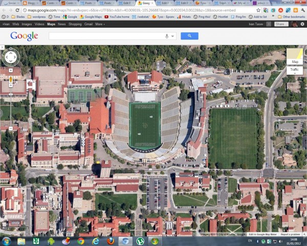
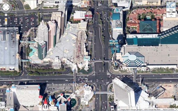
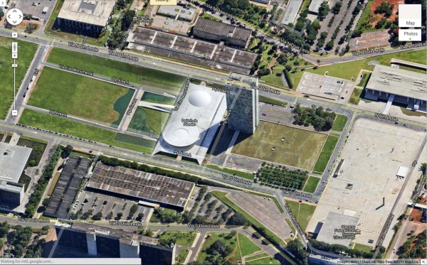
Viewing 45° imagery can make the map much more fun and informative by enabling you to see a tilted aerial perspective of some of your favorite spots. In this month’s 45° imagery update in Google Maps, I highlight one of my favorite towns in Colorado.

Boulder, Colorado is a mecca for outdoor hiking, cycling, and climbing excursions and 45° imagery can help users plan their adventures. Located at the base of the Rocky Mountains, Boulder is at an elevation of 5,430 feet (1,655m) above sea level which makes for fun terrain to look at from a bird’s eye view. Here’s an image of Folsom Stadium at the University of Colorado, Boulder:


The “Strip” in Las Vegas, Nevada is also included in the latest batch of 45° imagery. Now you can see the some of the large casinos and resorts that dot the famous Las Vegas Boulevard.

Next we head to the southern hemisphere to Brasilia, the capital of Brazil. The city sits high up on a plateau and some say the aerial view of Brasilia resembles an airplane. Now you can fly even closer and get a 45° look.

Here is a list of updated cities:

U.S.
Albuquerque (west), NM; Benton, AR; Boulder, CO; Eldridge, IA; Boston (east), MA; Centennial (south), CO; GooglePlex, CA; Indianapolis (south), IN; Las Vegas Strip, NV; Montgomery (outskirts), AL; Olathe, KA; Petaluma, CA; Tulsa, OK

South America
Brasilia, Brazil

The last imagery update was more than just Japan

A couple of days ago, we told you about some fresh imagery from Japan that Google had added to the base layer of Google Earth. At the time we assumed that the Japanese updates were the extent of it, but thanks to sharp-eyed GEB reader ‘Munden’ (and confirmation from the updated KML file), it turns out there was a bit more.

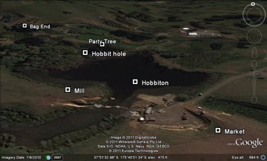
It wasn’t a major update, but there is also new imagery in parts of Austria, Brazil, Cuba, Ireland, New Zealand, Paraguay, Spain and Tanzania. It was the New Zealand imagery that caught Munden’s eye, as the update captured construction on the set of the upcoming movie “The Hobbit“. Details on that can be found over at Google Earth Hacks.

hobbiton.jpg

To see all of the areas that were updated, just grab the updated areas KML file and look for the red outlines.