Announcing New Bing Maps & Local Features: Interior Views, Enhanced OpenTable Integration, Real-Time Transit, and Streetside for Mobile

Throughout the last few months, Bing Maps & Local has focused on how our product can help with everyday decisions and deliver innovative experiences to a wide audience. The end result is a more functional, easier-to-use, and differentiated experience. The theme for this release has been around three areas: i) Delivering new types of visual detail, ii) Simplifying local tasks, and iii) Improving maps on mobile. With that in mind, today we’re announcing four new features we’re really excited about:

· Interior Views: Provides users with immersive 360-degree panoramas of local businesses
· OpenTable Integration: Lets users interact with OpenTable directly from restaurant pages
· Real Time Transit on Mobile: Gives users real time info if a bus is on-time or delayed
· Streetside for Mobile: Brings users street-level imagery + some mobile-exclusive enhancements

Interior Views

Have you ever showed up to a restaurant excited to try it for the first time only to be disappointed by its look and feel? Wouldn’t it be great if you could explore the inside of a restaurant just as you can explore the streets with Streetside? Reading reviews of what other people say about a place’s atmosphere is helpful, but you’re the real judge of whether a restaurant’s décor, size, and appearance fit what you’re looking for. And if a picture is worth 1000 words…well, each of our new Interior Views could make a very large book.

· Through a partnership with EveryScape Eats, Bing Local lets you “step inside” and explore full panoramas of restaurants.
· Interior Views are accessed by clicking on the “step inside” panoramic thumbnail on a Bing Local details page.
· Clicking the thumbnail opens the experience (built on Silverlight) and enables you to jump inside the restaurant, move from room-to-room, and explore 360-degree views.
· Current coverage is ~5,000 restaurants (majority Boston metro area) but will be expand continually for breadth and depth in more cities.

A few great examples are: CanlisDavide RistoranteGennaro’sIvy Restaurant

OpenTable Integration

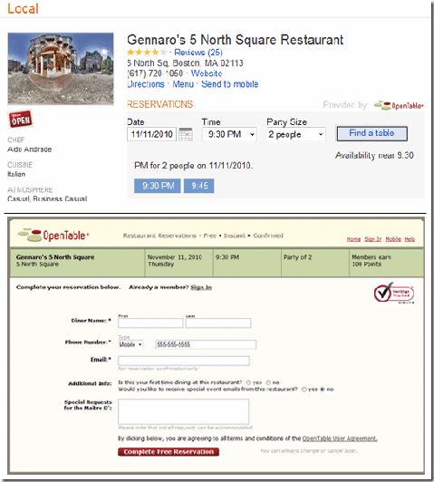
Our new Interior Views help you decide if a restaurant is the right place to go…so it only makes sense to better help you get a reservation. When you go to a local details page for one of the 15,000 restaurants signed up with OpenTable, you can now search for available reservations directly in Bing. Enter in the date, time, and party size and Bing pulls up what’s open. Click on a time you want and you’re brought to the page to finalize your reservation. Simple. To recap:

· Reservations through OpenTable are now available right on the local details pages.
· Every restaurant that is an OpenTable customer will have this functionality.
· Bing Local makes planning a night out easier and faster so you can spend more time on the important things (like what you’re going to eat once you get there!)

Real-Time Transit & Streetside for Mobile

At Bing, we want to help our users answer a lot of questions. Two of these questions are: “When is my bus really coming?” and “What’s the place I’m walking to look like?” With Real-Time Transit and Streetside added to Bing Maps on mobile, we can check those two questions off the list.

Real-time Transit for Bing Mobile on the iPhone adds up-to-the-minute data for Seattle, Boston, and San Francisco transit agencies. In one release cycle, Bing added transit routing and is now the first search engine to offer real-time transit information.

Streetside on Bing Mobile gives you the street-level imagery currently available on the desktop but with a few “enhancements.” If you pinch the screen to zoom out, the Streetside imagery will be stitched together so you can flick your finger and easily pan through streets. Also, the names of local businesses in the current street-level view appear under their respective buildings so you can learn more about what you’re seeing.

Below is a video to see Real-time Transit in action, but to learn more about the entire Bing Mobile release and see all the features and screenshots, head to the Bing Mobile Post.
Partner Webcast on Feb 17 – Hosting Geospatial Imagery in the Cloud

Good afternoon! In a few weeks, Kevin Adler, one of our Bing Maps Solution Specialists, will be hosting a webcast about geospatial imagery in the cloud and its positive impact on IT costs. If you’re interested, details are below:

Today’s economy is forcing government agencies to review every aspect of the business to find new ways of reducing expenses while maintaining service. Geospatial services and specifically imagery—which is the largest amount of data and often the most expensive —is no different.

Hosting geospatial imagery in the cloud reduces the total IT cost of infrastructure as it alleviates the need of owning and maintain servers, software, and staff time to deploy solutions that include geospatial imagery. For government agencies this can serve as a single source hosted in the cloud reducing the need to maintain local server farms.

You’re invited to attend this free webcast presented by Terra Pixel, a Microsoft partner, to learn how managing your agency’s imagery services in the cloud can save taxpayer spend. Using Image Patch Cloud Service from Terra Pixel allows users to securely manage geospatial imagery in the cloud and provide uninterrupted access to your imagery through Microsoft Bing Maps API as well as OGC web services WMS, WMTS, OSGeo, etc…

Attend this webcast and learn how to: i) Reduce the total overall IT infrastructure costs
ii) Use Cloud services from Microsoft to enhance redundancy, security and simplify the challenges of working with massive amounts of data and iii) Streamline the process of updating imagery and distributing it to your customers.

To learn more and to register, please see

https://msevents.microsoft.com/CUI/EventDetail.aspx?EventID=1032474264&culture=en-US

Bing Maps REST Services now supports transit routes!

The Bing Maps REST Services has added a transit travel mode so you can get transit routes and even display a transit route on a static map in your application.  All you need to know is  where you want to go and what time of day and then the REST Services will return a transit route based on your request.  To get a transit route, use the existing URL for getting a route and specify the travel mode as Transit. Then set the new dateTime parameter to a time value and set the timeType parameter to  departure, arrival or lastAvailable and let the Bing Maps REST Services do the work. Transit route steps can include walking instructions as well as transit information.

To see how this works, check out these examples:

(Note: To use each of these URLs,  you must set the key parameter to a valid Bing Maps Key. For information about getting a Bing Maps Key, see Getting a Bing Maps Key.)

Example #1: Get transit route information

What if you’d like to take transit from the Space Needle in Seattle to the Bellevue Square Mall in Bellevue at 3 PM in the afternoon today. Here’s the URL that will tell you how.

http://dev.virtualearth.net/REST/V1/Routes/Transit?wp.0=Space%20Needle&wp.1=Bellevue Square Mall&timeType=Departure&dateTime=3:00:00 PM&output=xml&key=YourBingMapsKey

Example #2: See a transit route on a static map

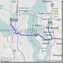
You can also view the route on a static map and zoom in to see details at the start and end of the route.

http://dev.virtualearth.net/REST/v1/Imagery/Map/Road/Routes/Transit?timeType=Departure&dateTime=3:00:00 PM &wp.0=Space Needle&wp.1=Bellevue  Square Mall&mapVersion=v1&key=YourBingMapsKey

Example #3: Walking to the bus stop from Seattle Center

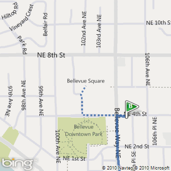
Note that a walking segment is displayed as a dotted line.

http://dev.virtualearth.net/REST/v1/Imagery/Map/Road/47.620495,-122.34931/15/Routes/Transit?timeType=Departure&dateTime=3:00:00 PM &wp.0=Space Needle&wp.1=Bellevue  Square Mall&mapVersion=v1&key=YourBingMapsKey

Example #4: Walking to Bellevue Square Mall from the bus stop

http://dev.virtualearth.net/REST/v1/Imagery/Map/Road/47.615635,-122.20435/15/Routes/Transit?timeType=Departure&dateTime=3:00:00 PM &wp.0=Space Needle&wp.1=Bellevue Square Mall&mapVersion=v1&key=YourBingMapsKey

Details on MSDN

This new feature is part of the Bing Maps REST Services. For details about how to get transit route information and how to display a route on a static map see the Calculate a Route and Get a Static Map topics on MSDN.