Ingres Db

The latest version of Ingres relational database now also includes support for geospatial data. GIS functions and spatial data types are included out-of-the-box (i.e. do not require additional plug-ins) and make it easy to enable web mapping. Ingres 10S supports spatial applications, such as Esri’s ArcGIS for Desktop and FME but also MapServer and GeoServer.

Ingres 10S is supported by other programming libraries including GDAL/OGR and GeoTools, allowing import, export and manipulation of vector data. Ingres 10S leverages the GEOS geometry and PROJ cartographic projection libraries for manipulating and transforming spatial data between dozens of geographic and planar co-ordinate systems.

Ingres 10S is an open source, enterprise grade database, not as popular as MySQL or PostgesSQL but, as the other options, can be downloaded and used for free. Ingres was first created as a research project at the University of California, Berkeley in the early 1970s. Since the mid-1980s, Ingres has spawned a number of commercial database applications, including Sybase, Microsoft SQL Server, NonStop SQL, but also open source PostgreSQL (which with PostGIS extension is the most popular open source spatial database).

The New Google Earth Imagery – February

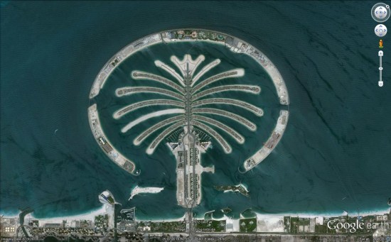
Google has just pushed out a fresh batch of new imagery to a variety of places around the world.

dubai.jpg

Due to the new “Pretty Earth” imagery, it’s more difficult to spot fresh imagery. Also, the imagery this month arrived in Google Maps before Google Earth, which threw us off a bit. In any case, here are some of the locations that GEB readers have identified as having fresh imagery. Many of them were made aware of the new imagery via the Follow Your World notifications, which we certainly encourage you to sign up for.

Here is the list of updated areas we know about so far:

  • Canada: Villeneuve
  • Italy: Vernazza
  • Romania: Deva
  • Spain: Villacariedo
  • United Arab Emirates: Dubai
  • United States: California (Chino, Eureka), Illinois (Decatur), Louisiana (Alexandria), North Dakota (Minot), Tennessee (Johnson City, Kingsport)

Google Earth: 3D trees in Portland, Oregon


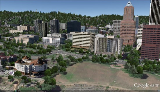
Thanks to sharp-eyed GEB reader ‘Donovan’, it appears that Google has just released thousands of 3D trees in Portland, Oregon (and possibly some other cities).


portland-trees.jpg 

When Google Earth 6 was released, they included 3D trees in San Francisco, Chicago, New York, Athens, Tokyo and Berlin. In March they added trees to London in preparation for the royal wedding. In June, they added trees to Philadelphia, Boston, London and a few other cities in the California Bay Area. They followed that up in September with trees in Boulder, Denver and Los Angeles. Now we have Portland.

The tree releases have been fairly spread out, but this update comes barely a month after the previous release, so hopefully they’ll be rolling these updates out at a more rapid pace.

Google hasn’t officially announced this release, so there could be additional cities in there as well.