The new interactive SDK for AJAX 7.0

As many of you know, we recently rolled out some updates to the AJAX Control 7.0 (and we apologize to those of you who experienced problems with that, if you are still seeing issues please visit our developer forum to find solutions and report issues).

We’ve also just launched an interactive SDK for our AJAX Control 7.0. This handy developer resource is a great way to check out features and easily find the corresponding code and events for use in your applications.  The left hand nav shows you all of the major features in the SDK, while the body of the page shows you the feature in action with the (editable!) source code right below.
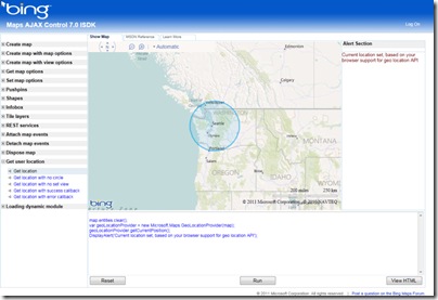

On the right, alerts and events info is displayed.

Want to check out what’s new with the AJAX Control 7.0?  Try the following:

  • Create map with map options > Map with inertia intensity: Try varying the inertiaIntensityparameter in the source code window. Set it anywhere between 0 and 1, hit run, and then see what happens when you click and drag the map.
  • Create map with map options > Map with background color: Pull the fully zoomed out map down to see the background color and hit the “Run” button. This shows off the new backgroundColoroption and gives you a random color every time. Try typing in your own RGB values and see what you get.
  • Get user location > Get location: If the browser on your phone or PC supports the W3C GeoLocation API, then try out the new getCurrentPosition method to easily find yourself on the map. (Note that the accuracy of this function varies depending on the capabilities of the requesting client. For example, desktop users may see lower accuracy while mobile users see much higher.)
  • Loading dynamic module > Load module – clustering: This shows you how you can use the new module loading methods to register and load your own custom modules (or modules built by other Bing Maps developers).

You can find this new interactive SDK here and a list of what’s new with the AJAX Control 7.0here on MSDN.  We hope you find this a useful tool!

Now 3D buildings in Google Earth for Android tablets!

Google Earth on mobile devices just took a big step forward with the release of Google Earth 2.0 for Android, with a special emphasis on tablets. It has some great new features, but is still lacking some of the features that we were hoping for.

The big addition to this release is 3D buildings! Every 3D building that you can view on your desktop is now available on your Android tablet. The buildings use the same high quality texture as the desktop version, though there’s no anti-aliasing built-in so things can look a bit choppy around the edges.

Curiously, it doesn’t appear to load any of the gray buildings from Google Earth — only the ones that are textured. Nor do any of the new 3D trees load, though that’s not a big surprise at this point.

In addition, they’ve worked on the “action bar” at the top of the screen to make it easy to search for locations, toggle layers, reorient yourself, etc. It’s very well done.

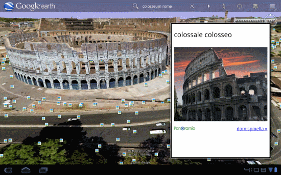
Other nice new features include the new content pop-ups when viewing items like photos, as shown here:

colosseum.png

The photo feature is nice, but it’s difficult to view the picture full-size. Rather than clicking the photo itself, you need to click the small Panoramio link below it. Not very intuitive, though the overall photo viewing experience is quite nice.

In terms of performance, it certainly doesn’t run quite as smoothly when you’ve got the buildings enabled, but it holds up quite well. Much of that will be based on the capabilities of your tablet, but the Xoom with its dual-core processor handles things quite well. It’s very apparent that they worked hard to optimize performance on this version.

The only real downside is that they’ve ignored most of Frank’s list of things the tablet version should have, specifically KML support. Having some degree of KML support on the tablet version would be quite nice, and I’m sure we’ll see it someday. We believe that the new Android tablets are fully capable of supporting all of the features from the desktop version, and it’s a matter of Google taking the time to port those features over.

If you have a Xoom, or one of the other few Android 3.0-enabled tablets, give it a shot and let us know what you think!

ArcGIS Server 10.1 Is 64-Bit Only, MSDs Over MXDs, and What About ArcInfo Workstation 10.1

In the ArcGIS 10 depreciation document this little tidbit catches my eye.

ArcGIS Server 10.1 will no longer support 32-bit operating systems. ArcGIS 10.1 will exclusively support 64-bit operating systems. Support for 64-bit native execution across all the tiers of ArcGIS Server has been a long awaited feature by many of our customers. 64-bit hardware is the norm in today’s market and most modern ArcGIS Server deployments do in fact run on 64- bit hardware. ArcGIS Server 10.1 will run as a native 64-bit application exclusively requiring 64- bit capable hardware.

Now we are talking about Server here, not Desktop, but a total 64-bit server suite is very nice.  One more thing that for some reason seems to get people a bit riled up:

ArcGIS Server 10.1 will no longer support publishing non-optimized map documents (MXD files). ArcGIS 10.1 will only support publishing optimized maps (MSDs) as that is the best practice for map publishing. At ArcGIS Server 10.1, optimized map services (MSDs) will be enhanced to support many of the capabilities that are currently only available through MXD-based map services.

This is a total performance change now that MSDs will support just about everything you need from a cartographic standpoint.  Oh and one last little tip of the hat to the workhorse:

There are no plans to release a new version of ArcInfo Workstation at ArcGIS 10.1.

Frozen in time will ArcInfo Workstation be (hmm did I just channel Yoda there?).

I suspect there will be no fighting over any of the above…