The RHoK community

Two years ago representatives from Google, Microsoft, Yahoo!, Hewlett-Packard, NASA and the World Bank came together to form the Random Hacks of Kindness (RHoK) program. The idea was simple: technology can and should be used for good. RHoK brings together subject matter experts, volunteer software developers and designers to create open source and technology agnostic software solutions that address challenges facing humanity. On June 4-5, 2011 we’ll hold the third Random Hacks of Kindness global event at five U.S. locations and 13 international sites, giving local developer communities the opportunity to collaborate on problems in person.

The RHoK community has already developed some applications focused on crisis response such as I’mOK, a mobile messaging application for disaster response that was used on the ground in Haiti and Chile; and CHASM, a visual tool to map landslide risk currently being piloted by the World Bank in landslide affected areas in the Caribbean. Person Finder, a tool created by Google’s crisis response team to help people find friends and loved ones after a natural disaster, was also refined at RHoK events and effectively deployed in Haiti, Chile and Japan.


We’re inviting all developers, designers and anyone else who wants to help “hack for humanity,” to attend one of the local events on June 4-5. There, you’ll meet other open source developers, work with experts in disaster and climate issues and contribute code to exciting projects that make a difference. If you’re in Northern California, come join us at the Silicon Valley RHoK event at Google headquarters.

And if you’re part of an organization that works in the fields of crisis response or climate change, you can submit a problem definition online, so that developers and volunteers can work on developing technology to address the challenge.

Visit http://www.rhok.org/ for more information and to sign up for your local event, and get set to put your hacking skills to good use.

Another natural disaster tragedy in Oz

I have just heard the news about flash flooding in Toowoomba and Lockyer Valley, Queensland. In this latest incident eight people died and so far over 70 are missing. Death toll is expected to rise. My heart goes out to all that have lost loved ones in this tragedy.
The overall death toll from floods in NSW and QLD in November 2010 to January 2011 is much higher but statistics are not readily available. As usual, after the clean up is finished questions will be asked: “Was this tragedy preventable?”. Then millions will be poured into a solution “…to prepare us for the next time”, as was the case with all previous disasters. So now Australia has a few hundred million dollar tsunami detection and early warning system to prepare us for another one-in-100-years event. As a result of Victorian bushfires we also have a multi million dollar monitoring and alert system (including phone messaging alerts) for bushfires. Flood warning system will be the next…
Why it always takes a tragedy to motivate governments to do something to improve safety of its citizens? The money is then no objective to find a better approach/ solution… Why can’t there be a proactive rather than reactive approach to disaster mitigation?

What I am about to say is not intended a as a criticism of authorities, rather just a statement of facts. Yes, it is obvious that a bit more proactive approach would save lives but the reality is that it is very difficult for authorities, whether State or Federal to do things proactively. Most often then not, priorities of the day take precedence (just read news headlines and it will become clear what this priority is on any given day). It takes lots of resources and time to get major projects off the ground, then administer them towards a particular outcome. Therefore, there must be a catalyst, a disaster if you like, to shake things up and get politicians to “find” those millions to put policies in place to prevent another similar tragedy.
Don’t get me wrong, not that there are no continuous improvements to current disaster mitigation programs, but still, it takes a disaster to focus the attention of decision makers on things that “should have been done in the first place”… Again, the reality is that Departments and agencies can only work on projects within their allocated range of responsibilities and currently allocated tasks, and money. All in all, it is very difficult for pubic service institutions operating in our existing governance structures to do things proactively, without aligning to specific agendas of the government of the day…

So, who else is there to look after the interests of individual citizens? I believe that community at large should accept part of the responsibility for looking after its own affairs. Even without huge financial resources public initiatives can make enormous impact. And with respect to prevention of disasters, communities can assist or complement things put in place with government funded programs. But there have to be a widespread commitment for things to work…

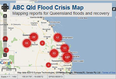
Just consider a few examples of community lead projects in GIS arena like, for example, OpenStreetMap community response to 2010 Haiti earthquake or Ushahidi community engagement after Haiti and Chile earthquakes. Australia has its own suite of natural disaster focused applications, either community based or maintained by enthusiasts. For example, ABC has just released ABC Qld Flood Crisis Map, built on Ushahidi platform, for crowdsourcing reports on Queensland floods and recovery operations. BushfireConnect is another community lead Ushahidi deployment for corwdsourcing reports on bushfires. Ushahidi platform can be configures to send SMS alerts to registered users. My own Hazards Monitor is yet another example of a private initiative to monitor and report on natural disasters.


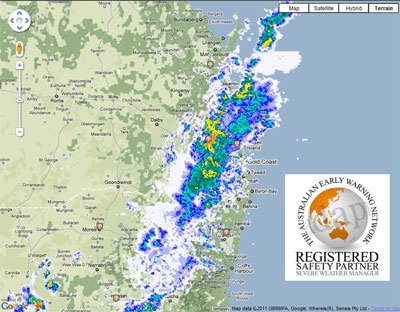
There is also The Australian Early Warning Network that republishes Bureau of Meteorology information and sends emergency alerts to mobile phones, home phones, pagers and via SMS or e-mail. It is maintained by a private company.


Lucky for Australia, the disasters are few and far between. But this is exactly what makes proactive investment in natural hazards monitoring and disaster response systems, whether government sponsored or community lead, so difficult. Interest in those systems diminishes as quickly as the tragedy disappears from news headlines. It is so hard to keep politicians and community engaged and supportive for the initiatives when there is no threat present. So, in the end, it is always up to a bunch of committed individuals who work on solutions proactively, and despite all the odds, in anticipation that their effort one day may save a life. Sad reality… So, paraphrasing JF Kennedy: “…ask not what your country can do for you – ask what you can do for your country…” to limit the outcome of natural disasters in the future!

Announcing the ArcGIS Editor for OpenStreetMap

For a while, ArcGIS users have been able to use the OpenStreetMap (OSM) content as a basemap in ArcGIS Desktop or in web applications thanks to a republishing of this content through ArcGIS Online. After the earthquakes, we have received many requests from users of ArcGIS who want to contribute to OSM, but who prefer to use the editing capabilities of ArcGIS Desktop.

For users of ArcGIS 10 this is now possible using the new free add-on ArcGIS Editor for OpenStreetMap.

The ArcGIS Editor for OpenStreetMap is designed to help ArcGIS desktop users to become an active member in the growing community of users building an open and freely available database of geographic data.

The provided tools allow the user to download data from the OSM servers and store it locally in a geodatabase. The user can then use the advanced editing environment of ArcGIS Desktop 10 to create, to modify, and to delete data. Once the edits are complete, the edit changes can be posted back to the OSM server and become available to all OSM users.

The interaction with the OSM server is accomplished using as set of geoprocessing tools to download, to manage, and to upload data.

A total of six tools support the a disconnected editing like workflow: download data from OSM, edit locally, and upload the result back to OSM.

OSM has a very flexible data model, to support some consistency in created feature types. However for more focused data capture activities, such as those that occurred after the Haiti and Chile earthquakes, a more focused data model approach is suggested. To use the new ArcGIS 10 template feature, we have mapped the common tags used in OSM to attributes and feature types, created templates for these, and implemented suggested symbols.

Editing is straightforward. After downloading your work area from OSM, you use the normal ArcGIS Desktop editing features. There are some things to keep in mind in this first release:

  • Only simple and single part geometries are supported.
  • You cannot create features with more than 5000 nodes. The OpenStreetMap server has a limit of accepting geometries with up to 2000 nodes.
  • Deleting a point, line, or polygon can have an effect of changing the relation in which the feature participates.
  • Editing of OSM relations or super-relations directly is not supported in this first release.
  • Polyons generated from data downloaded from OSM may be corrupt. To be safe: run the repair geometry tool before starting to edit.

As with any multi-user editing environment, you may run into a situation where multiple users edit the same area. This results in conflicts when trying to upload your edits to OSM. In order to mitigate the conflict the ArcGIS Editor for OpenStreetMap offers a simple Conflict Editor to help resolve the situation. Best practice is to edit a relatively small area and to save back to OSM frequently.

We are releasing this first version of the ArcGIS Editor for OpenStreetMap. and are looking for feedback. More details on the tool will become available over time, including access to the source code, and enhanced documentation.

Enjoy!