Learn about the human side of climate change with Kofi Annan

[Cross-posted on the Google.org and Official Google Blog]

Climate change is too often misunderstood to be simply an environmental issue, rather than a human issue. For our children and grandchildren, climate change is an issue of public health, economics, global security and social equity. This human side of climate change is explained in a new Google Earth tour narrated by former U.N. Secretary General Kofi Annan. Within these stories, you’ll find data and tools to explore this topic in more depth, and meet some of the people who are actively working on managing the risks of climate variability and change. We encourage you to take the tour to learn more about these human issues and the inspiring work of groups like the Alliance for a Green Revolution in Africa (AGRA) that are helping farmers cope with climate change. We hope this video will serve as a useful tool as educators help students around the world understand the complexity of this issue.

This is the latest in our series of climate change tours that we’re releasing leading up to the global U.N. Framework Convention on Climate Change (COP16) talks in Cancun, Mexico this week.

As part of the Google Earth for Educators Community, we’ve also created a special Climate Change Educators Resources page that teachers can use in their classrooms. Here, teachers can find the tools they need to create lesson plans about climate change, including all the individual Google Earth KML layers available for download. Teachers and students can overlay multiple data layers that help illustrate climate change, and discuss and analyze them as part of K-12 and higher education curriculum. We’re also looking for lessons plans for any school grade that use this narrated tour or these Google Earth KML layers, so if you’re a teacher or instructor, please submit your lesson plan for review now.


Visit google.com/landing/cop16/climatetours.html or the Climate Change Educators Resources page to learn more about climate change today.

Plant trees for change with Nobel Prize winner Wangari Maathai

(Cross-posted on the Official Google Blog)
Occasionally, we invite distinguished guests to contribute to our blogs and we’re very happy to have Wangari Maathai share her perspective here. In collaboration with Wangari Maathai’s Green Belt Movement and several other partners, the Google Earth Outreach team has created several narrated tours on the topic of climate change in preparation for the UNFCCC’s COP16 Climate Summit 2010 in Cancun, Mexico. Fly underwater to learn about the effects of ocean acidification on sea life with Oceana. Zoom around Mexican mangroves in 3D and learn about the importance of this biodiverse habitat… and what must be done to protect it for future generations. Visit google.com/landing/cop16/climatetours.html to experience these tours. -Ed.

Ask most people what trees mean to them and the first thing that comes to mind is the tree outside their bedroom window or the forest where they played as a child. Trees do occupy a powerful place in our emotions, but the most powerful argument to protect our world’s trees is not based on sentiment. There is a vital interdependency between communities and the trees they rely on for survival. Trees are our watersheds, protectors of the natural environment, and sources of food. Remove the trees from the equation and the community feels the impact.

I came to this realization in the 1970s in Kenya. I was talking to women in my community about their problems: hunger, access to water, poverty, wood fuel. I saw a link between their needs and the condition of the land and thought, “Why not plant trees to address these issues?” Trees hold the soil to the ground so that we can grow food in it, they protect watersheds and facilitate harvesting of rain water, fruits trees supplement food and trees give us domestic energy and wood with which to build our shelters. So while still working at the University of Nairobi, I established a tree nursery in my backyard, planted seven trees at a public park and founded the Green Belt Movement. The organization works to empower communities, to build their capacity to restore Africa’s forests and put an end to the problems that deforestation and other forms of environmental degradation cause. As a result of this idea, more than 40 million trees have been planted to restore the environment and improve the lives of the people who are linked to the land.

When we were offered a unique opportunity to partner with the Google Earth Outreach team on a project using new Google Earth technology to visualize trees in 3D, we were thrilled. For accuracy and integrity we worked very closely with Google, advising them on the modeling of unique African trees like the broad-leaved Croton, the Nile tulip tree and the East African Cordia. These tree models illustrate the biodiversity in our tree planting sites, especially in the forests, and how we carefully select trees that are indigenous and sustainable to the natural surroundings.

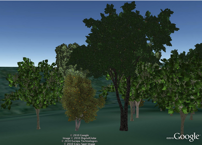
Broad-leaved Croton, the Nile tulip tree and the East African Cordia (from left to right)


We then used data from real planting locations to “plant” the tree models in Google Earth and create 3D visualizations. Now, for the first time in Google Earth, people from all over the world will be able to virtually visit these planting sites, explore the 3D trees and connect with the work that we are doing.

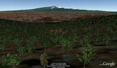
Green Belt Movement planting site in 3D on Google Earth


Tree planting is a simple activity with tangible results, and anyone can participate. It helps people come together to address common problems and work collectively towards community improvement and sustainability. I hope that seeing our beautiful tree planting sites in 3D on Google Earth will be a source of inspiration for people to engage, plant trees and organize planting activities in their own communities. Taking charge of our lives and the environment around us can help ensure a lasting legacy and healthy future for our children.

Learn more about the Green Belt Movement and support our work at http://www.greenbeltmovement.org.

US Navy Flight Week in Google Earth

Back in October, Chris Yonge of Studio Cruz and Christiaan Adams created a very cool Google Earth Tour for the San Francisco Fleet Week. The tour includes a voice overlay, images, video and more, all in one nice package.

To view the tour, you can download this KMZ file or simply watch the YouTube video below:

Because of the complexity of the tour, Chris and Chritiaan wrote up the following information on how they came up with the idea for the Tour, as well as how they were able to put it together technically. Hopefully this information is helpful if you plan to build a similar Tour for a project of your own.

This project emerged from a desire to help Fleet Week 2010 showcase its mission using a 3D animated tour in Google Earth.  Studio Cruz was recommended by the Google Earth team, and was chosen as the developer, after having produced other successful Google Earth tours, including one for Potter Drilling of Redwood City, CA in 2009, which was showcased at the Copenhagen Climate Change Conference.  Studio Cruz worked with the Fleet Week organizers to create the seven minute tour in advance of the Navy and Marines’ Fleet Week celebration in early October 2010.  The timescale was tight – only five weeks – but since no complex coding was involved it was judged possible.

The tour had three goals: to introduce the concept of Fleet Week to the public, to explain the serious purpose behind the public events (liaison between Navy and civilian disaster relief specialists), and to provide a brief history of the US Navy’s disaster relief work in the SF area and around the world. The script directed that the tour be graphics intensive, including four YouTube videos, interactive balloons, screen overlay animation, a live link to an existing online KMZ history of Bay Area earthquakes on a USGS site, and precisely synchronized professional narration.

Studio Cruz began work on the tour in early September. The YouTube videos were downloaded as Flash videos using RealPlayer, trimmed to the relevant sections using Moyea FLV Editor, then uploaded as new videos ready for embedding into the relevant parts of the tour. The script was split into 45 sections of between one and three sentences, and placeholder MP3s were created in the studio. These were later replaced by the professional narration. Photographs provided by the Navy were cropped and resaved as JPGs, and screen/ground overlays were built in Photoshop and saved out as 24-bit PNG files.

Building the tour took slightly over a week, with coding and graphics being made by Chris Yonge, principal of Studio Cruz. Since Google intended the tour to be revised and reused for future Fleet Weeks the KML code was extensively commented, down to the words spoken in each piece of narration. After the build stage, the placeholder narration audio files were replaced with the final professional versions. This required minor timing adjustments throughout the tour, but once that was done the tour was delivered and posted.

Google also wanted a video version of the tour for visitors to the Fleet Week site who did not have Google Earth. For clarity and quality this was done using the screen capture program Camtasia; the resulting AVI files were assembled in AfterEffects and adjusted. However, some parts of the tour did not capture well: in particular the slowdown caused by Camtasia operating in the background meant there was an unacceptable pause before the YouTube videos started. The decision was made, a few days before the deadline, to rewrite the tour specifically for the video capture. Animation, video, narration, and interactive balloons were removed from the KML file. The reduced tour was run and captured as a video in Camtasia, and the resulting files imported into AfterEffects. The removed items were then replaced as individual layers, resulting in much higher quality. The raw animation was around 14 Gb, which was compressed to 700 Mb for uploading to YouTube. It can be seen at http://www.youtube.com/watch?v=Le5GqmV6ASg.

Both the tour and video were completed on time and to budget. The video alone had over nine thousand views the first weekend. Studio Cruz can be found at www.studiocruz.com.