Street View is digitalizing Japan’s disaster zones

After the March 11 earthquake and tsunami devastated the coastal communities of Eastern Japan, we at Google tried to find ways to use our technologies in support of relief activities. This started immediately after the quake with our Person Finder to help locate displaced individuals, and more recently we’ve started projects to spur economic recovery in the affected areas, such as the “YouTube Business Support Channel,” which enables local businesses to promote their products and establishments to a nationwide audience.

We also believe that the Street View feature in Google Maps can be a useful tool to offer street-level imagery of the recovery efforts. Many photographers felt the disaster couldn’t be captured in just one photo or with a single camera, but immersive, 360-degree panoramic images can help people — especially those abroad — better understand the scope of the destruction.


On July 8, we announced that we’ll be driving our Street View cars across major cities (such as Sendai) and coastal cities of the Tohoku region to not only help communicate the current state of the disaster-affected areas, but also to digitally archive the area’s landscapes for future generations. This imagery will help people in Japan and across the world remember and observe the tragedy of March 11, 2011.

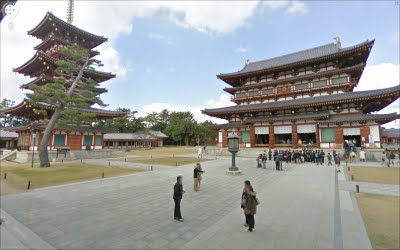
In addition to preserving history through Street View, the team in Japan has been busy publishing 360-degree imagery of more than 100 famous sites across Japan through our Street View Partner Program. The places that have partnered with us to share views of their locations on Google Maps include UNESCO world heritage sites Yakushi-ji temple, Toshodai-ji temple, and Kasuga-Taisha shrine in the ancient capital city of Nara. We’re also continuing the Business Photos project in Japan and are working with hundreds of businesses to photograph their interiors, get those images online, and show both local customers and visitors that they are open for business.

Yakushi-ji Temple in Nara, Japan
If you’re interested in directly supporting the ongoing relief effort in Japan, you can find more information regarding the disaster and resources for those in need at our Crisis Response page in English and Japanese.

The RHoK community

Two years ago representatives from Google, Microsoft, Yahoo!, Hewlett-Packard, NASA and the World Bank came together to form the Random Hacks of Kindness (RHoK) program. The idea was simple: technology can and should be used for good. RHoK brings together subject matter experts, volunteer software developers and designers to create open source and technology agnostic software solutions that address challenges facing humanity. On June 4-5, 2011 we’ll hold the third Random Hacks of Kindness global event at five U.S. locations and 13 international sites, giving local developer communities the opportunity to collaborate on problems in person.

The RHoK community has already developed some applications focused on crisis response such as I’mOK, a mobile messaging application for disaster response that was used on the ground in Haiti and Chile; and CHASM, a visual tool to map landslide risk currently being piloted by the World Bank in landslide affected areas in the Caribbean. Person Finder, a tool created by Google’s crisis response team to help people find friends and loved ones after a natural disaster, was also refined at RHoK events and effectively deployed in Haiti, Chile and Japan.


We’re inviting all developers, designers and anyone else who wants to help “hack for humanity,” to attend one of the local events on June 4-5. There, you’ll meet other open source developers, work with experts in disaster and climate issues and contribute code to exciting projects that make a difference. If you’re in Northern California, come join us at the Silicon Valley RHoK event at Google headquarters.

And if you’re part of an organization that works in the fields of crisis response or climate change, you can submit a problem definition online, so that developers and volunteers can work on developing technology to address the challenge.

Visit http://www.rhok.org/ for more information and to sign up for your local event, and get set to put your hacking skills to good use.

Google Maps and Earth – Post-tornado mapping

This past week, several devastating tornadoes struck across a wide swathe of the southern United States. Our Crisis Response team is activating to provide data and imagery we hope will be useful to first responders and the general public.

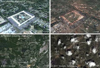
In cooperation with our satellite partner GeoEye, we have imagery of the aftermath of several tornadoes, including in Tuscaloosa, Alabama as shown below. We have created several before-and-after comparisons in a Picasa album.

Left: Google imagery from late 2010. Right: GeoEye imagery from Thursday, April 28.
Top: Charleston Square Apartments, Tuscaloosa, Alabama. Bottom: Towns of Pleasant Grove, Concord, and Hueytown, Jefferson County, Alabama. Click to see enlarged.

This imagery, as well as data sets such as Red Cross shelter locations and tornado touchdown reports, are available in this collection on Google Maps. We will continue to add imagery and data as it comes available.

Our heart goes out to everyone affected by this tragic event.

Update: You can now access the satellite imagery directly in Google Earth. Make sure the Places layer is enabled, then go to Alabama. Click the image of a tornado to find links to load the images.