In times of disaster and humanitarian needs, relief activities are sometimes carried out in chaotic and dynamic conditions in which multiple groups need to interact. First responders need to quickly build an on-the-ground picture of where people are, what condition they are in, what their needs are, what services are still available, and what resources have survived. This helps relief and humanitarian responders as well as local planners to plot and obtain a big picture of the impact of the disaster. They are then able to target their efforts and mobilize their resources of equipment, personnel, and supplies. Unfortunately, despite many technical and institutional advances, basic data is often not readily available on the onset of a disaster.
As Einar Bjorgo, UNITAR/UNOSAT’s head of Rapid Mapping, Applications and User Relations, has noted, Google Map Maker addresses a significant part of this data gap by capturing community knowledge — verified through community moderation — and making it available in near real-time. UNITAR/UNOSAT is the only operational UN program fully focused on providing satellite imagery and mapping products to the humanitarian community, including its United Nations’ sister agencies and governments — and it now does so largely with Google’s Map Maker data.
Today, after years of successful collaboration, UNITAR/UNOSAT (the operational satellite applications program of UNITAR) and Google have strengthened their joint efforts by signing an agreement that will give the crisis response and humanitarian community increased access to Google Map Maker source data for use in their disaster response and humanitarian activities, in more than 150 countries around the world.*
Under this agreement UNITAR/UNOSAT will act as a conduit within the United Nations family and its Member States to make Google Map Maker data more widely and easily available to aid organizations in the event of major disasters and for humanitarian efforts. In addition, government and United Nations agencies will be able to contact UNOSAT/UNITAR (email unosat@unitar.org) for consideration as potential licensees of the Google Map Maker data, for their disaster response, humanitarian and development projects. This agreement builds on dozens of previous joint mapping efforts between UNITAR/UNOSAT and Google, such as the ones that were coordinated for Pakistan, Sudan, and West Africa.
UNOSAT Manager Francesco Pisano shared his thoughts, noting that “Google Map Maker gives us access to baseline data over areas where detailed information is usually unavailable. Now roads, bridges, buildings, and other services, with local and official names, can be mapped and damages tracked in near real-time. This new ability to integrate Google Map Maker data more widely into our satellite analysis will have a monumental impact on UNOSAT’s ongoing efforts to make geographic information a key part of providing information for modern humanitarian relief. This agreement will also bring key benefits to the broader disaster and humanitarian community by making Google Map Maker data more widely and easily available.”
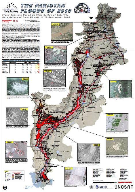
UNOSAT map of the flood-affected areas in Pakistan. It uses Map Maker data as its primary source of Road and Place names data.
With this new agreement with UNITAR/UNOSAT, we are expanding our ability to share useful map data that the Map Maker community contributes with the world, for increased benefit to people all over in preventing and recovering from man-made and natural hardships. We’re thrilled to deepen our relationship with the United Nations, and their partners. We welcome you to join the Map Your World Community, and start mapping to contribute to this effort and increase the quality of maps data. If you are one of our long-term mappers, thank you for your efforts that inspire us to keep finding ways to together make a positive difference to the world. Keep mapping!
Posted by France Lamy, Program Manager, Google.org
*Countries for which UNITAR/UNOSAT will have access to Google Map Maker data: Afghanistan, Albania, Algeria, American Samoa, Angola, Anguilla, Antigua and Barbuda, Argentina, Armenia, Aruba, Bahamas, Bahrain, Bangladesh, Barbados, Belarus, Belize, Benin, Bermuda, Bolivia, Botswana, Bouvet Island, British Indian Ocean Territory, British Virgin Islands, Brunei,Burkina Faso, Burundi,Cambodia, Cameroon, Cape Verde,Cayman Islands, Central African Republic, Chad, Chile, Christmas Island, Cocos (Keeling) Islands, Colombia, Comoros, Congo, Cook Islands, Costa Rica, Cote d’Ivoire, Cuba, Democratic Republic of the Congo, Djibouti, Dominica, Dominican Republic, Ecuador, El Salvador, Equatorial, Guinea, Eritrea, Ethiopia, Faroe Islands, Fiji, French Polynesia, French Southern and Antarctic Lands, Gabon, Gambia, Ghana, Greenland, Grenada, Guadeloupe, Guatemala, Guinea, Guinea-Bissau, Haiti, Honduras, Iceland, Iraq, Jamaica, Jordan, Kazakhstan, Kiribati, Kuwait, Kyrgyzstan, Laos, Liberia, Libya, Madagascar, Malawi, Malaysia, Maldives, Mali, Malta, Marshall Islands, Mauritania, Mauritius, Micronesia, Mongolia, Montenegro, Montserrat, Morocco, Mozambique, Myanmar (Burma), Namibia, Nauru, Nepal, Netherlands Antilles, New Caledonia, Nicaragua, Niger, Nigeria, Niue, Norfolk Island, North Korea, Northern Mariana Islands, Oman, Pakistan, Palau, Panama, Papua New Guinea, Paraguay, Peru, Philippines, Pitcairn Islands, Qatar, Romania, Rwanda, Saint Helena, Saint Kitts and Nevis, Saint Lucia, Saint Pierre and Miquelon, Saint Vincent and the Grenadines, Samoa, Sao Tome and Principe, Senegal, Seychelles, Sierra Leone, Solomon Islands, Somalia, Sri Lanka, Sudan, Suriname, Svalbard and Jan Mayen, Swaziland, Tajikistan, Tanzania, Timor-Leste, Togo, Tokelau, Tonga, Trinidad and Tobago, Tunisia, Turkmenistan, Turks and Caicos Islands, Tuvalu, Uganda, Uruguay, Uzbekistan, Vanuatu, Venezuela, Vietnam, Wallis and Futuna, Western Sahara, Yemen, Zambia, Zimbabwe