Solar Permit AppEngine Examples

It was a milestone that took over 50 years, and at last solar panel manufacturers can produce their modules for less than $1/Watt. Now, the renewable energy community is faced with the dilemma that the permitting and interconnection costs, i.e. the paperwork, is a significant fraction of the cost of a rooftop installation. To deploy gigaWatts of solar energy in the United States these costs need to drop. In response, the Department of Energy has made permitting part of its Sun Shot Initiative and SolarTech has launched its Solar Permitting Challenge. And now Google is pleased to announce Solar Permitting Code Examples to make it faster for software developers to be productive using AppEngine.
A small team of Googlers (Alex Martelli, Arjun Satyapal, Clay Murphy, Luke Stone, Ross Koningstein and Dave Fork) pooled their 20% time to help out. We tried to make the task of building a web based permitting application easier by providing examples of essential tasks in AppEngine including login, creating new permit requests, uploading files, and gathering statistics. Two different versions, one in Python and one in Java, were created.
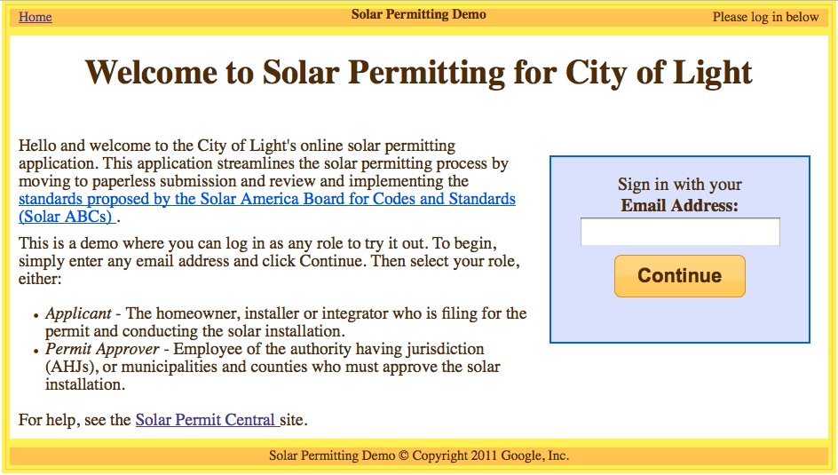
We were inspired to create this code example by the work that SolarTech has done to promote faster permitting through its Solar Permitting Challenge, and by the Solar ABCs efforts to produce a simple, uniform process for solar permitting. The user login screen for the Python code example appears below.
Navigant consulting estimates that there are 700 gigaWatts of solar power generation resource on rooftops in the United States. Overall, we believe that efforts to streamline the workflow connected with rooftop solar installations could reduce the costs of installations by 50 cents/Watt. Please help us help the industry make this a reality.

Video Demonstration: Illinois Public Health Map

We’re very happy to be able to show-off our collaboration with the Illinois Department of Public Health and IPRO. This map makes information about the quality of health in communities available to the public, highlighting socioeconomic disparities that may exist. When combined with our indiemapper platform as well as linked graphs and charts, the clinical data in the map can be used to examine the health needs of a community, county or region for better policy and planning.

Above is a quick demonstration video showing the basic functionality. After watching the video, check-out the map itself.

Summer Sketch Workshop in Toruń, Poland

This past summer, Supermodeler Arkadiusz Pawlowski (a.k.a. Arek, a.k.a. aroo) decided to hold a SketchUp workshop for students at the Nicolas Copernicus University of Toruń. He partnered with fellow Toruń alumni Radoslaw Golba to teach the course. I asked him a few questions about the experience:

Arek alongside the workshop participants

Why did you decide to hold a workshop?

It was like an impulse I had on my way back from the 2010 Google Mapper and Modeler Summit held in Zurich. I came to the conclusion that it would be a good thing to organize classes for students to teach them what I knew about geo-modeling with SketchUp.

So the purpose of the workshop was to teach students how to geo-model?

Yes, but I also wanted to increase the students’ knowledge of modeling tools and have them practice visualizing objects in a digital 3D form. I encouraged them to work independently and to further develop the skills that they could use beyond geo-modeling.

Workshop in session

What was the schedule like for the workshop?

Since most of the students had never used SketchUp before, the first day of the workshop was used to let them familiarize themselves with the program. On the second day, students went out to collect photographs of selected buildings, and then later edited the images to make textures for the model. The third day of the workshop was for actually modeling the buildings in SketchUp and then texturing them with the previous day’s photos. All of the complete models are in a collection on the 3D Warehouse.

The workshop was also supported by the Department of Cartography, Remote Sensing and Geographical Information Systems of University of Toruń, who handed out certificates to participants at the end of the workshop… and Google provided t-shirts. :)

Workshop participants sporting awesome Google shirts

See more photos of Arek’s workshop, and download the placemarks of all the buildings created in the workshop, then view the models in Google Earth.