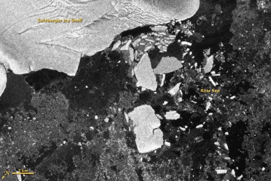
When the earthquake (and subsequent tsunami) struck Japan earlier this year, we provided as much data as possible about the disaster. What many people didn’t realize was that the tsunami continued to travel across the ocean, eventually striking Antarctica with a great deal of force. This caused some flexing and breaking of the Sulzberger Ice Shelf, which resulted in two large icebergs being released, reminicient of the chunk of the Wilkins Ice Shelf that broke off a few years ago. Combined, the icebergs cover an area of 125 square kilometers, or more than twice the size of New York’s Manhattan Island!
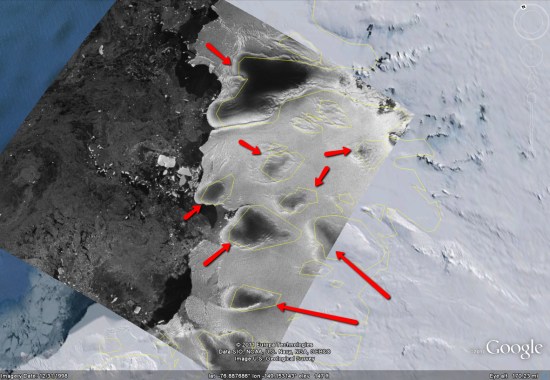
If you turn on the “Borders and Labels” layer in Google Earth, you’ll see the yellow outlines match up quite well with the dark patches in the overlay, as seen here:
People are usually amazed how quick and easy it is to put a place in Google Earth. Here you can see 10 easy steps used to learn about a place I read about today at GoogleSightseeing. They were writing about the extensive canal system across Germany – something I was not really familiar with. I was fascinated by their fourth entry which described the Magdeburg Water Bridge, which they said is the longest aqueduct in Europe. Watch the short video below to see 10 steps I took to learn more about this place in GE:
You can watch the steps I took in the video above.
First I found something interesting through a blog post at GoogleSightseeing.com. Alex posted some details in his post, but I find it more interesting to discover with Google Earth.
So, I followed the link to view the location in Google Earth.
The first thing I do in Google Earth is turn on the “Places“, “Photos” and “More” layers in Google Earth.
The blue icons represent photos taken by many people around the world found at Panoramio (millions of photos are mapped into Google Earth).
I quickly found a ground level photo which showed the bridge (there were even aerial photos in this case).
Found a nice photo from the bridge itself as well.
The white icon from “More” layer represents a Wikipedia story. Here you get a good description of the Magdeburg Water Bridge and a link to the full article with even more details.
You can use the Google Earth navigation gadget in the upper right to turn and tilt your view to get other perspectives of any site.
Zoom out a bit and turn on the Roads layer to get a handy map of the area.
Zoom out even more and turn on the Borders and Labels layer (you might want to turn off the other layers at this point). This gives you a broader perspective. (Tip: you can also turn on the “View->Overview Map” – or hit “CTRL-M” to get a fast broad perspective map).
These are just some really basic steps I often take when trying to learn about a place. Another useful layer is the Google Earth Community layer, found inside of the “Gallery” layer. Although, for some popular places you may find dozens of placemarks by people who have posted about their favorite places – almost too much information. There are many other collections and tools (written about on this blog) for learning all kinds of things like weather, conditions of the environment, real estate prices, history, etc.
The world is a big place, and these techniques won’t work for every single place on the planet. But, if you try them out, you will probably be surprised just how much you can learn (and how many hours you can spend learning about places you’ve always wanted to visit).
Nearly six years ago, the “National Geographic Magazine” layer was added to Google Earth. While we haven’t discussed it much lately, it remains one of the great gems inside of Google Earth. You can find it under the “Gallery” layer in Google Earth.
One of the best parts of that layer is the “Africa Megaflyover” photos that were captured by Michael Fay. Michael took over 92,000 photos while flying across parts of Africa, and hundreds of them are visible in Google Earth. The quality of the images is stunning, as shown here.
User “Reggie98” in the Google Earth Community built a great collection of placemarks to highlight the African animals captured in these photos, and organized them by animal type. The original post is from 2005, but still does a great job of showing off the animals.
There is a lot of great stuff to explore in the National Geographic layer, so go check it out. Also, with nearly 1.3 million subscribers, the Google Earth Community continues to be a great way to meet other Google Earth users and find answers to your questions. If you haven’t been out there in a while, we certainly suggest you check it out.