A cool Google Map mashup of two French guys journey
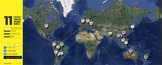
Phillipe and Josue are two French guys who have taken a year’s sabbatical and decided to travel around the world. To help the world follow their journey they have created a cool Google Map of their journey that they call, 11 (onze) Mois sans toi(t)
The map shows all the stops that the pair have made on their journey so far. The information for each window includes Tweets, Facebook updates and photographs taken at that location. The map also includes the option for users of the map to add places of interest around the world that they think the guys should visit on their journey.
Your Story with Google Maps
I’m sure everyone has a story to tell – and you can tell yours with this Google Map.
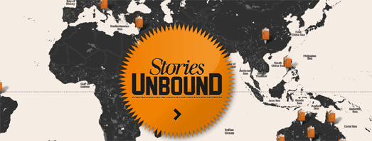
Stories Unbound was created for the Melbourne Writers Festival. It is a social media platform (website and iPhone app), that lets users write and geotag stories wherever and whenever the mood strikes.
You can read submitted stories by selecting a marker on the map. It is also possible to select a story from the slide-out sidebar, where you can also submit your own story by selecting a location on the map.
The Google Maps interface for Stories Unbound uses Google Map Styles to create a map which is in keeping with the Melbourne Writers Festival brand. The clean look of the map, with most of the map labels removed, also creates a clean interface, which encourages the user to explore stories by location.
Google Maps for Flash
Google has announced that the Google Maps API for Flash has been deprecated. This means that no new features will be developed, and only critical bugs, regressions, and security issues will be fixed in the API.
Google says that “use of the Maps API for Flash remains a small percentage of overall Maps API traffic, with only a limited number of applications taking advantage of features unique to the Maps API for Flash.”
Perhaps the one unique feature available in the The Maps API for Flash and not available in the JavaScript API is the 3DMap object. The 3DMap object allows Flash map developers to create oblique map views and rotate Google Maps. It does seems to be a unique feature that was used very little.
The only map that I can remember that used this feature was a really cool application that let you create your own weather map. However the application no longer seems to exist. Luckily I did manage to video the application when it was released, so you can view the 3DMap object put to good use in the video below.
Sadly for map developers the Yahoo Maps API is also on the way out. From September 13th Yahoo will no longer support:
- ActionScript 2 & 3 (Flash APIs)
- AJAX Maps 3.6, 3.7, 3.8
- REST API (Map Image API)
- Simple API – (No coding)
- GeoRSS – Version 2
Google Geo Developers Blog
Ghostly International Live Map
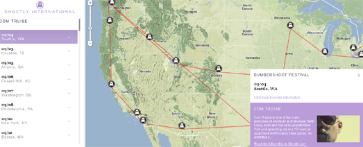
The record label and art company Ghostly International has created a Ghostly International – Live Map so that you can follow all their currently performing artists.
The Live Map lets you select an individual artist from the map sidebar and view all their upcoming events on a Google Map. When you select an artist from the sidebar an information window opens with a brief bio of the selected artist.
45° Imagery for 24 cities
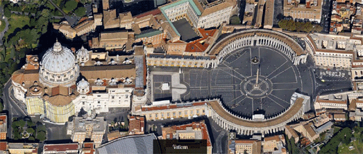
Google Maps has had another big update of 45° (bird’s eye view) imagery. 24 new cities, including Lausanne, Switzerland and Girona, Spain, now have oblique view imagery in Google Maps.
To mark the occasion I have put together this Aerial View Slideshow, to highlight some of the best of the 45° imagery now available in Google Maps.
Google LatLong
Local Events with Google Maps
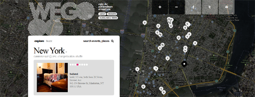
WeGooo is a Google Maps based application for finding nearby events.
Once you enter a location WeGooo displays a Google Map of the location with a time-line of nearby events. You can browse the events in chronological order from the time-line or find events by location by selecting a venue’s marker on the map.
It is possible to change your location on the map by dragging the ‘That’s me’ marker to a new position. If you select an event from the time-line the map will also display a route from your current location to the selected venue.
Fun with Google Maps
The Art of Running – A Tribute to Steve Jobs
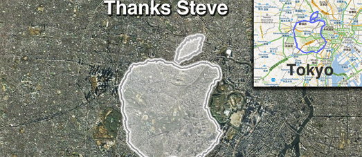
Apparently someone called Steve Jobs got a new job this week, news of which seemed to send the world reeling. The news certainly seemed to have a strange effect on Joseph Tame.
Using his iPhone and RunKeeper Joseph set out to create a giant geoglyph of the Apple logo by running around Tokyo.
Don’t Pass Gas
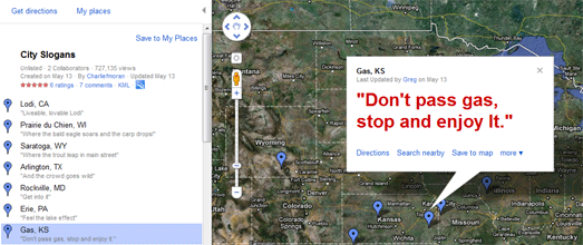
City Slogans is a Google MyMap of witty slogans that towns in the U.S. have invented to try to entice you to visit.
Amongst the gems on offer is Hooker, OK with “It’s a location, not a vocation” and Algona, IA with “Home of the World’s Largest Cheeto”.
So Long and Thanks for all the Fish

The Google Maps Street View trike has taken a visit to Seaworld Orlando. On his visit he took a number of photographs including this shot of the performing dolphins.