Google Earth 6.1 has just been released, and it comes with a handful of very nice features. You can download the new version here.
Changes to “Places”
With our ever-growing collections of saved Places in Google Earth, they’ve added a few tools to help us keep them organized. If you have a folder full of places, you can now click on that folder and sort them all from A-Z. In addition, there is now a small search bow at the bottom of your “places” window that allows you to search within your saved places to find items.
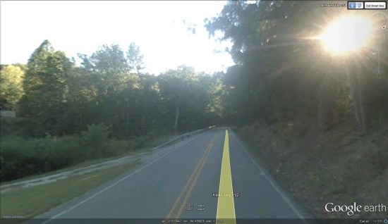
Changes to Street View
Late last year, Google added some big improvements to the Street View mode in Google Earth 6. They’ve now refined it a bit further by allowing you to single click to move to a new location (instead of requiring a double-click) and they’ve improved the zoom feature. Now you’re able to use the slider control on the right side of the screen to zoom in and out with much greater control. Street View in Google Earth also has a slightly wider field of view, similar to that found in Google Maps.
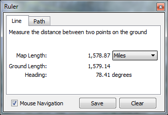
New lengths in ruler
We just showed you some great ways to use the Google Earth ruler a few weeks ago, and it had a minor change with this update. When using the “line” tool, instead of just telling you the length of the line, it will show you the “map length” along with the “ground length” of the line, which can vary slightly.
New fonts for street/place labels
It’s hard to tell exactly what they’ve done, but it appears the fonts have been reduced in thickness (un-bolded, sort of), but also increased slightly in size. In any case, they’re a bit easier to read.
Minor tweaks in the sidebar
Along with the changes to the “Places” section, they’ve revamped some of icons over there, and turned the (+) folder expansions into soft arrows, to make it look a bit less harsh.
New settings in “Tools –> Options”
You can now set the “Units of Measurement” to use your system default (rather than specifically choosing feet vs. meters)
“View –> Reset” menu option
This is still accomplished more easily with the keyboard, but you now have some options to reset your view with the menu. If you’d prefer to reset with the keyboard, you can press “n” to face north, “u” to reset to a top-down view, or “r” to reset both.
“Help –> Upgrade to Google Earth Pro…” menu option
A very minor addition; another bit of encouragement to upgrade to Google Earth Pro. Clicking this simply loads an informational page on what you’ll get in Google Earth Pro.
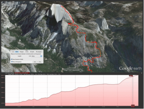
Updates in Google Earth Pro
Speaking of GE Pro, 6.1 has brought some nice updates to that product on top of the updates listed above including enhancements to the printing layout, movie maker and better support for proxies and SSL certificates. They also tied the elevation profile into the ruler tool, saving a step when working with paths, as shown in the screenshot here. More details about the Google Earth Pro updates can be found on the Google Enterprise Blog.
All in all, it’s a solid update. Nothing groundbreaking, but lots of little enhancements to make the Google Earth experience better for every user.
Google Lat Long Blog