Facebook Stories using Bing Maps

Facebook Stories using Bing Maps

Find Facebook Stories by location using Bing Maps


Facebook is all about your individual and collective experiences of you and your friends. It’s filled with hundreds of millions of stories. Which ones inspire you? What’s your Facebook story?

Facebook has launched a new application highlighting shared stories about people who have leveraged Facebook to reconnect.
The app “Facebook Stories” uses stories that have been authored by users who’ve found family, friends and flames on Facebook after having been long disconnected and used the social network to find one another amongst the 500 million Facebook users.

Of the stories that have been published, Facebook is providing you with location context via Bing Maps. For those users that are reading the stories a map provides that visual representation to stories location.

The application lets you scroll through stories on Bing Maps (by location), as well as by dozens of themes

Google Places Quality Guideline Minor Update

With the ending of Google’s real estate listing service in Maps, it was necessary for Google to update the Google Places Quality Guidelines to reflect the fact that the service was no longer available as a listing option:
Previous Guidelines New Quality Guidelines
Ineligible Business Models: Only businesses that make in-person contact with customers qualify for a Google Places listing. Ineligible Business Models: Only businesses that make in-person contact with customers qualify for a Google Places listing.
Rental properties, such as vacation homes or vacant apartments, are not eligible for a listing on Google Places. Create a listing for the central office that processes the rentals, rather than the individual rental properties. If you’d like, you can then add your real estate properties to Google Maps so that they are available on our Real Estate layer. Rental or for sale properties, such as vacation homes or vacant apartments, are not eligible for a listing on Google Places. Create a listing for the central office that processes the sales or leasing offices, rather than the individual rental properties.

Related posts:

  1. Google Places Updates Quality Guidelines
  2. Google Places Quality Guidelines Comparison
  3. Google Places Quality Guideline Update

Predict how much solar power your house could generate

The fact that the rise of alternative energy and the rise of Google Earth are happening at the same time has let to a lot of great Google Earth visualizations of potential alternative energy use, particular with solar power. We’ve seen a 3D rendering of the solar panels at the Googleplex and the US Solar Jobs Map, which shows the potential for hundreds of thousands of new solar-related jobs in the next few years.

We also showed you the Berlin Solar Atlas Project, which allows you to view the “solar potential” for over 14,000 roofs in the city. Today’s story is very similar, but on a much wider (though less detailed) scale.

Coming from the University of California – San Diego is the “California Solar Irradiance Map“, which shows the entire state of California and the amount of energy a horizontally oriented solar panel could expect to receive over the course of a year.

ca-solar.jpg

Beyond the overview map that you see above, you can zoom down and get specific data for thousands of individual points on the map, the most important of which is likely the “monthly mean irradiation” that shows how much energy could be generated at different times of the year.

ca-solar-detail.jpg

To try it for yourself, download their KMZ file 
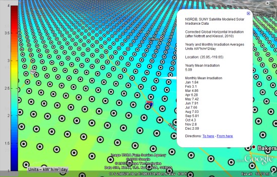
and give it a shot. To see the individual placemarks, be sure to turn on the “Placemark Data” folder inside of the KMZ.