Google earth: Imagery Update (and Kansas Basketball)

We’re in the middle of college basketball Madness here in the U.S. and the best is yet to come. Tomorrow night, the Kansas Jayhawks will play the Richmond Spiders in a Sweet Sixteen match-up at the Alamodome in Texas. I’ll proudly admit that I’m a Kansas fan and hoping to see my home team make it to the Finals. But I’m not the only college hoops fan at Google. In fact, our Geo team put together a special page that shows an up-to-date schedule with schools and stadiums.

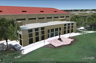
In our latest imagery push, we (coincidentally) added new imagery of Lawrence, Kansas and a new 3D model of the Allen Fieldhouse, possibly the best basketball venue on Earth. As a longtime Lawrence resident and KU alumnus, I still remember my first games in the “Phog” when I was in junior high school, watching from the upper bleachers. The Fieldhouse has aged well with the new Booth Family Hall of Athletics and the parking additions.


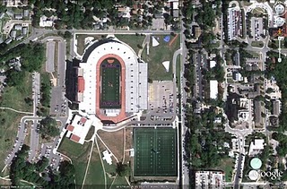
When I’m feeling like I need even more of a dose of home, it’s also great to be able to check out some of my favorite places back in Lawrence through Google Earth and Google Maps. With the new high-resolution aerial imagery, you can now see many changes including the updates to Memorial Stadium and the large practice fields.


Additional basketball-related updates include Gainesville (Florida), Tallahassee (Florida State), and Manhattan, the Little Apple (Kansas State [5]). We’ve also updated many other locations around the world that can be seen and discovered in our latest batch of published imagery including major updates in Sydney, Tokyo, Stockholm and significant parts of Ireland.

High Resolution Aerial Updates:
USA: Boca Raton, FL; West Palm Beach, FL; Port St Lucie, FL; Crystal River, FL; Ocala, FL; Gainesville, FL; Tallahassee, FL; Valdosta, GA; Savannah, GA; Jackson County, GA; Bedford County, PA; Cumberland County, PA; Manhattan, KS; Topeka, KS; Lawrence, KS
Wales: Northern Half
Scotland: Hawick
Japan: Tokyo; Kawasaki; Yokosuka
Australia: Sydney, Brisbane, Canberra

Countries/Regions receiving High Resolution Satellite Updates:
Antarctica, United States, Canada, Mexico, Cuba, Haiti, Dominican Republic, El Salvador, Panama, Bolivia, Paraguay, Brazil, Argentina, South Africa, Madagascar, Namibia, Zimbabwe, Zambia, Angola, Tanzania, Kenya, Burundi, Rwanda, Democratic Republic of the Congo, Uganda, Ethiopia, Sudan, Central Africa, Niger, Ivory Coast, Togo, Liberia, Senegal, Morocco, Algeria, Tunisia, Egypt, Israel, Jordan, Syria, Saudi Arabia, Bahrain, Qatar, United Arab Emirates, Kuwait, Yemen, Iran, Pakistan, Tajikistan, India, Bangladesh, China, Myanmar, Thailand, Taiwan, North Korea, Japan, Mongolia, Indonesia, Australia, New Zealand, Russia, Georgia, Armenia, Azerbaijan, Turkey, Greece, Bulgaria, Romania, Ukraine, Hungary, Austria, Poland, Croatia, Italy, Germany, Switzerland, France, Spain, Portugal, Ireland, Norway, Sweden, Finland, Greenland

These updates are now available in both Google Maps and Google Earth. To get a complete picture of where we updated imagery, download this KML for viewing in Google Earth.

Deep sea exploration with the joint Indonesia-USA Ocean Expedition

Come on a tour to never-before explored Indonesian waters. The INDEX-SATAL 2010 Expedition is the first-ever joint ocean research voyage by the Republic of Indonesian and the United States. To experience it yourself, watch a Google Earth YouTube video tour here or explore the area more interactively with the Google Earth plug-in on our Ocean Showcase.
The colored surface areas seen in the video represent underwater terrain data collected during the expedition. The data, highlight photos and videos have been incorporated into Google Earth so you can now explore them on your own by diving under the surface.
Much of the Coral Triangle remains unexplored, and this partnership aims to help reverse the decline of coral reefs in the area and to protect natural resources. The expedition began in the SATAL region around two island chains stretching north of Sulawesi. It was undertaken by scientists from the USA National Oceanic and Atmospheric Administration, Indonesia’s Ministry of Marine Affairs and Fisheries, and the Indonesian Agency for the Assessment and Application of Technology.
“Telepresence” was used to send data in real time to scientists who stood watch at Exploration Command Centers in Jakarta and Seattle. This same technology brought the excitement of the expedition to visitors at the Exploratorium in San Francisco as well.
Little Hercules, a remotely operated exploration vehicle, descended 6000 feet under the sea to capture images and videos of exciting sights like hydrothermal vents and creatures like the deep sea octopus seen below:
Mapping and discovery data from expeditions like this will help all organizations involved better understand ocean resources and how to protect them. More information about the still mysterious ocean will ultimately further economic and environmental initiatives such as the management of sustainable fisheries, the conservation of the marine environment and the preservation of fragile corals.
Dive deeper at Oceanexplorer.noaa.gov.
By Jenifer Austin Foulkes, Product Manager, Ocean in Google Earth and Maps

New panoramic photos in Google Earth


Viewing photos in Google Earth has long been a popular activity for avid virtual globe-trotters. It’s one of the best ways to “visit” places all over the world without paying for a plane ticket or getting jet lag. Today, the Google Earth photo viewing experience just got better with the addition of panoramic images.

People using Google Earth will find a new “Photos” layer that includes not only the existing 2D photos from the Panoramio community, but also panoramic photos from around the world contributed by users of 360cities.net. These high-resolution panoramic photos are marked in Google Earth as red square icons. When you click on one of these icons, an info bubble containing an image appears, and clicking on the image again will take you into our photo viewing mode. You can then look around in 360-degree views and experience the place as if you’re standing right at the center of it.

new “Photos” layer on Google Earth
info bubble on Google Earth

These panoramic photos are shot by average people just like you and me. To contribute your panoramic photos, visit 360cities.net. We invite all users to become part of the community and mark your photo journey in Google Earth.

Check out some of the beautiful images now available right in Google Earth.

Golden Gate Bridge on Google Earth and on 360cities.net
Gapang Beach, Pulau Weh, Indonesia on Google Earth and on 360cities.net

Lion’s Head, South Africa on Google Earth and on 360cities.net

Diving New Caledonia Amedee Island on Google Earth and on 360cities.net

Umag Asanas, Istria at sunset on Google Earth and on 360cities.net

Panthéon and Foucault pendulum, Paris on Google Earth and on 360cities.net

Posted by Wei Luo, Senior Geo Data Strategist