Building a healthier, greener Google

When it comes to greening our office buildings, we apply the same focus that we use for any of our products: put the user first. We want to create the healthiest work environments possible where Googlers can thrive and innovate. From concept through design, construction and operations, we create buildings that function like living and breathing systems by optimizing access to nature, clean air and daylight.

Since I arrived at Google in 2006, I’ve been part of a team working to create life-sustaining buildings that support the health and productivity of Googlers. We avoid materials that contain volatile organic compounds (VOCs) and other known toxins that may harm human health, so Googlers don’t have to worry about the air they’re breathing or the toxicity of the furniture, carpet or other materials in their workspaces. We also use dual stage air filtration systems to eliminate particulates and remaining VOCs, which further improves indoor air quality.

Since building materials don’t have ingredient labels, we’re pushing the industry to adopt product transparency practices that will lead to real market transformation. In North America, we purchase materials free of the Living Building Challenge Red List Materials and EPA Chemicals of Concern, and through the Pharos Project we ask our suppliers to meet strict transparency requirements.

We also strive to shrink our environmental footprint by investing in the most efficient heating, cooling and lighting systems. Throughout many of our offices, we’ve performed energy and water audits and implemented conservation measures to develop best practices that are applied to our offices worldwide. To the extent possible, we seek out renewable sources for the energy that we do use. One of the earliest projects I worked on at Google involved installing the first solar panels on campus back in 2007. They have the capacity to produce 1.6 megawatts of clean, renewable electricity for us, which supplies about 30 percent of our peak energy use on the buildings they cover.

With a little healthy competition, we’ve gotten Google’s offices around the world involved in greening our operations. Our internal Sustainable Pursuit program allows teams to earn points based on their office’s green performance—whether it’s through green cleaning programs, water efficiency or innovative waste management strategies. We use Google Apps to help us track progress toward our goals—which meet or exceed the U.S. Green Building Council’s LEED standards—and share what we’ve learned among our global facilities teams.

We’re proud of our latest LEED Platinum achievement for the interior renovation of an office building at the Googleplex. While we have other LEED Platinum buildings in our portfolio, it’s a first for our headquarters and a first for the City of Mountain View. The interior renovation was designed by Boora Architects and built by XL Construction, using healthy building materials and practices. In fact, we now have more than 4.5 million square feet of building space around the world on deck to earn LEED Certification.

via Green blog
Solar Permit AppEngine Examples

It was a milestone that took over 50 years, and at last solar panel manufacturers can produce their modules for less than $1/Watt. Now, the renewable energy community is faced with the dilemma that the permitting and interconnection costs, i.e. the paperwork, is a significant fraction of the cost of a rooftop installation. To deploy gigaWatts of solar energy in the United States these costs need to drop. In response, the Department of Energy has made permitting part of its Sun Shot Initiative and SolarTech has launched its Solar Permitting Challenge. And now Google is pleased to announce Solar Permitting Code Examples to make it faster for software developers to be productive using AppEngine.
A small team of Googlers (Alex Martelli, Arjun Satyapal, Clay Murphy, Luke Stone, Ross Koningstein and Dave Fork) pooled their 20% time to help out. We tried to make the task of building a web based permitting application easier by providing examples of essential tasks in AppEngine including login, creating new permit requests, uploading files, and gathering statistics. Two different versions, one in Python and one in Java, were created.
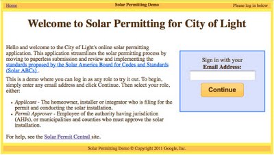
We were inspired to create this code example by the work that SolarTech has done to promote faster permitting through its Solar Permitting Challenge, and by the Solar ABCs efforts to produce a simple, uniform process for solar permitting. The user login screen for the Python code example appears below.
Navigant consulting estimates that there are 700 gigaWatts of solar power generation resource on rooftops in the United States. Overall, we believe that efforts to streamline the workflow connected with rooftop solar installations could reduce the costs of installations by 50 cents/Watt. Please help us help the industry make this a reality.

Google Earth: Gigapixel panoramas

We’ve talked before about Gigapixel images and 3D Panoramas, but it’s not often that the two come together.

For the past year, Thomas Hayden has been shooting gigapixel-quality 3D panoramas, and the quality is stunning. For example, this KMZ file takes you to OMSI (Oregon Museum of Science & Industry) in Portland, OR. Be sure to turn on the “360Cities” layer under the main “Gallery” layer.

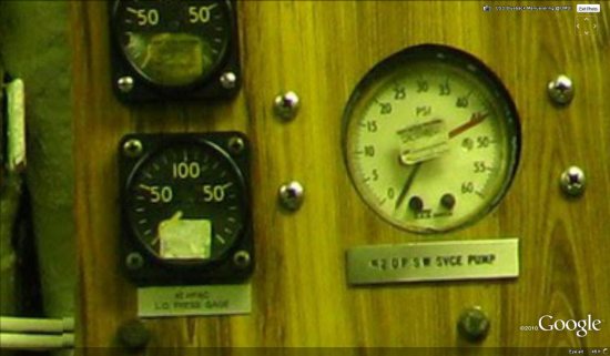
He has recently completed shooting a 42 image set virtual tour of the museum using a GigaPan that allows him to capture very high resolution panoramas. While most GigaPan images you see these days are multi-GigaPixel “framed” panormas, he specializes in almost completely spherical location coverage. These are as high resolution as many popular gigapan images, an order of magnitude higher resolution than the standard methods for virtual tour photography. The standard methods compose a 360 from 5 or 6 individual photos, while he composed these using 112 to 126 individual 8 MP images. The average size of one of his 360s is around 220 MegaPixels (.2 GigaPixels). This resolution allows the viewer to zoom in on very fine details, and in the case of the Manuevering Room of the USS Blueback fast-attack submarine on exhibit at OMSI, allows the viewer to examine the switches, dials, and gauges that move the boat.

dials.jpg

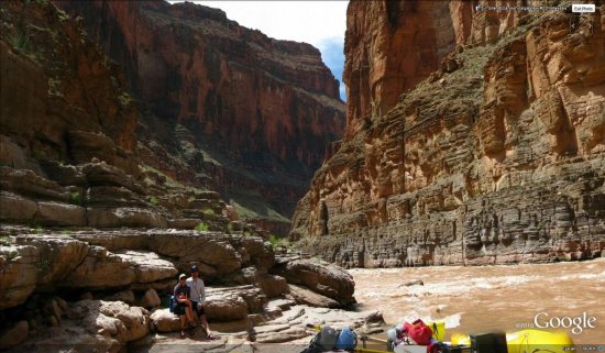
His first project was in creating a virtual tour of the Grand Canyon by rafting the Colorado River for 18 days last April. There are 21 images in all as part of Grand Canyon GigaView that can be found along the river over 225 miles from Lee’s Ferry to Diamond Creek. All of the images very near to the river in the Grand Canyon that are visible on Google Earth are part of Grand Canyon GigaView. Look for the 360Cities red icons near this KMZ file. He has also built a Tumblr blog that serves as a day-by-day trip report and a place to display the media. The imagery from the Grand Canyon is absolutely stunning:

grand-canyon.jpg

For those of you interested in the specifics of how he was able to capture the imagery for these panoramas, he’s explained his equipment in detail:

The equipment I use is half of my story, actually. I generate these images with a five year old, low end, prosumer camera (Canon Powershot S5 IS 8MP) and a GigaPan Epic 100 robotic camera mount. The GigaPan unit is designed to handle almost any brand of point and shoot camera, and together with software, become a high resolution imaging device. The concept spun out of NASA’s Mars Rover Missions where they needed small cameras (low power, light weight) to do great things. The primary resource they knew they would have on Mars was time, so the created this process for turning low end cameras into useful imagers by compositing back on earth. With money from Google, Carnegie Mellon University started the program initially with National Geographic and NASA called the Global Connection Project, which spun out into a company called GigaPan Systems to produce and market an affordable robot+software package that would make thise kind of imaging within reach of the average consumer. In the last year, GigaPan has also produced a beefier unit to manager larger DSLR prosumer cameras and their telephoto lenses.

My Grand Canyon GigaView project is not-for-profit and GigaPan supported the project by providing the Epic 100 I still use today. NRS supplied me with whitewater gear and PNY supplied me a all the SD cards I will ever need, so I had some sponsorship. I was invited on the Grand Canyon Private River Trip permit that my old raft guiding buddy had won last year in the newly formed private permit lottery system that GCNP devised in 2007 to deal with the 25 year waiting list that had become the average wait for a private rafting permit. Because I used to guide and have many friends in the river communities of the Colorado Plateau, this was my second opportunity to row a boat down the Grand Canyon through 225 river miles, 182 named named rapids, and 3 of the largest drops in North America.

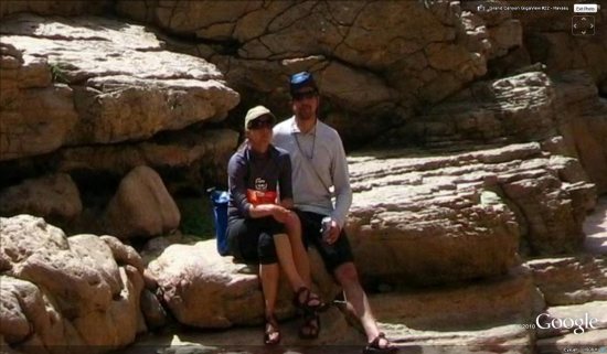
Most of the images are inner canyon landscapes, but when there are people to be found in them, they are usually my fiance and I posing on a overhanging ledge or peering around a bush to see if the GigaPan had finished shooting yet, only to get caught by the robot.

posing.jpg