Not long ago, we showed you some fresh imagery from Joplin, MO, after they were hit by that devastating tornado.
Steve Ansari from NOAA’s National Climatic Data Center (NCDC) recently sent us an amazing file that shows debris from the tornado in a 3D model!
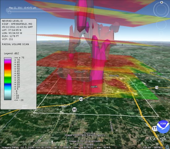
You can view it yourself using this KMZ file.
A report was recently released from NCDC which gives a summary on the Joplin event and includes a flash movie showing the visualization in Google Earth.
The software used to create the KMZ file is the NOAA Weather and Climate Toolkit, which is developed at NCDC.
Here is a bit more about how this works, in Steve’s words:
The Radar site conducts conical sweeps at increasing elevations off the ground and measures the ‘reflectivity’ of particles in the atmosphere. Large rain drops, hail, and in this case debris are represented as high reflectivity values and it is ‘reflectivity’ which we are most accustomed to seeing on television and internet weather maps. Each sweep is represented as a COLLADA model with the semi-transparent Reflectivity image draped on the model. In addition, several isosurfaces are created from the 3D reflectivity volume and represented as polygons in the KML. A tour is also included in the KMZ.