Google Maps: In Search of Ad Space

As Facebook pushes the boundaries of privacy, Google is pushing the boundaries of ad placement. Like all corporations, Google needs to respond to the demands of a market that requires ever increasing income growth. One way to do that in the absence of significant page view growth is to monetize every remaining square inch of Google.

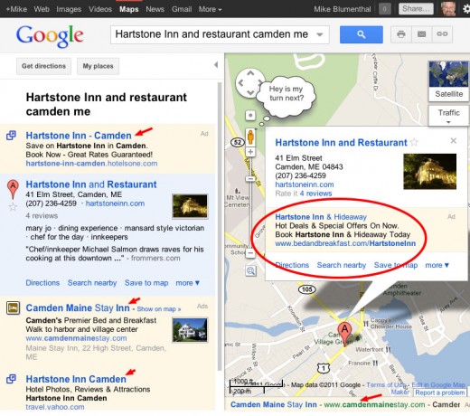
That seems to be whats happening in Maps where Laura Alisanne points out that Google is now placing ads on the info bubble for a given business. This ad, from a competitor, shows on the branded search for the Hartstone Inn & Restaurant.

Next on the “Ad in every square inch” agenda? When visiting Maps we can expect to hear the Pegman start shouting out daily deals.
 

Pacific Crossing in Google Earth

Join a journey of discovery virtually in Google Earth, as Liquid Robotics launches four wave-powered robotic gliders to cross the Pacific ocean in their Pacific Crossing (PacX) Challenge Expedition. The wave gliders are attempting to set a new world record for the longest distance ever attempted by an unmanned vehicle and will be collecting data about the Pacific ocean for use by scientists and students back on dry land. These R2D2s of the sea will cross 25,000 miles over 300 days and collect over 2 million data points, helping build the record of oceanic knowledge.

Wave glider robots await launch from San Francisco in this first expedition blog post in Google Earth.
To follow the wave gliders in Google Earth, download the expedition KML file or open the PacX Gallery page and click on the ship icon. You will be able to read updates from scientists sharing the latest robotic observations, from wave height in storms to weather measurements like barometric pressure, wind speed and air temperature. The ship icon will represent the location of the wave gliders, starting in the San Francisco bay.

Google Map data updates for Europe


With over 600,000 sites actively using the Google Maps API, more people around the world view maps provided by the Maps API than any other source. For this reason it’s vitally important that Google Maps provides the most accurate and up to date map data possible. For this reason we’re happy to introduce updated maps and the “Report a Problem” tool to France, Luxembourg, and Monaco.

As with previous updates in countries such as the U.S.A., Australia, and parts of Europe, this update utilizes a wide range of authoritative sources such as the Institut Geographique National. In addition, the “Report a Problem” tool on Google Maps allows you to let us know if some aspect of the map that needs correcting, and we’ll do our best to address it quickly.

These map updates will roll out over the next 24 hours across all our Maps APIs and related services. As with previous updates we do ask that you refresh any data that you have previously obtained for these countries using Maps API Web Services, and cached for use in your Maps API application. If you have any questions or concerns relating to this, please post them to the Google Maps API forums.