The Google Earth and Google Maps Imagery Team just published a new batch of aerial and satellite imagery, and as always, there’s all kinds of fascinating sites and features to check out.
We’re now deep into the dog days of summer. When I was growing up in Chicago, my siblings and I would be acting a bit stir crazy by this time in our summer breaks. So what did our wise parents do? They’d pile us into the confined space of the family car and proceed to road-trip it for a few weeks. My parents are history buffs, so our destination spots were typically of historical significance. To commemorate these fond memories, in this post we’ll look at locales seen in our newly published imagery that would typically fit the destination profile of my family.
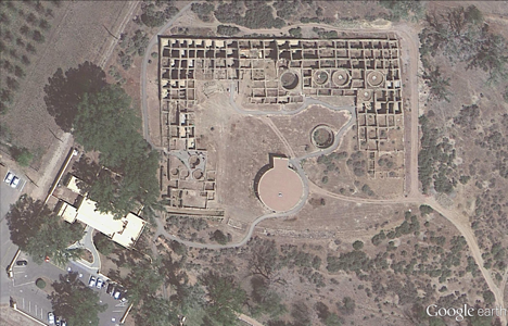
Our first example seen below is from high-resolution aerial imagery acquired this past June. The locale is a U.S. National Park located in San Juan County, New Mexico and contains 11th to 13th century structures constructed by the Anasazi Indians, the ancestors of the more commonly known Pueblo Indians. This site is included in the UNESCO list of World Heritage Sites.
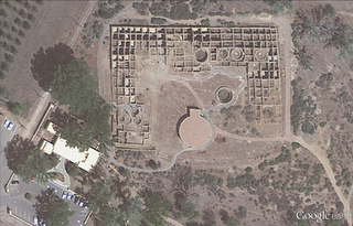
Aztec Ruins National Monument, New Mexico
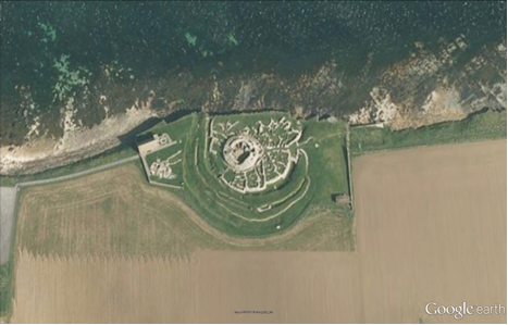
Family vacations outside of the U.S. happened on occasion and when they did, my dad’s fondness for Led Zeppelin would often lead us to any castle or related ruin in sight. In this aerial image, we can see the Broch of Gurness village located on the northwestern coast of Mainland Orkney, Scotland. The top of the central, circular broch structure has collapsed, and we can see the settlement remains that encircle the broch. The site dates to at least 60 AD.
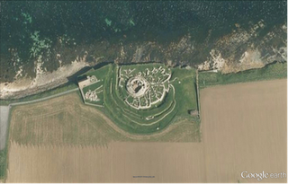
Broch of Gurness, Scotland
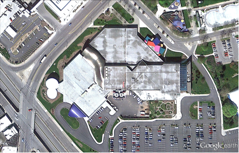
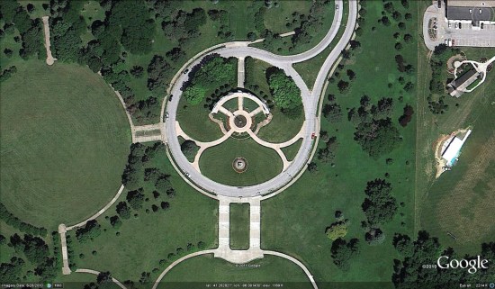
Finally, if we were good children and did not get our peanut butter sandwiches all over the car upholstery, we might be treated to visit a place such as the National Toy Hall of Fame, located in the Strong National Museum of Play, Rochester, New York. Some of the 47-and-counting enshrined toys include road-trip friendly icons such as the stick, cardboard box, ball, and of course Silly Putty!
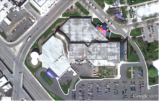
National Toy Hall of Fame, Rochester, New York
Do you have a place you love for which you’d like to receive a notification when the Earth and Maps Imagery team updates the site? We’ve got just the tool: The Follow Your World application!
As always, these are but a few examples of the types of features that can be seen and discovered in our latest batch of published imagery. Happy exploring!
High Resolution Aerial Updates:
USA: Abilene, TX; Avenal, CA; Bakersfield, CA; Big Spring, TX; Bowie, AZ; Buckeye, AZ; Carlsbad, NM; Casa Grande, AZ; Columbia, MO; Dalhart, TX; Dayton, OH; Des Moines, IA; Farmington, NM; Ft Worth, TX; Joplin, MO; Junction, TX; Monahans, TX; Nogales, AZ; Omaha, NE; Paducah, KY; Payson, AZ; Rochester, NY; Sacramento, CA; Sioux City, IA; Tulsa, OK; Visalia, CA; Wilcox, AZ
Scotland: Aberdeenshire, Clova, Islay, Jura, the Orkney Islands, and the Shetland Islands
Sweden: Dalarnas Län, Gotlands Län, Norrbottens Län, Oland, Örebro Län, Västerbottens Län, and Västernorrlands Län
Countries/Regions receiving High Resolution Satellite Updates:
Albania, Algeria, Angola, Antarctica, Argentina, Armenia, Australia, Austria, Azerbaijan, Bahrain, Bangladesh, Benin, Bhutan, Bolivia, Bosnia and Herzegovina, Botswana, Brazil, Bulgaria, Burkina Faso, Burundi, Cambodia, Cameroon, Canada, Cape Verde, Central African Republic, Chad, Chile, China, Colombia, Cuba, Côte d’Ivoire, Democratic Republic of the Congo, Djibouti, Dominican Republic, Ecuador, Egypt, Equatorial Guinea, Eritrea, Ethiopia, Fiji, Finland, France, Georgia, Ghana, Greece, Greenland, Guatemala, Guinea, Guinea-Bissau, Honduras, Hong Kong, Iceland, India, Indonesia, Iran, Jamaica, Japan, Jordan, Kazakhstan, Kenya, Kuwait, Laos, Lesotho, Liberia, Madagascar, Malawi, Malaysia, Mali, Marshall Islands, Mauritania, Mexico, Mongolia, Morocco, Mozambique, Myanmar, Namibia, Nepal, Netherlands Antilles, New Zealand, Nicaragua, Niger, Nigeria, North Korea, Norway, Oman, Pakistan, Panama, Papua New Guinea, Paraguay, Peru, Philippines, Poland, Republic of the Congo, Romania, Russia, Rwanda, Saudi Arabia, Senegal, Serbia, Singapore, Somalia, South Africa, South Korea, Spain, Sri Lanka, Sudan, Svalbard, Sweden, Switzerland, Syria, Tanzania, Thailand, Togo, Turkey, Turkmenistan, Uganda, Ukraine, United Arab Emirates, United Kingdom, United States, Uruguay, Venezuela, Vietnam, Wallis and Futuna, Western Sahara, Yemen, Zambia, and Zimbabwe