Garmin Victor’s Vectors: GTN PC Trainer Lite Online Download

There were hundreds of people who came by the Garmin booth at Oshkosh to get their hands on the GTN series touchscreen avionics. If you didn’t get a chance to come by or you didn’t get to spend as much time with it as you wanted, we’ve got you covered. Garmin recently released a downloadable version of the GTN trainer on Garmin.com called the GTN PC Trainer Lite. This trainer functions just like the real GTN, giving you the opportunity to interact with the intuitive user interface and explore the robust capabilities in more depth.
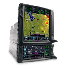
The database coverage on the PC Trainer Lite version is limited to North America and the G500/G600 integration is not available. If you are interested in the full trainer with G500/G600 integration, it is available on disk and can be purchased online. But if you’re just interested in getting to know the GTN and getting a feel for the rich features this system has to offer, then the GTN PC Trainer Lite is for you. You can also learn more by watching our series of GTN familiarization videos, which are all available online:

FOSS4G 2011

Look, I’m a realist when it comes to software and philosophy.  Use what gets your work done faster, more efficiently and without killing the penguins down in Antarctica.  I can’t even remember if open source software is “free as in beer” or “free as in I’m a cheap bastard”.  But what I do know is that if you aren’t familiar with all the tools available to you, there is a chance you maybe be doing things inefficiently and probably incorrectly.

That’s why I think this year, a great opportunity for everyone in North America 1 to make time to visit Denver for FOSS4G 2011 next month.  Since FOSS4G was last in our neck of the woods in 2007, the geospatial world has changed a ton.  So many new projects are available and more mature than ever before.  The choice that we all have today is greater than ever before and FOSS4G 2011 will give us all a chance to see what’s new and how we can use these projects in our workflows. 3 days in Denver will give you the information you’ll need to succeed in this space as it rapidly changes. Siting back and letting the world move forward without you is a recipe for obsolescence.

A quick look at the schedule shows that there are tons of great sessions to be involved with and for those who haven’t been exposed to open source projects before, there is a great Introduction to Geospatial Open Source that will help you get a better handle on your options.  I’ll be there all week and so will most of the big geo-personalitites in our space.  They all realize that this is an opportunity that only comes around once ever 5 years (yes it’s been that long since we’ve had one in North America) and you can’t afford to miss out.

The New Normal Temperatures


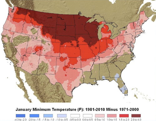
NOAA Climate Normals: January Minimum Temperature (F): 1981-2010 vs. 1971-2000

Whenever I see a weather forecast, it’s usually accompanied by normal temperatures for the day. In NOAA’s case, that normal is calculated from a 30-year average, updated every decade. NOAA just updated those norms, Dan Satterfield reports, and as you might expect, things are a bit warmer: “Climate change is expected to be stronger in northern areas of North America and that trend continues to show up. It is also expected to be more noticeable at night and in winter and that too shows up clearly,” Dan says. Here’s a PDF of the NOAA briefing deck explaining the update, from which the map above is taken: the map shows the increase in degrees Fahrenheit between the 1971-2000 and 1981-2010 normal minimum temperatures for January. Via MAPS-L.