BBC Nuclear Power Map

BBC Nuclear Power Mapped

BBC Nuclear power mapped


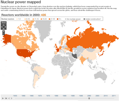
See the development and introduction of Nuclear Power from 1955 onwards with the time slider at the bottom.

BBC Nuclear Power Map.
http://www.bbc.co.uk/news/world-13159407

Notes on the data and map:

Data in the map above is sourced to the IAEA. The map uses current political boundaries.

Data showing the percentage of electricity that nuclear power contributes to each countries’ total electricity production is only available from 1985-2010.
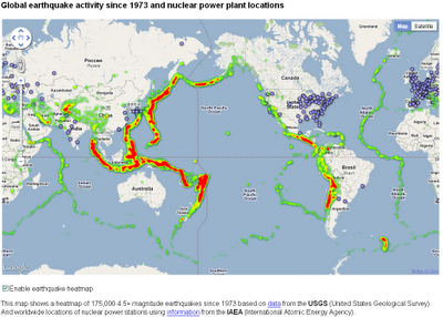
Earthquake Activity & Nuclear Power Stations

Earthquake Activity & Nuclear Power Stations

Earthquake Activity  & Nuclear Power Stations

Earthquakes and Nuclear Power Locations using Google Maps using Fusion Tables with Heat Map. The ‘Pacific Ring of Fire‘ is obvious

http://maptd.com/map/earthquake_activity_vs_nuclear_power_plants/

Source:
http://maptd.com/worldwide-map-of-nuclear-power-stations-and-earthquake-zones/

found by Google Maps Mania comments
http://googlemapsmania.blogspot.com/2011/03/20km-exclusion-zone-on-google-maps.html

With Helicopter over the Japanese Nuclear Plant – scary apocalyptic scene

Helicopter video of Japan’s troubled Fukushima Nuclear plant from yesterday indicates how extensive the damage at the plant is from the earthquake, tsunami, and subsequent explosions.

According to reports, the video was shot about 32 hours ago by a Tokyo Electric Company employee in a Japanese Self-Defense Helicopter surveying the plant. The editors of the video highlight the Fukushima 4 nuclear reactor, which holds the spend fuel rods and looks absolutely destroyed.

It’s a rare up-close view of the plant we’re now only seeing from a long-range for safety reasons and it’s an extremely disheartening one.