New high-resolution underwater terrain in World Oceans Day

In celebration of World Oceans Day, Google has released a significant amount of brand new high-resolution ocean floor imagery, amounting to an area larger than North America!

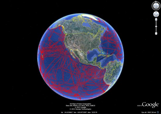
Captured from nearly 500 ship cruises and 12 different institutions, the data was curated by the Lamont-Dohery Earth Observatory. The image below shows the areas that have been udpated:


world-oceans.jpg

To explore more of the new features, Google has created a “Seafloor Updates layer” to show off the highlights, seen here:

The deepest volcanic eruption ever recorded was at the West Mata volcano near Fiji, photos of which can be seen in the Deep Sea Vents Ridge 2000 tour. Coincidentally, Frank is celebrating World Oceans Day by spending a full day diving in the ocean in Fiji. You can read about that experience on the Tahina Expedition blog.

All of this data is fun to look at, but there are some important scientific benefits as well. In particular, a more detailed ocean map can help us understand how tsunamis will spread around the globe. At this point, we know more about the surface of Mars and the Moon than we do about the ocean floor, so advances like these are becoming more critical.

Visualizing the vast problem of marine debris

mdc.jpgWith the fifth international Marine Debris Conference taking place this week in Hawaii, Google and NOAA (the National Oceanic and Atmospheric Administration) have put together some resources to help visualize this growing problem. The conference aims to help provide tools and information, as well as to inspire innovation.

To that end, Google and NOAA have built a tour to showcase some of the major problems our oceans are facing, as well as the main sources of marine debris around the world. To view the tour, you can view the tour in the Ocean Gallery, download it as a KMZ file, or watch the video below:

For more, check out the Google Lat Long Blog or the official NOAA website.

Can I Have One NSDI with Some Confusion on the Side Please?

In this age of publish first, then filter, and instant gratification, it is easy to loose some of the real questions out of sight. The merging of Data.gov and Geodata.gov (yes, that is the plan) raises some questions that have gotten lost in the excitement from the last week.

Here are a couple observations on the subject that could be made by anyone who has been following the two sites over the past year(s):

  1. Geodata.gov harvests most of its content from over 300 other catalogs (visit the Geodata.gov Statistics tab and view the information on Partner Collections). Data.gov does not have this capability. These catalogs represent federal, state, and local government, academia, NGO, and commercial providers of geospatial resources (visit the same tab on Geodata.gov and view the information on Publisher Affiliations). Data.gov on the other hand focuses on content from the Executive Branch of the Federal Government. Where would the remaining content of Geodata.gov go? http://www.otherdata.gov?
  2. Geodata.gov focuses on FGDC+ISO metadata with the industry looking at migrating to the new North American Profile of ISO 191xx metadata. Data.gov has developed its own metadata specification and vocabulary that is quite different from this. Just look at a details page on Data.gov to confirm this. What is the position on this subject of FGDC and other federal agencies who have created standards-based metadata for many years?
  3. Geodata.gov has focused on the GIS analysts and first responders (check the original Statement of Work, I’m sure it’s online somewhere). Data.gov seems to focus on a different audience (although honestly it’s not entirely clear to me if that audience consists of developers or the general public. It’s a bit of both).
  4. Geodata.gov has supported a number of user communities in two ways:
    • by allowing them to create community pages with resources beyond structured metadata that are of interest to those communities. The content in these pages is managed by the communities themselves. How should Data.gov support these communities of interest?
    • by supporting community-oriented collections that group metadata from multiple source catalogs. Examples are RAMONA (the states’ GIS inventory), the Oceans and Coast Working Group (interested in all content in the US coastal zone), and Data.gov (actually, this is also configured as a collection in geodata.gov). These collections are exposed on the Geodata.gov Search tab and in the CS-W and REST interfaces to the catalog.Where would these collections end up after a merger of Geodata.gov and Data.gov?
    • Geodata.gov has created a Marketplace where those who are looking for data and those who have plans to acquire data can discovery each other and collaborate. A dating service of a different kind. While not specifically targeted at the masses, isn’t one of the key principles of NSDI to collaborate to reduce redundant investments?
  5. Geodata.gov has created a search widget that has been implemented by several agencies such as the State of Delaware that enables searching geodata.gov directly from the website and thus getting access to state and other geospatial resources covering the area of the state. This widget can mean significant cost savings for agencies as they don’t have to create their own clearinghouses. Will Data.gov provide such a role as well?
  6. Through FGDC CAP grants several tools were built that work against the Geodata.gov REST or CSW interfaces. I mentioned some of these capabilities and the links to these tools in my recent blog post. Merging Geodata.gov and data.gov would ideally not break these investments.

It would be nice to see the passion that was expressed over the last week be repeated, but now discussing some of these and other questions that affect the geospatial community at large.