Continuously innovating and improving our map data is a top priority and a massive undertaking at Bing. That’s why we’re excited to announce a new initiative to work with the OpenStreetMap project, a community of more than 320,000 people who have built high quality maps for every country on earth. Microsoft is providing access to our Bing Aerial Imagery for use in the OpenStreetMap project, and we have hired industry veteran Steve Coast to lead this effort.
As a Principal Architect for Bing Mobile, Steve will help develop better mapping experiences for our customers and partners, and lead efforts to engage with OpenStreetMap and other open source and open data projects. As a first step in this engagement, we plan to enable access to Bing’s global orthorectified aerial imagery, as a backdrop of OSM editors. Also, Microsoft is working on new tools to better enable contributions to OSM.
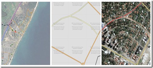
Current OSM editing tools use imagery that is limited in the amount of resolution about the underlying geography (left, center). Bing’s global aerial imagery (right) will enable the OSM community to have access to an unprecedented set of high-quality data, which will enable them to engage in better mapping tasks.
Steve Coast is no stranger to the open community. He founded OpenStreetMap, a wiki map of the world which anyone can help improve, similar to Wikipedia. Steve also co-founded CloudMade, a company that has supported OpenStreetMap from the early days and which provides an innovative mapping platform and tools which utilize OpenStreetMap. CloudMade is a good example of how the market can benefit from the work of the OpenStreetMap project, and Bing Maps is pleased to join them in the community effort to build better maps.
“We’re pleased to see Microsoft investing in the open map community, and we wish Steve all the best in his new role with Bing,” said Christian Petersen, VP Community, CloudMade.
We are looking forward to working with the OpenStreetMaps community to help deliver even better maps for people around the world.
