Google Street View with a Date


The Google Earth Blog noticed that Google Maps Street View images now come with a date telling you when the panoramas were taken.

If you look at the bottom left hand corner of a Street View image you can now view the month and year when the picture was taken.

Another nice little feature I’ve noticed Google Maps testing recently is the highlighting of search results. For a while now when you search for a location in Google it has shown a map with the searched area highlighted. Google have been testing this feature in Google Maps as well.


This feature still seems to be very much in the testing stage. I noticed the feature was working this morning but this afternoon it no longer seems to be working for me.

Finally, in Chrome (but not in Firefox and IE for me) the satellite button in Google Maps now shows the satellite view directly beneath the button.

via:googlemapsmania

Google Earth: Post Japan Earthquake panoramas

In an effort to continue to help keep people informed about the extent of the tragedy that has recently struck Japan, Google Earth has added panorama photos of post-earthquake zones. These photos come from our partner 360cities and can be found in the “Photos” layer in Google Earth, along with other 360cities and Panoramio photos. These dramatic panorama photos are part of the work of photographer, Akila Ninomiya.

In March 2011, Mr. Ninomiya took his camera and bravely ventured into the heart of post-earthquake zones in Iwate Prefecture, Japan. He documented earthquake and tsunami damages in cities including Rikuzen-Takada, Kamaishi, Osawa, Miyako, Settai, and Omoto.

Mr Ninomiya didn’t just take pictures. He took 360 degree panoramas, which give unique perspectives to the extent and severity of this unprecedented natural disaster.

To see his collection in Google Earth, make sure you have the “Photos” layer turned on. Then fly to any of the cities mentioned above, eg. Ofunato, Japan. You will see a number of orange colored photo placemarks. Click on one of them and you will see a picture like the one below:

To see the 360 degree view, click on the center picture in the balloon and it will take you into the panoramas. If you wish to view the post earthquake panoramas only, download this KML collection and open it in Google Earth.

These panoramas were taken as part of a non-profit Japan Pano Journalism Project, which aimed to document the 2011 Japan Earthquake damage and recovery with 360º panoramic photography.

Capture and Share Panoramas Anywhere You Go with the Photosynth App

What does a beautiful mountain pass, your favorite coffee shop, and your blossoming backyard garden all have in common? They’re all places you would love to capture and share, but a single photograph just won’t do.

Today, we’re introducing the official Photosynth app which lets you capture amazing panoramas of your favorite places to share with your friends and even the world with Bing Maps. Photosynth’s interactive panoramas allow you to look left, right, up and down, letting you capture and view more of the places you visit.

Here’s a look at our Photosynth app:

Using the latest computer vision technology, the Photosynth app makes capturing panoramas fun and engaging, while creating sharp, high-resolution results. With the app, you can process, view, and store your panoramas directly on your device. Then, share them in a variety of ways, including to Facebook as images or as interactive panoramas (hosted for free) on Photosynth.net.

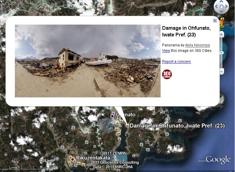
Why are we at Bing so excited about this Photosynth app? Now, you can become part of the Bing Maps experience wherever you go. After capturing a great panorama of a museum you love or a beautiful garden, choose to publish to Bing Maps and it could be seen by the world. From the map, “dive in” and see your panorama next to that museum. Or, experience it seamlessly alongside the museum’s listing in Bing (if tagged with the location name).


With the Photosynth app you can:

  • See your panorama take shape with each picture you take
  • Get high-resolution results in all directions with advanced, on-device stitching
  • See most panoramas within seconds of taking your last picture
  • Zoom, pan, stretch, and view your panorama in landscape or portrait mode
  • Save and view your panoramas on your device and view them online at Photosynth.net

When you’re ready to share your panoramas, you can:

  • Upload to Facebook as images or interactive panoramas (hosted for free) on Photosynth.net
  • Publish your panoramas to Bing Maps for the opportunity to see your panoramas on the map (Using the Bing Maps Photosynth map app) or with Bing local business listings See images of your panoramas automatically saved to the device Camera Roll

The Photosynth app is available now for a variety of iOS devices, including the iPhone 4, iPhone 3Gs, iPod Touch Fourth Generation, and the iPad 2 running iOS 4.1 and later (the Photosynth app is coming next to a Windows Phone near you). You can download the app for free from the iTunes App Store today athttp://www.itunes.com/apps/photosynth