Armelle Caron

Armelle Caron: Paris bien rangé

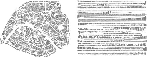
French artist Armelle Caron uses maps in a couple of ways. First, have a look at her organized city maps, executed between 2005 and 2008, in which city blocks are taken apart and organized into neat rows. She does something similar with a world map in Le monde rangé, available as a poster. See also her 2010 series, Les villes en creux, where city blocks are cut out of the paper. Nice effect.

From Buildings to Cities: Techniques for the Multi-Scale Analysis of Urban Form and Function

Duncan Smith here at CASA and Andrew Crooks, an assistant professor in the Department of Computational Social Science, at George Mason University have just finished a new working paper entitled ” From Buildings to Cities: Techniques for the Multi-Scale Analysis of Urban Form and Function .” Below is the abstract : The built environment is a significant factor in many urban processes, yet direct measures of built form are seldom used in geographical studies. Representation and analysis of urban form and function could provide new insights and improve the evidence base for research. So far progress has been slow due to limited data availability, computational demands, and a lack of methods to integrate built environment data with aggregate geographical analysis.