Panoramio- Join a photo community to match your interests

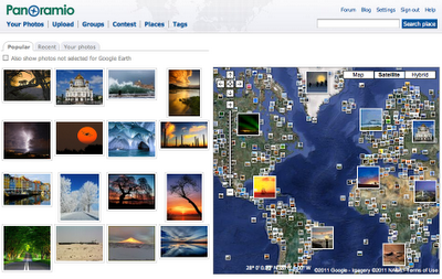
When I get home, I upload my photos to Panoramio and position them on the map. Pictures uploaded to Panoramio can be featured in the “Photos” layer of Google Earth and Google Maps, which means that I can share my travel experiences with others and, in return, explore places around the world through the eyes of other photographers.

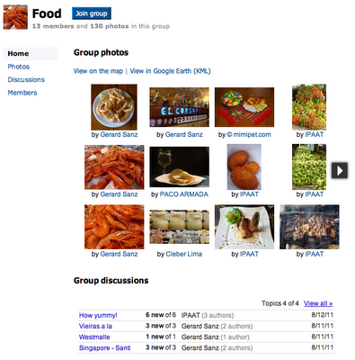
Starting today, you can share your passions through photographs more collaboratively with Panoramio Groups. This new feature lets you create a sub-community within Panoramio around a topic you’re passionate about, so you can easily engage with like-minded photographers and hobbyists.


Panoramio is an online community of people that share and explore photos of the world.

For example, in my trips around the world, I always take the time to enjoy the local cuisine, like Costa Brava’s arròs negre. So I created a group called “Food,” to give others a “taste” of that region and get a glimpse of what fellow foodies are feasting on. My fellow group members—and by all means I hope you’ll become one of them!—can add their own photos, browse others’ and get culinary and travel inspiration.

Panoramio Groups allow members to share photos and start discussions on a given topic.

To share your own interests and passions through photos, hop over to Panoramio and create your own group or join an existing one from the Groups Directory. You can show off your photos of your favorite restaurant, the most beautiful sunset you’ve seen, the latest lighthouse you’ve visited, or the cutest dog from each continent. Whatever it is, try starting a discussion about your favorite topics and share what matters to you with others.
The new Google Maps 5.8 for Android changes

Yestarday, Google Maps 5.8 for Android improves Places and Latitude with:

  • Upload photos for a Place
  • My Places as a simple way to manage the Places you’ve starred and recently viewed
  • Descriptive terms for Places in search results
  • Add a new Place on-the-go when checking in

Photo upload for a Place

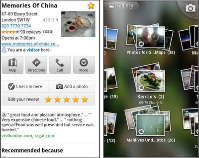
When deciding on a place to go, people often want to know what a place looks like in addition to seeing ratings and reviews. You can now contribute photos to help others get a sense of places. You can now attach your photos to Places, and yours may even become the profile picture for that page. If you want to view or delete any photos you’ve contributed to Places, you can manage uploaded photos in the “Photos for Google Maps” album on your Picasa account.

Left: Uploading pictures to a place. Right: Photos in Android Gallery
My Places and descriptive terms for mobile


In June we announced descriptive terms and ‘My Places’ for the desktop. Both these features are now in Google Maps for mobile. Descriptive terms appear in search results for Places to inform you what businesses are ‘known for,’ such as their ‘eggs benedict’ or being ‘worth the wait.’

Also, My Places for mobile provides quick access to starred and recent Place pages you’ve looked at. You can access My Places by pressing your phone’s menu button while in Google Maps.
Add a new Place ‘on-the-go’ for check-ins


If you’re out and about and want to check in, we want to make sure you can quickly add a new Place to check into if one isn’t available. This might happen for new businesses or those that haven’t set up a Place page yet. For example, let’s say you’re at Xoogle Xtreme Sports, a new sports shop in your neighborhood. You go to check in but don’t see Xoogle in the list of places to check into and when you do a search still nothing comes up.
To solve this, you’ll now see an “Add place” option at the bottom of suggested places. Select that option, and you’ll be prompted to confirm the name and location of the new place. Then a brand new place is added (and you’re checked in). This place will be available for you and others to check into from Latitude, but will not appear as a search result in Google Maps or Google Places.


We’ve also added ‘Bigger text’ to our experimental Labs features and ‘Download map area’ has been renamed ‘Pre-cache map area.’

To start using Google Maps 5.8 for Android, download the update here. This update requires an Android OS 2.1+ device and can be used anywhere Google Maps is currently available. Learn more in our help center.

Street View is digitalizing Japan’s disaster zones

After the March 11 earthquake and tsunami devastated the coastal communities of Eastern Japan, we at Google tried to find ways to use our technologies in support of relief activities. This started immediately after the quake with our Person Finder to help locate displaced individuals, and more recently we’ve started projects to spur economic recovery in the affected areas, such as the “YouTube Business Support Channel,” which enables local businesses to promote their products and establishments to a nationwide audience.

We also believe that the Street View feature in Google Maps can be a useful tool to offer street-level imagery of the recovery efforts. Many photographers felt the disaster couldn’t be captured in just one photo or with a single camera, but immersive, 360-degree panoramic images can help people — especially those abroad — better understand the scope of the destruction.


On July 8, we announced that we’ll be driving our Street View cars across major cities (such as Sendai) and coastal cities of the Tohoku region to not only help communicate the current state of the disaster-affected areas, but also to digitally archive the area’s landscapes for future generations. This imagery will help people in Japan and across the world remember and observe the tragedy of March 11, 2011.

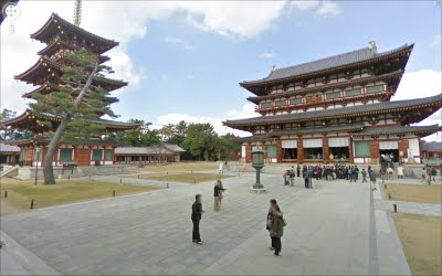
In addition to preserving history through Street View, the team in Japan has been busy publishing 360-degree imagery of more than 100 famous sites across Japan through our Street View Partner Program. The places that have partnered with us to share views of their locations on Google Maps include UNESCO world heritage sites Yakushi-ji temple, Toshodai-ji temple, and Kasuga-Taisha shrine in the ancient capital city of Nara. We’re also continuing the Business Photos project in Japan and are working with hundreds of businesses to photograph their interiors, get those images online, and show both local customers and visitors that they are open for business.

Yakushi-ji Temple in Nara, Japan
If you’re interested in directly supporting the ongoing relief effort in Japan, you can find more information regarding the disaster and resources for those in need at our Crisis Response page in English and Japanese.