Google Earth on 48 screens

Back in 2009, Google developed the first Liquid Galaxy, an entirely new way to display Google Earth on eight screens – which creates an immersive experience of virtually flying around the globe. Since then, we’ve built dozens of Liquid Galaxies all over the world and open sourced the code so anyone can build their own.

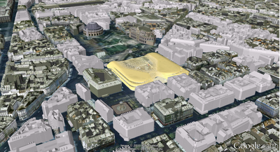
Late last year, the Paris Center for Architecture and Urbanism: Le Pavillon de l’Arsenal, approached us asking if they could use Google Earth to power a new interactive display highlighting the Paris metropolitan area in 2020 with upcoming buildings in 3D. Naturally, we were excited about the project, especially when they shared that the display would be 40 square meters – posing a fun and unique challenge.

A year later, we are excited to share that the first 48 screen Liquid Galaxy is now on display in Paris. We believe this to be the largest screen showing Google Earth to date!

Photo: Vincent Fillon
What started as a 20% project to support the new Google Cultural Institute resulted in a stunning display of the Earth in almost 100M pixels – powered by 48 instances of Google Earth synchronized and operated through 4 multi-touch screens with pinch and zoom functionality. The view is even sharper due to a refresh of the entire Paris area with higher resolution imagery.

As a Parisian, it’s amazing to be able to see what the city will look like in the future. If you can’t make it to France in the near future, you can preview it at home by downloading this KML file and opening it in Google Earth.

The Canopy and Transport Hub: Patrick Berger and Jacques Anziutti architects
This project was a close collaboration between Google and Le Pavillon de l’Arsenal, as well as technology JCDecaux, End Point and design partners ultranoir.

Over the next few months we’ll be fully open sourcing this work on Liquid Galaxy, as well as the graphical interface. Keep an eye out on our source code page for updates.

Biking and walking directions on Custom Maps

You can now use your desktop to create a biking or walking itinerary using Custom Maps in Google Maps. You can choose to share these directions by allowing people to view your Custom Map and avoid the hassle of scribbling them down or printing them out. Additionally, you can access these stored directions from your phone with the Google Maps Android application.

This provides a quick and easy way to navigate trips that have multiple routes and stops when you’re on-the-go. Give it a try the next time you plan a group bike ride or to keep track of your favorite jogging routes.

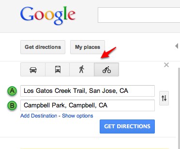
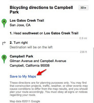
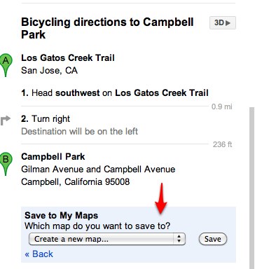
To start, first get directions to your destination(s) and select the biking or walking icon in Google Maps. Next, scroll down to the bottom of the directions in the left-hand panel and click the “Save to My Maps” link.


You can then save the directions to an existing custom map or create a new one. Once the directions have been added to a custom map, you can continue to insert extra stops or make notes. After you complete mapping out your itinerary, you can choose to share it with friends or a workout buddy.

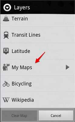
If you have an Android-powered device, you can access stored directions in Custom Maps right from your mobile phone – just click on the layers icon in the upper toolbar and select the saved Custom Map you want.

If you don’t have an Android phone, you can open your Custom Maps using your phone’s browser and visiting maps.google.com.


How the Google Maps API limits affect your site

Several weeks ago we shared an update about the introduction of usage limits to the Google Maps API. Today I’d like to provide additional details about these limits, the types of sites that may be affected, and as promised, equip you with the means for measuring your site’s Maps API usage.

Usage limits and affected sites

Usage limits are being introduced to secure the long term future of the Maps API, while minimising the impact on developers. We have purposefully set the usage limits as high as possible – at 25,000 map loads per day – to minimise the number of affected developers, while ensuring that the service remains viable going forward. Based on current usage, only the top 0.35% of sites will be affected by these limits, meaning that the Google Maps API will remain free for the vast majority of sites.

We recognise that sites may occasionally experience spikes in traffic that cause them to exceed the daily usage limits for a short period of time. For example, a media site that uses a map to illustrate a breaking news story, or a map-based data visualization that goes viral across social networks, may start to generate higher traffic volumes. In order to accommodate such bursts in popularity, we will only enforce the usage limits on sites that exceed them for 90 consecutive days. Once that criteria is met, the limits will be enforced on the site from that point onwards, and all subsequent excess usage will cause the site to incur charges.

Please be aware that Maps API applications developed by non-profit organisations, applications deemed by Google to be in the public interest, and applications based in countries where we do not support Google Checkout transactions or offer Maps API Premier are exempt from these usage limits. We will publish a process by which sites can apply for an exemption on the basis of the above criteria prior to enforcement of the limits commencing. Non-profit organizations are also encouraged to apply for a Google Earth Outreach grant, which provides all the additional benefits of a full Maps API Premier license.

Evaluating API usage by your site

To help you measure your site’s Maps API usage, we have now added the Maps API to the Google APIs Console. The Google APIs Console is a centralised dashboard for Google’s developer offerings, and we encourage all developers, no matter how big or small your application, to create an APIs Console account.

We are initially introducing the limits for Maps API v2 and Maps API v3 map loads. The Maps Image APIs, and differentiated pricing and limits for Maps API v3 Styled Maps, are not currently included in the APIs Console, but will be added in the future. Once you’ve created an APIs Console account, please follow the instructions in the Maps API documentation to enable Maps API v2 or Maps API v3 on your APIs Console Project, and update your application to provide your APIs Console key when loading the Maps API.

After updating your Maps API application, you will begin to see your usage reported in the APIs Console.


via: GoogleGeoDevelopers