Mentoring Organization Applications is Accepted for Google Summer of Code 2012!

Interested in finding bright, enthusiastic new contributors to your open source project? Apply to be a mentoring organization in the Google Summer of Code program. We are now accepting applications from open source projects interested in acting as mentoring organizations.

Now in its eighth year, Google Summer of Code is a program designed to pair university students from around the world with mentors at open source projects in such varied fields as academic research, language translations, content management systems, games, and operating systems. Since 2005, over 6,000 students from 90 countries have completed the Google Summer of Code program with the support of over 350 mentoring organizations. Students gain exposure to real-world software development while earning a stipend for their work and an opportunity to explore areas related to their academic pursuits, thus “flipping bits, not burgers” during their school break. In return, mentoring organizations have the opportunity to identify and attract new developers to their projects as these students often continue their work with the organizations after Google Summer of Code concludes.

This year we are again encouraging experienced Google Summer of Code mentoring organizations to refer newer, smaller organizations they think could benefit from the program to apply. Last year we had 49 of these small organizations join the program and we hope the referral program will again bring many more new organizations to the Google Summer of Code program.

The deadline for applying to be a mentoring organization for Google Summer of Code is Friday, March 9th at 23:00 UTC (3pm PST). The list of accepted organizations will be posted on the Google Summer of Code site on Friday, March 16th. Students will then have 10 days to reach out to the accepted organizations to discuss their project ideas before we begin accepting student applications on March 26th.

Please visit our Frequently Asked Questions page for more details. For more information you can check out the Mentor Manual and timeline for and join the discussion group. Good luck to all of our mentoring organization applicants!

The pyKML – a Python library for manipulating KML

pyKML is an open source Python library for generating, parsing, and modifying KML, the geo-spatial data language used by Google Earth, Google Maps and a number of other GIS platforms.

I was motivated to create pyKML because I frequently need to visualize large, and often complex, environmental datasets. While the KML language has a wide range of options for styling, annotating and interacting with geo-spatial and temporal data, most programs that generate KML don’t take full advantage of these rich features. I created the pyKML library to address this problem by providing easy, programmatic access to all KML elements.

pyKML facilitates working with large and complex KML documents by leveraging the use of basic programming constructs (looping, branching, etc.). In this regard pyKML is similar to libkml, Google’s open source C++ library, but takes advantage of the highly readable syntax of the Python programming language and the processing capabilities of the popular lxml Python library.

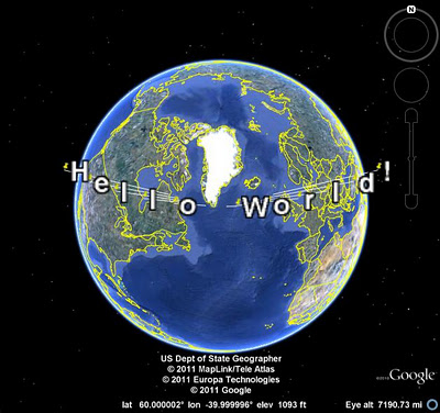
As a simple example, check out this Python script that loops through a text string (“Hello World!”) and uses pyKML to create a series of KML Placemarks. You can download the resulting KML document, and below is a screenshot of how it looks in Google Earth.

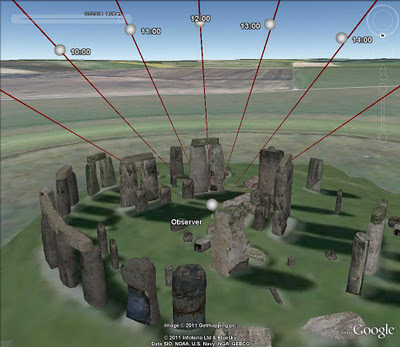
This is just a teaser of what pyKML can do. For more complex examples, check out the pyKML documentation and the project’s Google Code site that includes sample code for: generating KML from CSV data, creating KML Tours, and visualizing ephermeris data for Stonehenge (e.g., orientation of the sun on different dates). pyKML can even be used to create “slides” for presentations!

To get started, browse the project’s documentation, install the library, try it out, and let us know what you think!

via:  Tyler Erickson, Senior Research Scientist / Engineer, MTRI

Bing Maps Aerial Imagery into Desktop themes

Some of the best imagery from the Bing Maps Global Ortho Project is collected into Windows 7 Desktop Themes.  These themes change your PC desktop experience as the images rotate through on a regular basis so you never know which part of the world you’ll be looking at next! The United States version is the most content-rich Windows 7 Desktop Theme with nearly 200 images from all parts of the Continental United States, and has had almost a million downloads. The European version just launched last month and contains photos from 10 different countries in Western Europe. Once downloaded, both of these themes are updated through RSS feeds as new imagery is available. For a deeper dive on these themes, check out this post . What are you waiting for? Go download one today!

Bing Maps Aerial Imagery – United States
Windows 7 desktop theme
Click here to Download
Click here for Details

Bing Maps Aerial Imagery – Europe
Windows 7 desktop theme
Click here to Download
Click here for Details