Traffic information from Google Maps in Sweden and Taiwan

When you turn to Google Maps to get from A to B, we want to help you find the quickest way to get there. Knowledge about the current traffic conditions on the roads can help you determine when to set out on your journeys and which routes to take.

With this in mind, we’ve just expanded our coverage of traffic information on Google Maps to include Sweden and Taiwan. Users in both places can now check the latest on road congestion with their desktop browsers or mobile phones. The traffic information covers all major thoroughfares as well as arterial roads in select cities.

Traffic information around Stockholm, Sweden

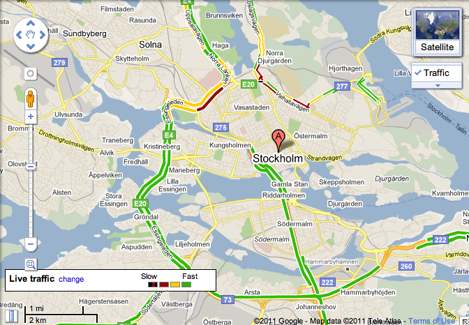
When accessing Google Maps, the widget in the upper-right allows you to select additional map layers that display more detailed information. To view traffic information, move your mouse over the widget and select the “Traffic” layer. The colors you see indicate the current traffic speed relative to the speed limit of the road. Red/black means stop start traffic, red is heavy congestion, yellow is a little slow, and green means you’re good to go. This traffic information is updated every few minutes.

While on the go, you can see this same useful information by enabling the traffic layer on Google Maps for mobile, and help improve the traffic data as well. Here’s wishing everyone safe and swift travels!

Google Maps: Helping you find the right route

With directions in Google Maps, we’re working on helping you find the quickest way to get around, and now finding the right route is a bit easier. For areas with transit information in Google Maps, previously you could compare driving and transit directions by selecting the appropriate icon. Now, when you search for driving directions, transit options may appear directly in the results.

This comes in handy as I visit Madrid and want to find my way from the Hotel Miguel Ángel to the Parque de Atracciones de Madrid. When I search for “Hotel Miguel Ángel, Madrid to Parque de Atracciones de Madrid, Madrid” in Google Maps, I now see the following set of suggestions:

You can see a link to public transit options directly in your driving directions, together with the estimated travel time and number of transfers, for areas where we have transit coverage. This link will appear based on whether public transportation seems like a good alternative for your trip. Similarly, if you’re viewing public transit directions, we may add driving (or taking a taxi) as an alternative.

This feature is currently available in New York, San Francisco, Madrid and Zürich, and we plan to roll this out for more cities in the coming weeks.