The Amazonian Street View

With Google Street View, you can do amazing things such as hike around Stonehenge or even ski down Whistler’s slopes—all without leaving home. Soon, you’ll be able to float down the Amazon and Rio Negro Rivers of northwest Brazil and experience some of the most remote and biodiverse areas in the world.

A few members of our Brazil and U.S. Street View and Google Earth Outreach teams are currently in the Amazon rainforest using our Street View technology to capture images of the river, surrounding forests and adjacent river communities. In partnership with the Foundation for a Sustainable Amazon (FAS), the local non-profit conservation organization that invited us to the area, we’re training some of FAS’s representatives on the imagery collection process and leaving some of our equipment behind for them to continue the work. By teaching locals how to operate these tools, they can continue sharing their points of view, culture and ways of life with audiences across the globe.

We’ll pedal the Street View trike along the narrow dirt paths of the Amazon villages and maneuver it up close to where civilization meets the rainforest. We’ll also mount it onto a boat to take photographs as the boat floats down the river. The tripod—which is the same system we use to capture imagery of business interiors—will also be used to give you a sense of what it’s like to live and work in places such as an Amazonian community center and school.

Image of the Tumbira community in the Rio Negro Sustainable Development Reserve
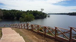
In this first phase of the project, the Google and FAS teams will visit and capture imagery from a 50km section of the Rio Negro River, extending from the Tumbira community near Manaus—the capital of the state of Amazonas—to the Terra Preta community. We’ll then process the imagery of the river and the communities as usual, stitching the still photos into 360-degree panoramics.

Image of the Tumbira Community

For many outdoor enthusiasts, travelers and environmentalists, this creates an opportunity to experience the wonders of the Amazon, which will be accessible in a way they’d previously only dreamed about. We’re honored to work with FAS on this project to bring the Amazon online for those who can’t visit in person, and help our partners share with the world the unique stories of its inhabitants and the beauty of this place they call home. 

London Tube Map

London Geographic Tube Map

London Geographic Tube Map

Mark Noad created this geographical London Tube Map. Showing all stations on the underground network related in real-world locations. Note the River Thames is a realistic shape.

The map is an unofficial response to a recent backlash against the original version, created designed by Harry Beck. This is often described as a ‘classic’ schematic map , showing routes and stations logically rather than geographically.

London Original Tube Map

Harry Beck’s original tube map – http://en.wikipedia.org/wiki/Tube_map

View the geographical version:http://www.london-tubemap.com/

OpenCaching.com: Take the 2011 Kansas State Park Challenge

Having recently announced our new Series Caches, in which you can group similar caches to form a collection at OpenCaching.com, we’re excited that the Kansas Department of Wildlife, Parks and Tourism has used this new tool to create their 2011 State Park Challenge. This statewide contest, which has a total of 31 participating State Parks and Wildlife Areas, began in May and ends on Nov. 1. Only Official KDWPT Challenge caches are eligible for this statewide contest, and a complete list of rules, prizes, and entry forms can be found at KDWPT’s website.

You can find the special KDWPT Series page at OpenCaching.com by clicking this link, which makes it simple to download the whole batch. And even if you don’t complete all 31 caches, you can still submit a partially completed form to KDWPT and be entered to win some great Garmin accessories. If you have a similar idea for a Series or a promotion, contact us at http://bit.ly/OCmail and we’ll work together to get things up

The Kansas Department of Wildlife and Parks currently manages 24 state parks across the state and The Prairie Spirit Trail. Most have access to reservoirs and wildlife areas. Many also have trails for hiking, biking or horseback riding. Fifteen state parks (Cedar Bluff, Cheney, Crawford, Cross Timbers, El Dorado, Eisenhower, Glen Elder, Kanopolis, Lovewell, Milford, Perry, Prairie Dog, Tuttle Creek, Webster, Fall River, Pomona and Wilson) now provide cabins, both primitive and modern. A few parks are preserved natural areas, allowing visitors to enjoy unspoiled wild Kansas. Many parks host annual events such as concerts, festivals, and competitions. Whatever your outdoor interest – hiking, camping, wildlife observation, fishing, bike riding, horseback riding, hunting, or just plain relaxing, a Kansas state park has what you’re looking for. If you’ve never been to a Kansas state park, visit the website at http://www.kdwp.state.ks.us/ to find brochures for each of the Kansas state parks.