Google Earth: The city lights


The “Earth at Night” layer remains a very unique way to view the earth. Captured on the “dark side” of the planet, depending on the time of day, the images are a striking visual of the more urbanized areas of the planet.


lights.jpg 

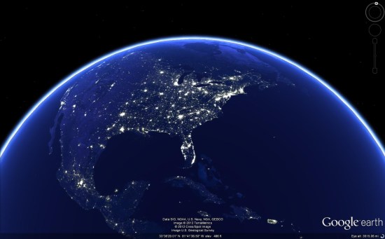
However, the images were not easy to capture. For years, astronauts would try to capture the bright lights and only have blurry photographs to show for it, as the earth travels beneath them at 4.4 miles/second.

In 2003, Don Pettit developed an innovative system for capturing these images and he went on to capture over 2,500 photos, with thousands more captured in subsequent missions. You can read more about Don and his technique in this article at Air & Space Magazine.

To see the lights for yourself, simply click on the [Layers] in Google Earth, open [NASA], then [Earth City Lights] and click the button in there.. For the best results, disable your other layers and places to get a nice clean view of the earth. You should likely disable the atmosphere as well (under [View] –> [Atmosphere]), but I kind of like the glow it gives. It’s a neat effect.

A big thanks to Don for pioneering this amazing technique, and hopefully as time goes on this imagery will become even higher-quality and more striking.

Strange structures in the Chinese desert


As reported by a handful of readers, a popular story about “strange lines in China” is making its way around the internet. There are a variety of odd-looking items in the area of the Kumtag desert, but this one is the most striking:


lines.jpg 

You can view that location in Google Earth by using this KML file.

The big question is: what is it? Some theories I’ve seen floating around online:

• Calibrating grid for a Chinese spy satellite.

• Lines drawn with white material.

• Dust dug by machinery.

• Street map of Washington, DC.

There’s certainly other possibilities as well. What do you think it is?

(via Gizmodo)

Strange structures in the Middle East


First discovered in 1927 by British Royal Air Force fliers, the strange wheel-shaped structures in the middle east are gaining new attention thanks to Google Earth. Researchers have discovered thousands of them in Peru, Jordan, and other nearby countries.


wheels.jpg 

Some believe that the structures were used to contain animals, but there is no consensus about that. According to an article on CBSNews.com:

In Saudi Arabia, (David) Kennedy’s team has found wheel styles that are quite different: Some are rectangular and are not wheels at all; others are circular but contain two spokes forming a bar often aligned in the same direction that the sun rises and sets in the Middle East.

The ones in Jordan and Syria, on the other hand, have numerous spokes and do not seem to be aligned with any astronomical phenomena. “On looking at large numbers of these, over a number of years, I wasn’t struck by any pattern in the way in which the spokes were laid out,” Kennedy said.

The function of the wheels may also have been similar to the enigmatic drawings in the Nazca desert.

“If we consider, more generally, the stone circles as worship places of ancestors, or places for rituals connected with astronomical events or with seasons, they could have the same function of [the] geoglyphs of South America, the Nazca Lines for instance. The design is different, but the function could be the same,” she wrote in her email.

Kennedy said that for now the meaning of the wheels remains a mystery. “The question is what was the purpose?”


Beyond that, what do you think the purpose of these wheels was for? Practical, religious, astronomical, or something altogether different?