FME Webinar: Practical Techniques for Loading Data Into SQL Server

Ed Katibah says that there will be a Webinar next week on loading data into SQL Server Spatial.

One of the most often asked questions about SQL Server Spatial is “How do I load data into the spatial types?”. Safe Software has long provided solutions for this dilemma with their excellent ETL tool, Feature Manipulation Engine (FME).  On December 14th, Safe will be presenting an FME Webinar entitled “Practical Techniques for Loading Data into SQL Server”.

Sounds interesting as Esri doesn’t really give you the right tools to load data into SQL Server Spatial like FME does.
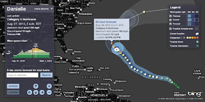
Hurricane Tracker Bing Maps

Hurricane Tracker Bing Maps
*Hurricane Danielle is now a category 4 (major hurricane)

See current locations, forecast paths and detailed stats for any active hurricane this season (2010)

Hurricane Tracker Bing Maps
Currently Hurricane Danielle 2010 – Currently Category 4

  • Profile view of wind speed & forecast wind
  • Animated symbols
  • Lighten darken map
  • Possible forecast error shown

View the Hurricane Bing Map
http://www.msnbc.msn.com/id/26295161/

source:
http://bingmapswatch.blogspot.com/2010/08/hurricane-tracker-bing-maps.html

Another very good and interactive map to track Hurricanes is Stormpulse.

Hurricane Danielle Stormpulse Map

http://www.stormpulse.com/

Mapperz Mapping News Blog