Google I/O extends virtually around the world

In celebration of Google I/O 2011, many Google offices around the world, as well as GTUG partners and Student Ambassadors, are hosting free viewing parties of Google I/O sessions. If you can’t attend Google I/O in person, these events are a way to connect with other talented developers and watch live feeds of the conference.

Part viewing party and part community building, Google I/O Extended events are free and worldwide, focused on bringing the developer community together to live-stream the keynote and other major sessions of Google I/O. Each location’s event will be a little different, so check the registration page of the closest location to see what they have planned. With limited space, registration is required. Learn more and find an I/O Extended event near you on the I/O Extended site. These events are being organized by local developer community leaders and university ambassadors, so please reach out to them specifically if you have any questions about the details.

Here are just a few of the locations hosting an I/O Extended event:

Africa

Asia

Europe

North America

South America and Central America

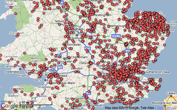
See more locations on the map and register for a Google I/O Extended event in your area.

We look forward to having you join us for Google I/O Extended!

Rain Alarm Map

Rain Alarm Map


Rain Alarm Map

Get live alerts for incoming rain or snow.

The simple idea of this web map and app is to warn you against approaching precipitation like rain or snow. Therefore the app checks in a perimeter of 75 km / 47 miles every 30 minutes, if there is something approaching. Simply leave the page open in the background and you’ll get notified.

Note that the map is refreshed automatically so you do not have to reload the page. The buttons on the bottom right en- or disable the animation and the alarm functionality.

The data used originates from governmental weather services and is available for the USA, Canada, Australia, the UK, Ireland, Norway, Germany, the Netherlands, Spain including the Balearic and the Canary Islands.

Browsers:
The alarm notifications work best with Google Chrome. For Mozilla Firefox and Microsoft Internet Explorer the alarms work as well, though they are not as pretty and intuitive.

With some browsers your location can be determined automatically or otherwise a rough estimate is used. To correct your location, simply drag the marker to be able to receive correct alarms.

Internet Explorer
You need to keep Rain Alarm as the active tab to be able to receive alarm notifications even when the Internet Explorer is minimized.

Mobile

The app is also available for Android as well as iOS.

Map:
http://www.rain-alarm.com/

Five Great Fusion Tables + Maps Examples

WikiEDdata – Mapping Poverty in Washington School Districts


The most powerful maps allow users to quickly understand the significance of large amounts of data. Using Fusion Tables, polygons representing school districts and poverty levels are rendered and colored based on their assigned values in the tables.

Clicking on a district polygon will bring up an infowindow containing a poverty line data chart, dynamically generated through the Google Chart API.

Reporting Road Potholes in Spain


Fusion Tables makes crowdsourcing easy. Using Fusion Tables, Otrobache.com allows Madrid citizens to log on and report the location of potholes. The newly reported potholes appear on the map in real time (as soon as the map is refreshed).

The Telegraph – UK Charities Map


Fusion Tables is a great way to store and quickly render large amounts of data. The Telegraph used Fusion Tables to catalog and map literally tens of thousands of charities throughout the UK.

Analyzing Concealed Handgun Licenses in San Antonio


From San Antonio Express-News, “The Texas Tribune analyzed a Department of Public Safety database that tracks concealed handgun licenses in Texas. The Tribune’s analysis found that the number of gun permits in an area often correlates with income and political beliefs.”

Fusion Tables is used here to overlay the data with boundaries and view possible correlations. The implementation also makes use of Gradient styling. Gradients allows developers to specify a color ramp and a number range; features will be displayed in the color appropriate for where they belong in the range. Much like the built-in Intensity map visualization, but now you can change the colors and use your own boundaries!

Boris Bikes on Fusion Tables


Using geometry styling controls in Fusion tables, this implementation is a live visualization of London Cycle Hire Rank availability using data from the Boris Bikes API.