Strange structures in the Chinese desert


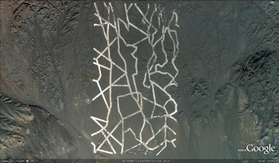
As reported by a handful of readers, a popular story about “strange lines in China” is making its way around the internet. There are a variety of odd-looking items in the area of the Kumtag desert, but this one is the most striking:


lines.jpg 

You can view that location in Google Earth by using this KML file.

The big question is: what is it? Some theories I’ve seen floating around online:

• Calibrating grid for a Chinese spy satellite.

• Lines drawn with white material.

• Dust dug by machinery.

• Street map of Washington, DC.

There’s certainly other possibilities as well. What do you think it is?

(via Gizmodo)

Street View imagery in Belgium


Along with the ski resorts , Google has now pushed out new Street View imagery across Belgium.


belgium.jpg 

The coverage in Belgium is remarkably comprehensive, with virtually every road now viewable in Street View. To see it for yourself, just search for “Belgium” in Google Earth, then drag the peg man on to the map.

Google Street View with a Date


The Google Earth Blog noticed that Google Maps Street View images now come with a date telling you when the panoramas were taken.

If you look at the bottom left hand corner of a Street View image you can now view the month and year when the picture was taken.

Another nice little feature I’ve noticed Google Maps testing recently is the highlighting of search results. For a while now when you search for a location in Google it has shown a map with the searched area highlighted. Google have been testing this feature in Google Maps as well.


This feature still seems to be very much in the testing stage. I noticed the feature was working this morning but this afternoon it no longer seems to be working for me.

Finally, in Chrome (but not in Firefox and IE for me) the satellite button in Google Maps now shows the satellite view directly beneath the button.

via:googlemapsmania