London Calling

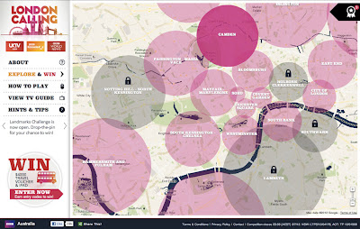
Map of the Week: London Calling
Why we like it: This map is a great way to promote a city and share its history. A brilliantly designed UI, that includes info windows with map cutouts. Additionally, it’s an elegant use of Styled Maps.

In honor of a big year for the city of London, the BBC Australia has created “London Calling” as a way to explore and celebrate London. For those of you who know your way around London, there’s a ‘drop-the-pin’ challenge, where users answer geography questions by placing a pin on the map in the right place. If you get stuck with particular questions, there’s also the option to reach out to the “London Calling” team.

For those that just want to explore London, the map is a great way to learn more about the city that has been getting a lot of attention in light of the Queen’s Jubilee and the upcoming 2012 Olympics. There’s even a chance to win prizes just by exploring the map!

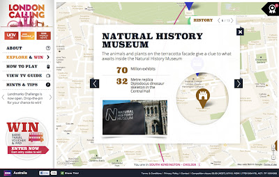
From a design standpoint, this map is really great to look at. Two things about this map really stand out to us. Firstly, Styled Maps has been used to add a sepia effect that reflects the rich history of the city of London. Secondly, this is one of the first use cases where we’ve seen a custom info window that includes a cutout to reveal the highlighted feature below. A clever design choice that’s great to look at!


Google Maps API v3: Business icons and styling

When visiting an unfamiliar city for the first time, I often pick up a tourist map when I check-in to the hotel. Tourist maps are distinctive because they apply equal emphasis to the landmarks of the city as they do to the street names and intersections. Landmarks can be extremely valuable for navigational purposes, and for this reason we add icons for prominent businesses and points of interest on Google Maps as you zoom in. These business icons can be clicked to view additional information about the business, such as the rating, address, and phone number.

At Google I/O this year we began integrating access to business information into the Maps API v3 with the launch of the places library, which adds Places Search and Autocomplete. As part of our ongoing effort to extend this integration, deliver a detailed and complete map, and offer a consistent user experience between Google Maps and the Maps API, we will shortly be adding these clickable business icons to the Maps API v3 as well.

If your application does not specify a specific version of the Maps API to load these icons will appear on the map by default from early next week, unless you are a Maps API Premier customer. The business icons will be classified with the poi.business Styled Maps feature type. If you would prefer that your Maps API application not include these icons, you can remove them ahead of next week’s release by setting visibility:off on the labels element of poi.business for your map. Maps API Premier customers who would like their maps to include these icons can enable them today by setting visibility:on.

You can preview these icons, and the InfoWindow that is shown when they are clicked, on the map below:

In order to allow you to control visibility of these icons, and other features, across all the default map types, you can also now specify styles for your map in MapOptions. This enables you to selectively restyle roads, labels, and other features on Hybrid and Terrain maps in addition to Road Maps. Note however that the base satellite imagery (for Satellite and Hybrid maps) and base relief imagery (for Terrain maps) cannot be restyled.

For more information on setting map styles across map types, please see our updated Map Styling documentation. The Styled Maps Wizard has also been updated to apply styles across all maptypes. As always, if you need assistance applying styles to your Maps, or have any other Maps API questions, we recommend you post your questions to the Maps API v3 Forum.

The Art Of Google Maps

InstaEarth

Instagram is an exciting photography tool, but what really takes Instagram to the next level are applications like InstaEarth from Modea. InstaEarth is an easy way to search for and discover Instragram users and photos on a map. The application makes use of the Places API with Autocomplete to help users to search around a landmark or address. From InstaEarth, “InstaEarth is a way to discover and view beautiful Instagram photography taken around the world. View your feed, friends’ feeds, popular photos, or navigate the map and explore the world through the eyes of Instagrammers everywhere.”

TeleGeography – Submarine Cable Map

When you make a phone call or send an email abroad, most of the time that data travels by way of submarine cables. Submarine cables are the backbone of the global economy, so it’s fascinating to spend time exploring a map that shows where these cables are located. In addition to being a really interesting, fun, and a great looking map, this map is also technically savvy application. Each line representing a submarine cable is clickable and when selected grays out the other cables for better visibility. The map also uses Styled Maps to help the cables stand out better and Fusion Tables to help manage the data on the back-end.

DART St. Louis

There are two things I love to geek out on: maps and photography. That’s why I love this map from DART St. Louis. From their website, “In April 2011 over 250 creative St. Louisans gathered to throw darts at a huge map of the City of St. Louis. Participants then had one month to visit the area where their dart landed and make a photograph. The resulting collection of photographs shows a snapshot of St. Louis as it is today, one random block at a time.”

Berliner Morgenpost – Berlin Elections Map

This month we have yet another great map from Germany. Using Fusion Tables, Berliner Morgenpost mapped out the results of the September 2011 Berlin elections. Voting districts are colored coded by which political party received the majority of votes. Additionally, you can click on any one of the voting districts which will display an infowindow with a chart of the full voting results. This an excellent example of Google Maps API supporting the democratic process and bringing better transparency to government.

Dodge Journey Search

To promote the new Dodge Journey, Dodge is running a competition on YouTube where users can win one of three brand new Dodge Journeys. Video clues are released on YouTube to help users track down the secret location of the vehicle and if they find it, they own it. The clues are related to places in the real world, so users can rely on Google Maps and Places to help them figure out where the car is located. The Maps API serves as the hub of information for this competition and uses Styled Maps to match Dodge branding along with the Places API with Autocomplete to help users follow up on clues.

By Carlos Cuesta, Geo APIs Product Marketing Manager