Digital Heritage Mapping is a non-profit organization that specializes in virtual documentation of global cultural heritage sites. Their flagship initiative, Diarna: Mapping Mizrahi Heritage pioneers the use of digital mapping and database technologies to virtually preserve and ensure open access to endangered Jewish heritage sites across the Middle East and North Africa. The goal of the project is quite similar to the Global Heritage Network that we recently showed you.
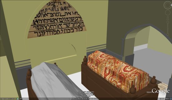
As part of their expanding coverage, they have constructed an amazing 3D model of the traditional tomb of Esther and Mordechai in Hamadan, Iran. Erin, the model’s creator, built this under the direction of Yassi Gabbay, the architect who restored the actual tomb in the 1970s and who constructed the iconic gate and the subterranean synagogue. The synagogue has a Jewish Star-shaped skylight, perhaps the only Jewish Star visible from space (the known other, which was also in Iran, is believed to have been destroyed).
The building is not yet available in the base 3D models layer of Google Earth. However, you can view this model in Google Earth by simply downloading this KMZ file .
.
More about the Diarna project:
Diarna, “Our Homes” in Judeo-Arabic, weaves and synthesizes satellite imagery (complete with terrain, zoomable perspectives, tiltable views, and 360-degree rotation), photographs, videos, oral history, immersive panoramas, and three-dimensional models to offer a unique digital window onto sites and communities disappearing before our very eyes. As structures decay and the last generation to live in these locations passes on, we are in a race against time to preserve priceless cultural treasures. Diarna recently launched D’fina: Jewish Treasures of Southern Morocco, an online exhibit of Judeo-Amazigh (“Berber”) and Holocaust sites that was made possible with grant from the Cahnman Foundation.